Property Record
W Vienna Rd, Clio, MI 48420

Property Detail
W Vienna Rd
18-21-100-061
A PARCEL OF LAND BEG E 934.48 FT & S 0 DEG 16 MIN W 400 FT FROM NW COR OF SEC TH E 347.85 FT TH S 0 DEG 09 MIN W 328.69 FT &
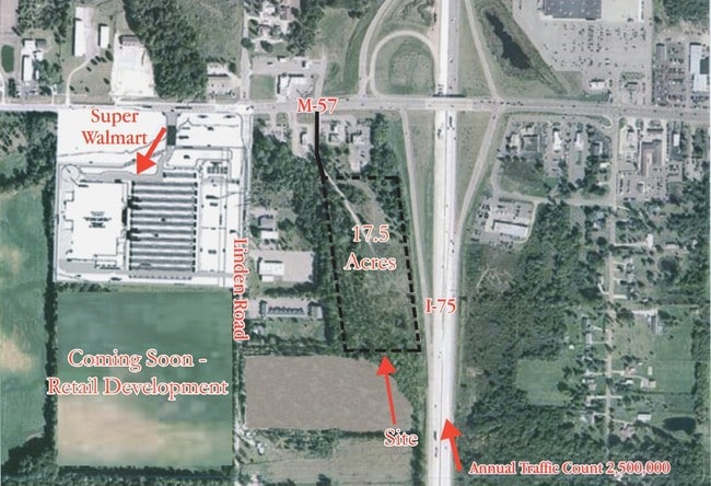
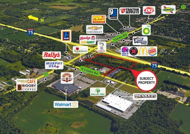
Commercialacreage
GENESEE
C-4
Michigan
B and X Area of moderate flood hazard, usually the area between the limits of the 100-year and 500-year floods.
17.10 AC
2024
Flint
2025
Detroit
010110
Flint, MI
NEARBY LISTINGS FOR SALE OR LEASE
-
-
View all Clio listings for sale on LoopNet.com
DEMOGRAPHICS near W Vienna Rd
1 mile
3 mile
5 mile
2025 Total Population
948
12,726
26,158
2030 Population
923
12,457
25,851
Pop Growth 2025-2030
(2.64%)
(2.11%)
(1.17%)
Average Age
45
44
43
2025 Total Households
370
5,305
10,566
HH Growth 2025-2030
(2.43%)
(2.07%)
(1.18%)
Median Household Inc
$85,074
$61,159
$61,627
Avg Household Size
2.50
2.30
2.40
2025 Avg HH Vehicles
2.00
2.00
2.00
Median Home Value
$220,000
$185,531
$180,734
Median Year Built
1974
1972
1972
Nearby Places
Map Layers
Map Styles
 Street
 Aerial
Layers
 Traffic
 Biking
Places
Listings with unknown addresses are not visible on the map
- Restaurants
- Banks
- Shops
- Fitness
- Groceries
PUBLIC TRANSPORTATION
AIRPORT
Bishop International
Drive
Walk
Distance
Bishop International
31 min
18.1 mi
MBS International
Drive
Walk
Distance
MBS International
61 min
45.3 mi
Freight Ports
Port of Toledo
Drive
Walk
Distance
Port of Toledo
144 min
124.2 mi
SALE & LEASE HISTORY
LISTING DATE
SALE/LEASE

Sep 24, 2016
For Sale
Aug 13, 2025
For Sale
Nearby Properties
Address
Land Use
TOTAL SIZE
Lot Size
Zoning
Address
Land Use
TOTAL SIZE
Lot Size
Zoning
222,898 SF
25.88 AC
PUD
Address
Land Use
TOTAL SIZE
Lot Size
Zoning
218,537 SF
21.55 AC
PUD
Address
Land Use
TOTAL SIZE
Lot Size
Zoning
112,217 SF
10 AC
RM
Address
Land Use
TOTAL SIZE
Lot Size
Zoning
131,460 SF
8.10 AC
R-4
Address
Land Use
TOTAL SIZE
Lot Size
Zoning
47,105 SF
4.67 AC
RU-1
Address
Land Use
TOTAL SIZE
Lot Size
Zoning
167,731 SF
17.45 AC
C-3
Address
Land Use
TOTAL SIZE
Lot Size
Zoning
76,074 SF
7.73 AC
RM
Address
Land Use
TOTAL SIZE
Lot Size
Zoning
RU-1-RE
Address
Land Use
TOTAL SIZE
Lot Size
Zoning
RU-1-RE
Address
Land Use
TOTAL SIZE
Lot Size
Zoning
38,248 SF
25.95 AC
C-4
Address
Land Use
TOTAL SIZE
Lot Size
Zoning
63,888 SF
7 AC
RM
Address
Land Use
TOTAL SIZE
Lot Size
Zoning
59,680 SF
7.63 AC
RM
Address
Land Use
TOTAL SIZE
Lot Size
Zoning
43,580 SF
19.21 AC
C-4
Address
Land Use
TOTAL SIZE
Lot Size
Zoning
51,972 SF
8.32 AC
C-4
Address
Land Use
TOTAL SIZE
Lot Size
Zoning
5,242 SF
70.28 AC
MHP
Address
Land Use
TOTAL SIZE
Lot Size
Zoning
100,054 SF
12.68 AC
C-4
Address
Land Use
TOTAL SIZE
Lot Size
Zoning
56,588 SF
5.79 AC
C-4
Address
Land Use
TOTAL SIZE
Lot Size
Zoning
80 AC
RU-1
Address
Land Use
TOTAL SIZE
Lot Size
Zoning
20,220 SF
4.82 AC
C-4
Address
Land Use
TOTAL SIZE
Lot Size
Zoning
864 SF
3.18 AC
R-4
Address
Land Use
TOTAL SIZE
Lot Size
Zoning
44,350 SF
3.82 AC
GC
Address
Land Use
TOTAL SIZE
Lot Size
Zoning
35.31 AC
MH
Address
Land Use
TOTAL SIZE
Lot Size
Zoning
34,856 SF
2.39 AC
RM
Address
Land Use
TOTAL SIZE
Lot Size
Zoning
8,264 SF
6.56 AC
C-4
Address
Land Use
TOTAL SIZE
Lot Size
Zoning
22,719 SF
5 AC
C-2
Address
Land Use
TOTAL SIZE
Lot Size
Zoning
19,323 SF
2.20 AC
C-4
Address
Land Use
TOTAL SIZE
Lot Size
Zoning
28,800 SF
4.15 AC
C-3
Address
Land Use
TOTAL SIZE
Lot Size
Zoning
13,219 SF
6.67 AC
C-3
Address
Land Use
TOTAL SIZE
Lot Size
Zoning
15,000 SF
2.22 AC
PUD
Address
Land Use
TOTAL SIZE
Lot Size
Zoning
39,404 SF
4.47 AC
R-4
The World's #1 Commercial Real Estate Marketplace
Connect with us
© 2026 CoStar Group
The information above has been obtained from sources believed reliable. While we do not doubt its accuracy we have not verified it and make no guarantee, warranty or representation about it. It is your responsibility to independently confirm its accuracy and completeness. Any projections, opinions, assumptions, or estimates used are for example only and do not represent the current or future performance of the property. The value of this transaction to you depends on tax and other factors which should be evaluated by your tax, financial, and legal advisors. You and your advisors should conduct a careful, independent investigation of the property to determine to your satisfaction the suitability of the property for your needs.