Property Record
Village Xing, Huntersville, NC
NEARBY LISTINGS FOR SALE OR LEASE
-
-
View all Huntersville listings for lease on LoopNet.com
Property Detail
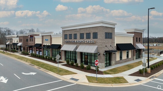
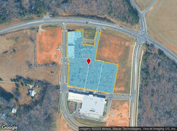
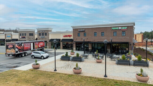
Village Xing
North
715 Music Factory Boulevard
Charlotte
L1A M71-715
Charlotte-Concord-Gastonia, NC-SC
Mecklenburg
011-073-46
North Carolina
Commercialnec
1a
2024
5.75 AC
2025
DEMOGRAPHICS near Village Xing
1 Mile
3 Mile
5 Mile
2024 Total Population
2,164
26,466
105,348
2029 Population
2,356
28,503
113,224
Pop Growth 2024-2029
+ 8.87%
+ 7.70%
+ 7.48%
Average Age
37
38
38
2024 Total Households
692
9,137
39,169
HH Growth 2024-2029
+ 8.96%
+ 7.39%
+ 7.00%
Median Household Inc
$203,966
$129,323
$110,556
Avg Household Size
3.10
2.90
2.60
2024 Avg HH Vehicles
2.00
2.00
2.00
Median Home Value
$692,982
$435,583
$406,308
Median Year Built
2010
2006
2003
Nearby Places
Map Layers
Map Styles
 Street
 Aerial
- Restaurants
- Banks
- Shops
- Fitness
- Groceries
PUBLIC TRANSPORTATION
AIRPORT
Concord-Padgett Regional
DRIVE
WALK
Distance
Concord-Padgett Regional
16 min
9.2 mi
Charlotte/Douglas International
DRIVE
WALK
Distance
Charlotte/Douglas International
38 min
26.4 mi
Freight Ports
North Charleston Terminal
DRIVE
WALK
Distance
North Charleston Terminal
250 min
218.6 mi
SALE & LEASE HISTORY
LISTING DATE
SALE/LEASE

Oct 30, 2020
For Lease
Nearby Properties
Address
Land Use
TOTAL SIZE
Lot Size
Zoning
Address
Land Use
TOTAL SIZE
Lot Size
Zoning
382,543 SF
35.81 AC
TR
Address
Land Use
TOTAL SIZE
Lot Size
Zoning
541,689 SF
60.98 AC
CB(CD)
Address
Land Use
TOTAL SIZE
Lot Size
Zoning
247,940 SF
32.28 AC
RP
Address
Land Use
TOTAL SIZE
Lot Size
Zoning
140,605 SF
33.96 AC
R
Address
Land Use
TOTAL SIZE
Lot Size
Zoning
442,024 SF
37.16 AC
CB
Address
Land Use
TOTAL SIZE
Lot Size
Zoning
26,134 SF
98.70 AC
GC
Address
Land Use
TOTAL SIZE
Lot Size
Zoning
77,612 SF
21.10 AC
NE
Address
Land Use
TOTAL SIZE
Lot Size
Zoning
81,162 SF
41.09 AC
NR
Address
Land Use
TOTAL SIZE
Lot Size
Zoning
78,300 SF
10.41 AC
SP
Address
Land Use
TOTAL SIZE
Lot Size
Zoning
193,689 SF
17.89 AC
NR
Address
Land Use
TOTAL SIZE
Lot Size
Zoning
27.28 AC
CB(CD)
Address
Land Use
TOTAL SIZE
Lot Size
Zoning
4.68 AC
Address
Land Use
TOTAL SIZE
Lot Size
Zoning
80,081 SF
21.90 AC
CB(CD)
Address
Land Use
TOTAL SIZE
Lot Size
Zoning
115,187 SF
5.94 AC
Address
Land Use
TOTAL SIZE
Lot Size
Zoning
3.52 AC
Address
Land Use
TOTAL SIZE
Lot Size
Zoning
335,928 SF
48.07 AC
IC
Address
Land Use
TOTAL SIZE
Lot Size
Zoning
1.63 AC
Address
Land Use
TOTAL SIZE
Lot Size
Zoning
2.59 AC
Address
Land Use
TOTAL SIZE
Lot Size
Zoning
15,900 SF
7.63 AC
GC
Address
Land Use
TOTAL SIZE
Lot Size
Zoning
67,717 SF
7.12 AC
NR
Address
Land Use
TOTAL SIZE
Lot Size
Zoning
3,184 SF
200.03 AC
RPA
Address
Land Use
TOTAL SIZE
Lot Size
Zoning
62,770 SF
11.86 AC
NMX(CZ)
Address
Land Use
TOTAL SIZE
Lot Size
Zoning
20,467 SF
51.68 AC
C
Address
Land Use
TOTAL SIZE
Lot Size
Zoning
80,010 SF
3.35 AC
SP
Address
Land Use
TOTAL SIZE
Lot Size
Zoning
18,960 SF
45.34 AC
SP
Address
Land Use
TOTAL SIZE
Lot Size
Zoning
Address
Land Use
TOTAL SIZE
Lot Size
Zoning
67,560 SF
5.20 AC
IC
Address
Land Use
TOTAL SIZE
Lot Size
Zoning
75,790 SF
4.12 AC
IC
Address
Land Use
TOTAL SIZE
Lot Size
Zoning
0.89 AC
Address
Land Use
TOTAL SIZE
Lot Size
Zoning
27,416 SF
2.06 AC
GC
The World's #1 Commercial Real Estate Marketplace
Connect with us
© 2026 CoStar Group
The information above has been obtained from sources believed reliable. While we do not doubt its accuracy we have not verified it and make no guarantee, warranty or representation about it. It is your responsibility to independently confirm its accuracy and completeness. Any projections, opinions, assumptions, or estimates used are for example only and do not represent the current or future performance of the property. The value of this transaction to you depends on tax and other factors which should be evaluated by your tax, financial, and legal advisors. You and your advisors should conduct a careful, independent investigation of the property to determine to your satisfaction the suitability of the property for your needs.