Property Record
Us 31, Berrien Springs, MI 49103
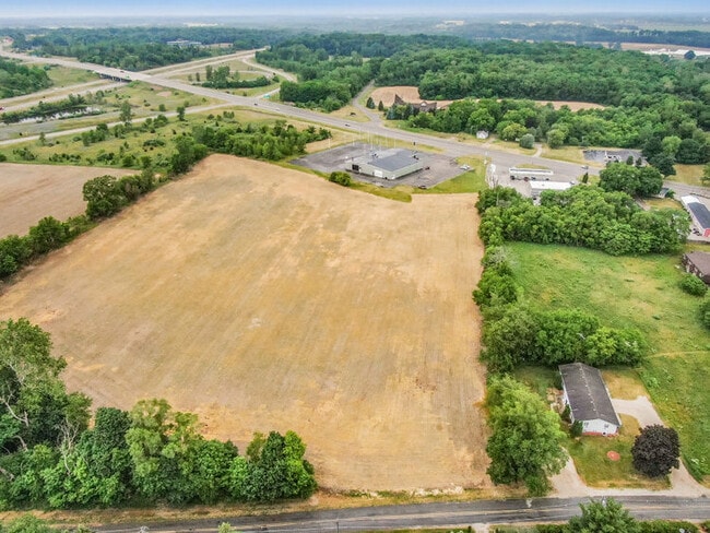
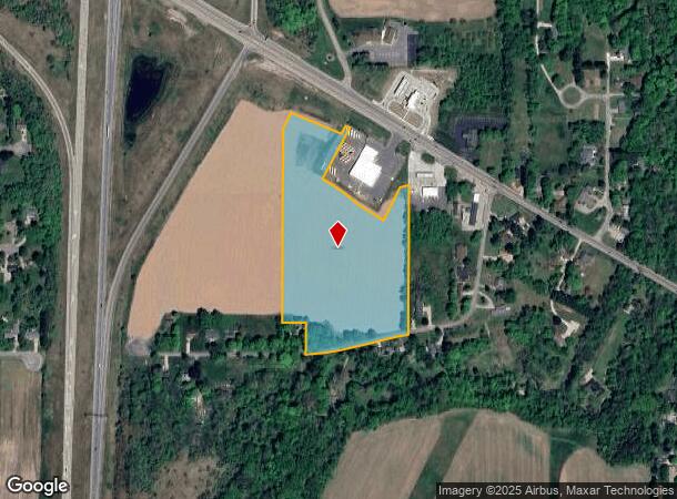
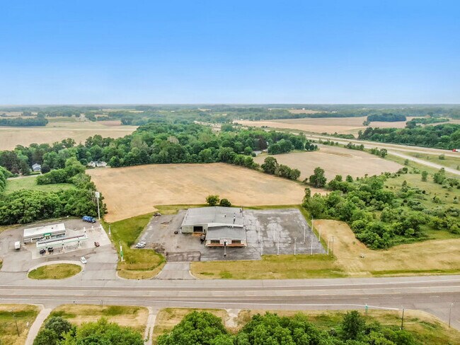
This Property Is For Sale
NEARBY LISTINGS FOR SALE OR LEASE
-
-
View all Berrien Springs listings for sale on LoopNet.com
Property Detail
Us 31
11-15-0011-0021-44-0
SPLIT/COMBINED ON 02/18/2014 FROM 15-0011-0021-31-5, 15-0011-0021-36-6; COM 124.51' N OF S QTR PST SEC 11 T6S R18W TH S76DEG44'55''W 333.08' TH SWLY 209.87' ON A 1600' RAD CUR RT CHD BRG S80DEG30'23''W 209.72' TH N00DEG01'13''W 171.89' TH S89DEG58'47
Agriculturalland
Berrien
X
Michigan
26021C0253C
14.04 AC
2024
Michigan Southwest Area
2025
Other Market Areas
021400
Niles-Benton Harbor, MI
DEMOGRAPHICS near Us 31
1 Mile
3 Mile
5 Mile
2024 Total Population
1,440
9,471
13,897
2029 Population
1,409
9,271
13,552
Pop Growth 2024-2029
(2.15%)
(2.11%)
(2.48%)
Average Age
38
39
40
2024 Total Households
489
3,319
4,979
HH Growth 2024-2029
(2.45%)
(2.44%)
(2.79%)
Median Household Inc
$51,250
$59,779
$63,632
Avg Household Size
2.30
2.40
2.50
2024 Avg HH Vehicles
2.00
2.00
2.00
Median Home Value
$206,098
$192,370
$211,839
Median Year Built
1971
1971
1973
Nearby Places
Map Layers
Map Styles
 Street
 Aerial
- Restaurants
- Banks
- Shops
- Fitness
- Groceries
PUBLIC TRANSPORTATION
AIRPORT
South Bend International
DRIVE
WALK
Distance
South Bend International
35 min
23.1 mi
Freight Ports
Port Milwaukee
DRIVE
WALK
Distance
Port Milwaukee
226 min
180.5 mi
Nearby Properties
Address
Land Use
TOTAL SIZE
Lot Size
Zoning
Address
Land Use
TOTAL SIZE
Lot Size
Zoning
Address
Land Use
TOTAL SIZE
Lot Size
Zoning
28,992 SF
5.94 AC
B
Address
Land Use
TOTAL SIZE
Lot Size
Zoning
36,571 SF
3.80 AC
R3
Address
Land Use
TOTAL SIZE
Lot Size
Zoning
53,348 SF
4.19 AC
B
Address
Land Use
TOTAL SIZE
Lot Size
Zoning
9,836 SF
36.65 AC
AR
Address
Land Use
TOTAL SIZE
Lot Size
Zoning
18,310 SF
4.84 AC
B
Address
Land Use
TOTAL SIZE
Lot Size
Zoning
47,242 SF
124.57 AC
UC
Address
Land Use
TOTAL SIZE
Lot Size
Zoning
49,056 SF
2.21 AC
R-3
Address
Land Use
TOTAL SIZE
Lot Size
Zoning
4,460 SF
105.20 AC
AGRI / RES
Address
Land Use
TOTAL SIZE
Lot Size
Zoning
4,501 SF
4.22 AC
B
Address
Land Use
TOTAL SIZE
Lot Size
Zoning
20,090 SF
2.13 AC
R3
Address
Land Use
TOTAL SIZE
Lot Size
Zoning
230.64 AC
A - AG
Address
Land Use
TOTAL SIZE
Lot Size
Zoning
41,060 SF
21.99 AC
AG- AGR
Address
Land Use
TOTAL SIZE
Lot Size
Zoning
32,798 SF
31.14 AC
Address
Land Use
TOTAL SIZE
Lot Size
Zoning
3,415 SF
78.24 AC
AR
Address
Land Use
TOTAL SIZE
Lot Size
Zoning
3,222 SF
1.06 AC
B
Address
Land Use
TOTAL SIZE
Lot Size
Zoning
950 SF
9.10 AC
I-1
Address
Land Use
TOTAL SIZE
Lot Size
Zoning
19,020 SF
2.78 AC
B
Address
Land Use
TOTAL SIZE
Lot Size
Zoning
73,188 SF
17.52 AC
M
Address
Land Use
TOTAL SIZE
Lot Size
Zoning
14,550 SF
12.91 AC
R-A RE
Address
Land Use
TOTAL SIZE
Lot Size
Zoning
13,462 SF
1.05 AC
B
Address
Land Use
TOTAL SIZE
Lot Size
Zoning
1,272 SF
138.04 AC
A - AG
Address
Land Use
TOTAL SIZE
Lot Size
Zoning
5,596 SF
145.14 AC
R-A RE
Address
Land Use
TOTAL SIZE
Lot Size
Zoning
22,813 SF
0.55 AC
C-2
Address
Land Use
TOTAL SIZE
Lot Size
Zoning
2,442 SF
85.24 AC
AG
Address
Land Use
TOTAL SIZE
Lot Size
Zoning
2,544 SF
128.07 AC
A - AG
Address
Land Use
TOTAL SIZE
Lot Size
Zoning
10,790 SF
1.26 AC
B
Address
Land Use
TOTAL SIZE
Lot Size
Zoning
13,400 SF
5.86 AC
R-1 B/C
Address
Land Use
TOTAL SIZE
Lot Size
Zoning
3,830 SF
40.73 AC
AR
Address
Land Use
TOTAL SIZE
Lot Size
Zoning
2,880 SF
78.25 AC
E1
The World's #1 Commercial Real Estate Marketplace
Connect with us
© 2026 CoStar Group
The information above has been obtained from sources believed reliable. While we do not doubt its accuracy we have not verified it and make no guarantee, warranty or representation about it. It is your responsibility to independently confirm its accuracy and completeness. Any projections, opinions, assumptions, or estimates used are for example only and do not represent the current or future performance of the property. The value of this transaction to you depends on tax and other factors which should be evaluated by your tax, financial, and legal advisors. You and your advisors should conduct a careful, independent investigation of the property to determine to your satisfaction the suitability of the property for your needs.