Property Record
Vortex Dr, New Iberia, LA 70560
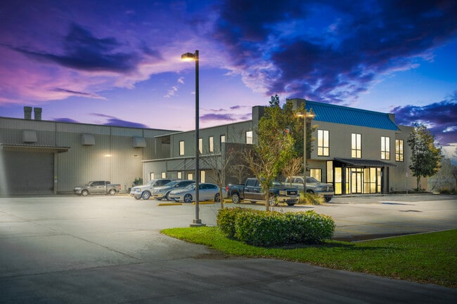
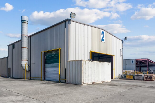
Property Detail
Vortex Dr
New Iberia, LA
5.00 AC... ITEM 2 ADMIRAL DOYLE DR, DOERLE ETAL, THOMAS, DOERLE ETAL. LOCATED IN SEC 56, T12S, R6E IMP (OFFICE / WAREHOUSE BL
0102338074R
IBERIA
Agriculturalland
Louisiana
B and X Area of moderate flood hazard, usually the area between the limits of the 100-year and 500-year floods.
4.77 AC
2025
Louisiana South Area
2025
Other Market Areas
030301
NEARBY LISTINGS FOR SALE OR LEASE
DEMOGRAPHICS near Vortex Dr
1 mile
3 mile
5 mile
2025 Total Population
252
15,154
39,220
2030 Population
254
15,032
38,538
Pop Growth 2025-2030
+ 0.79%
(0.81%)
(1.74%)
Average Age
38
39
40
2025 Total Households
94
5,730
15,446
HH Growth 2025-2030
+ 1.06%
(0.75%)
(1.74%)
Median Household Inc
$55,000
$36,698
$49,028
Avg Household Size
2.60
2.50
2.40
2025 Avg HH Vehicles
2.00
2.00
2.00
Median Home Value
$254,545
$140,480
$145,853
Median Year Built
2003
1977
1975
Nearby Places
Map Layers
Map Styles
 Street
 Aerial
Layers
 Traffic
 Biking
Places
Listings with unknown addresses are not visible on the map
- Restaurants
- Banks
- Shops
- Fitness
- Groceries
PUBLIC TRANSPORTATION
COMMUTER RAIL
New Iberia Amtrak (Sunset Limited - Amtrak)
Drive
Walk
Distance
New Iberia Amtrak (Sunset Limited - Amtrak)
7 min
3.7 mi
AIRPORT
Lafayette Regional/Paul Fournet Field
Drive
Walk
Distance
Lafayette Regional/Paul Fournet Field
27 min
17.5 mi
Freight Ports
Port of Iberia
Drive
Walk
Distance
Port of Iberia
17 min
7.9 mi
SALE & LEASE HISTORY
LISTING DATE
SALE/LEASE

Sep 17, 2024
For Sale
Nearby Properties
Address
Land Use
TOTAL SIZE
Lot Size
Zoning
Address
Land Use
TOTAL SIZE
Lot Size
Zoning
Address
Land Use
TOTAL SIZE
Lot Size
Zoning
Address
Land Use
TOTAL SIZE
Lot Size
Zoning
Address
Land Use
TOTAL SIZE
Lot Size
Zoning
1,431.20 AC
Address
Land Use
TOTAL SIZE
Lot Size
Zoning
Address
Land Use
TOTAL SIZE
Lot Size
Zoning
Address
Land Use
TOTAL SIZE
Lot Size
Zoning
Address
Land Use
TOTAL SIZE
Lot Size
Zoning
Address
Land Use
TOTAL SIZE
Lot Size
Zoning
Address
Land Use
TOTAL SIZE
Lot Size
Zoning
Address
Land Use
TOTAL SIZE
Lot Size
Zoning
Address
Land Use
TOTAL SIZE
Lot Size
Zoning
69.37 AC
Address
Land Use
TOTAL SIZE
Lot Size
Zoning
62.50 AC
Address
Land Use
TOTAL SIZE
Lot Size
Zoning
Address
Land Use
TOTAL SIZE
Lot Size
Zoning
Address
Land Use
TOTAL SIZE
Lot Size
Zoning
Address
Land Use
TOTAL SIZE
Lot Size
Zoning
Address
Land Use
TOTAL SIZE
Lot Size
Zoning
Address
Land Use
TOTAL SIZE
Lot Size
Zoning
Address
Land Use
TOTAL SIZE
Lot Size
Zoning
Address
Land Use
TOTAL SIZE
Lot Size
Zoning
17.07 AC
Address
Land Use
TOTAL SIZE
Lot Size
Zoning
Address
Land Use
TOTAL SIZE
Lot Size
Zoning
Address
Land Use
TOTAL SIZE
Lot Size
Zoning
Address
Land Use
TOTAL SIZE
Lot Size
Zoning
Address
Land Use
TOTAL SIZE
Lot Size
Zoning
Address
Land Use
TOTAL SIZE
Lot Size
Zoning
Address
Land Use
TOTAL SIZE
Lot Size
Zoning
11,250 SF
10.61 AC
Address
Land Use
TOTAL SIZE
Lot Size
Zoning
282.01 AC
Address
Land Use
TOTAL SIZE
Lot Size
Zoning
The World's #1 Commercial Real Estate Marketplace
Connect with us
© 2026 CoStar Group
The information above has been obtained from sources believed reliable. While we do not doubt its accuracy we have not verified it and make no guarantee, warranty or representation about it. It is your responsibility to independently confirm its accuracy and completeness. Any projections, opinions, assumptions, or estimates used are for example only and do not represent the current or future performance of the property. The value of this transaction to you depends on tax and other factors which should be evaluated by your tax, financial, and legal advisors. You and your advisors should conduct a careful, independent investigation of the property to determine to your satisfaction the suitability of the property for your needs.