Property Record
2195 S Presidents Dr, West Valley City, UT 84120
Current Lease Availabilities
Industrial LEASE
$8.16 SF/YR
12,147 SF
NEARBY LISTINGS FOR SALE OR LEASE
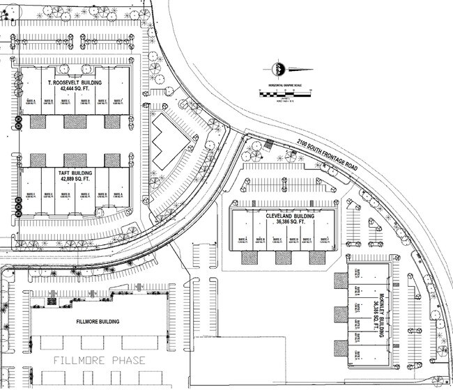
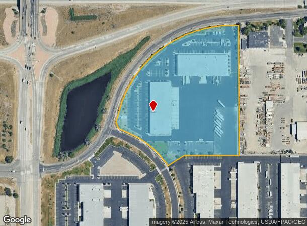
Property Detail
2195 S Presidents Dr
Salt Lake City, UT
Sd Sub
15-20-102-003-0000
LOT 401, PRESIDENTIAL BUSINESS CENTER PHASE 4. LESS & EXCEPT, BEG AT THE WLY MOST COR OF LOT 401, OF SD SUB; SD PT BEING S 000334 W 731.32 FT & W 2035.87 FT FR N 1/4 CORSEC 20, T1S, R1W, SLM; N 175305 E 12.48 FT; S 242239 E39.45 FT; N 651409 W 13.43
Multipleuses
Salt Lake
X
Utah
49035C0280E
401
2024
10.03 AC
2025
West Valley
114500
Salt Lake City
72,220 SF
DEMOGRAPHICS near 2195 S Presidents Dr
1 Mile
3 Mile
5 Mile
2024 Total Population
1,209
64,149
229,563
2029 Population
1,207
64,432
231,803
Pop Growth 2024-2029
(0.17%)
+ 0.44%
+ 0.98%
Average Age
33
35
35
2024 Total Households
331
18,861
71,576
HH Growth 2024-2029
(0.30%)
+ 0.40%
+ 1.11%
Median Household Inc
$64,346
$66,904
$66,012
Avg Household Size
3.40
3.20
3.00
2024 Avg HH Vehicles
2.00
2.00
2.00
Median Home Value
$339,285
$314,330
$328,998
Median Year Built
1969
1980
1980
Nearby Places
- Restaurants
- Banks
- Shops
- Fitness
- Groceries
PUBLIC TRANSPORTATION
COMMUTER RAIL
North Temple Station (FrontRunner - Utah Transit Authority (UTA))
DRIVE
WALK
Distance
North Temple Station (FrontRunner - Utah Transit Authority (UTA))
15 min
8.5 mi
Warm Springs Relief Point (FrontRunner - Utah Transit Authority (UTA))
DRIVE
WALK
Distance
Warm Springs Relief Point (FrontRunner - Utah Transit Authority (UTA))
16 min
9.2 mi
AIRPORT
Salt Lake City International
DRIVE
WALK
Distance
Salt Lake City International
7 min
4.6 mi
Freight Ports
Port of Stockton
DRIVE
WALK
Distance
Port of Stockton
708 min
691.1 mi
Nearby Properties
Address
Land Use
TOTAL SIZE
Lot Size
Zoning
Address
Land Use
TOTAL SIZE
Lot Size
Zoning
906,418 SF
46.97 AC
IP-M-1
Address
Land Use
TOTAL SIZE
Lot Size
Zoning
673,062 SF
15.84 AC
RM
Address
Land Use
TOTAL SIZE
Lot Size
Zoning
690,542 SF
35.75 AC
M-1
Address
Land Use
TOTAL SIZE
Lot Size
Zoning
322,076 SF
16.32 AC
PL
Address
Land Use
TOTAL SIZE
Lot Size
Zoning
432,730 SF
13.03 AC
R-M
Address
Land Use
TOTAL SIZE
Lot Size
Zoning
76,096 SF
17.30 AC
RM
Address
Land Use
TOTAL SIZE
Lot Size
Zoning
10,353 SF
143.39 AC
IP-CG
Address
Land Use
TOTAL SIZE
Lot Size
Zoning
429,554 SF
24.49 AC
M1
Address
Land Use
TOTAL SIZE
Lot Size
Zoning
505,079 SF
30.07 AC
M-1
Address
Land Use
TOTAL SIZE
Lot Size
Zoning
529,870 SF
13.35 AC
R-M
Address
Land Use
TOTAL SIZE
Lot Size
Zoning
482,870 SF
31.13 AC
M-1
Address
Land Use
TOTAL SIZE
Lot Size
Zoning
401,887 SF
3.51 AC
RM
Address
Land Use
TOTAL SIZE
Lot Size
Zoning
475,592 SF
24.09 AC
M-1
Address
Land Use
TOTAL SIZE
Lot Size
Zoning
505,079 SF
25.87 AC
M-1
Address
Land Use
TOTAL SIZE
Lot Size
Zoning
29.13 AC
C-2
Address
Land Use
TOTAL SIZE
Lot Size
Zoning
426,280 SF
19.84 AC
M1
Address
Land Use
TOTAL SIZE
Lot Size
Zoning
491,507 SF
28.48 AC
M-1
Address
Land Use
TOTAL SIZE
Lot Size
Zoning
289,725 SF
8.42 AC
1108
Address
Land Use
TOTAL SIZE
Lot Size
Zoning
491,507 SF
28.28 AC
M-1
Address
Land Use
TOTAL SIZE
Lot Size
Zoning
116,268 SF
8.07 AC
RMF-45
Address
Land Use
TOTAL SIZE
Lot Size
Zoning
436,903 SF
27.09 AC
M-1
Address
Land Use
TOTAL SIZE
Lot Size
Zoning
436,875 SF
26.95 AC
M-1
Address
Land Use
TOTAL SIZE
Lot Size
Zoning
431,400 SF
23.99 AC
IP-M-1
Address
Land Use
TOTAL SIZE
Lot Size
Zoning
5,953 SF
225.72 AC
M-1
Address
Land Use
TOTAL SIZE
Lot Size
Zoning
381,105 SF
2.88 AC
CC
Address
Land Use
TOTAL SIZE
Lot Size
Zoning
482,768 SF
22.90 AC
M-1
Address
Land Use
TOTAL SIZE
Lot Size
Zoning
750,887 SF
28 AC
M1
Address
Land Use
TOTAL SIZE
Lot Size
Zoning
304,366 SF
2.71 AC
M
Address
Land Use
TOTAL SIZE
Lot Size
Zoning
387,633 SF
24 AC
M-1
Address
Land Use
TOTAL SIZE
Lot Size
Zoning
348,300 SF
18.50 AC
M-1
The World's #1 Commercial Real Estate Marketplace
Connect with us
© 2025 CoStar Group
The information above has been obtained from sources believed reliable. While we do not doubt its accuracy we have not verified it and make no guarantee, warranty or representation about it. It is your responsibility to independently confirm its accuracy and completeness. Any projections, opinions, assumptions, or estimates used are for example only and do not represent the current or future performance of the property. The value of this transaction to you depends on tax and other factors which should be evaluated by your tax, financial, and legal advisors. You and your advisors should conduct a careful, independent investigation of the property to determine to your satisfaction the suitability of the property for your needs.