Property Record
W 255Th St, Paola, KS 66071
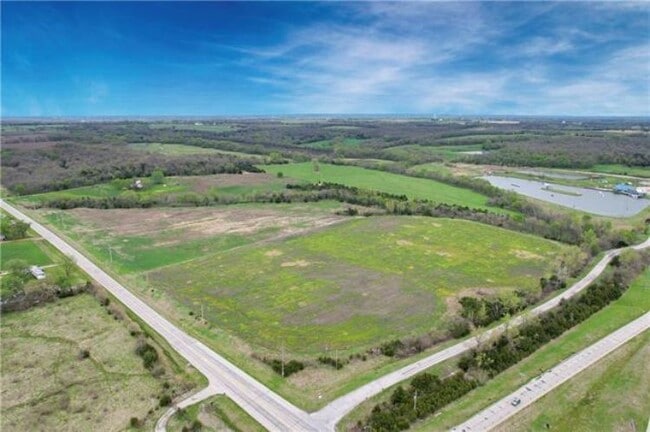

Property Detail
W 255Th St
Kansas City, MO-KS
S14, T16, R23, ACRES 20.09, NW4NE4 LESS ROW 21.05AC
086-14-0-00-00-002.00-0
MIAMI
Ranch
Kansas
A Areas with a 1% annual chance of flooding and a 26% chance of flooding over the life of a 30-year mortgage.
20.09 AC
2025
Outer South Kansas City
2025
Kansas City
100601
NEARBY LISTINGS FOR SALE OR LEASE
-
-
View all Paola listings for sale on LoopNet.com
DEMOGRAPHICS near W 255Th St
1 mile
3 mile
5 mile
2025 Total Population
129
1,359
6,130
2030 Population
133
1,399
6,386
Pop Growth 2025-2030
+ 3.10%
+ 2.94%
+ 4.18%
Average Age
45
45
40
2025 Total Households
49
506
2,200
HH Growth 2025-2030
+ 4.08%
+ 3.16%
+ 4.41%
Median Household Inc
$87,500
$92,499
$100,283
Avg Household Size
2.50
2.60
2.70
2025 Avg HH Vehicles
3.00
3.00
3.00
Median Home Value
$366,666
$383,082
$345,600
Median Year Built
1976
1981
1999
Nearby Places
Map Layers
Map Styles
 Street
 Aerial
Layers
 Traffic
 Biking
Places
Listings with unknown addresses are not visible on the map
- Restaurants
- Banks
- Shops
- Fitness
- Groceries
SALE & LEASE HISTORY
LISTING DATE
SALE/LEASE

May 10, 2022
For Sale
Nearby Properties
Address
Land Use
TOTAL SIZE
Lot Size
Zoning
Address
Land Use
TOTAL SIZE
Lot Size
Zoning
22,537 SF
18.93 AC
Address
Land Use
TOTAL SIZE
Lot Size
Zoning
27,605 SF
8.90 AC
CS
Address
Land Use
TOTAL SIZE
Lot Size
Zoning
12,562 SF
1.58 AC
CS
Address
Land Use
TOTAL SIZE
Lot Size
Zoning
28,562 SF
1.98 AC
CS
Address
Land Use
TOTAL SIZE
Lot Size
Zoning
1,800 SF
4.98 AC
C2
Address
Land Use
TOTAL SIZE
Lot Size
Zoning
9,149 SF
1.20 AC
Address
Land Use
TOTAL SIZE
Lot Size
Zoning
1.17 AC
CS
Address
Land Use
TOTAL SIZE
Lot Size
Zoning
11,410 SF
1.21 AC
I1
Address
Land Use
TOTAL SIZE
Lot Size
Zoning
4,000 SF
5.73 AC
C2
Address
Land Use
TOTAL SIZE
Lot Size
Zoning
15,680 SF
1.50 AC
Address
Land Use
TOTAL SIZE
Lot Size
Zoning
4,000 SF
1.13 AC
CS
Address
Land Use
TOTAL SIZE
Lot Size
Zoning
26.88 AC
CS
Address
Land Use
TOTAL SIZE
Lot Size
Zoning
2,432 SF
0.14 AC
CS
Address
Land Use
TOTAL SIZE
Lot Size
Zoning
5,000 SF
3.70 AC
CS
Address
Land Use
TOTAL SIZE
Lot Size
Zoning
1,036 SF
21.49 AC
Address
Land Use
TOTAL SIZE
Lot Size
Zoning
132.20 AC
AG
Address
Land Use
TOTAL SIZE
Lot Size
Zoning
3,034 SF
1.25 AC
C2
Address
Land Use
TOTAL SIZE
Lot Size
Zoning
11.38 AC
CS
Address
Land Use
TOTAL SIZE
Lot Size
Zoning
9,900 SF
2.41 AC
Address
Land Use
TOTAL SIZE
Lot Size
Zoning
4,000 SF
3.41 AC
C2
Address
Land Use
TOTAL SIZE
Lot Size
Zoning
2.36 AC
CS
Address
Land Use
TOTAL SIZE
Lot Size
Zoning
2,186 SF
4.79 AC
Address
Land Use
TOTAL SIZE
Lot Size
Zoning
3,600 SF
19.81 AC
CS
Address
Land Use
TOTAL SIZE
Lot Size
Zoning
3.67 AC
CS
Address
Land Use
TOTAL SIZE
Lot Size
Zoning
977 SF
603.35 AC
AG
Address
Land Use
TOTAL SIZE
Lot Size
Zoning
1.72 AC
CS
Address
Land Use
TOTAL SIZE
Lot Size
Zoning
5.04 AC
CS
Address
Land Use
TOTAL SIZE
Lot Size
Zoning
3,750 SF
1.44 AC
C2
Address
Land Use
TOTAL SIZE
Lot Size
Zoning
1.34 AC
CS
Address
Land Use
TOTAL SIZE
Lot Size
Zoning
4,200 SF
0.69 AC
The World's #1 Commercial Real Estate Marketplace
Connect with us
© 2026 CoStar Group
The information above has been obtained from sources believed reliable. While we do not doubt its accuracy we have not verified it and make no guarantee, warranty or representation about it. It is your responsibility to independently confirm its accuracy and completeness. Any projections, opinions, assumptions, or estimates used are for example only and do not represent the current or future performance of the property. The value of this transaction to you depends on tax and other factors which should be evaluated by your tax, financial, and legal advisors. You and your advisors should conduct a careful, independent investigation of the property to determine to your satisfaction the suitability of the property for your needs.