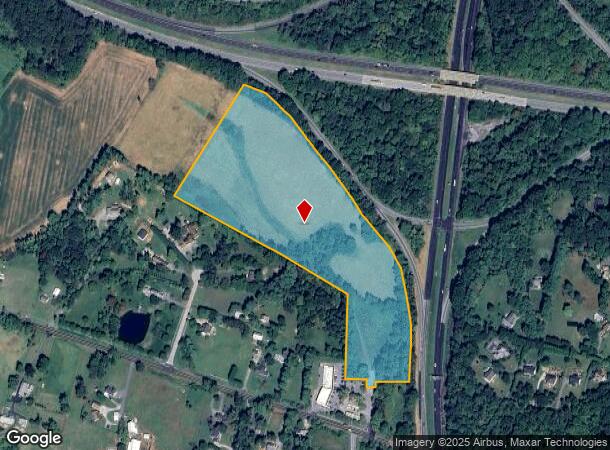
Property Record
12720 W Route 32 Rd, West Friendship, MD 21794
Current Lease Availabilities
NEARBY LISTINGS FOR SALE OR LEASE
-
-
View all West Friendship listings for lease on LoopNet.com
Property Detail
12720 W Route 32 Rd
03-289966
22.30 A. ROUTE 32 WEST FRIENDSHIP
Agriculturalland
Howard
X
Maryland
24013C0425D
22.30 AC
2024
Outlying Howard County
2025
Baltimore
603003
Baltimore-Columbia-Towson, MD
DEMOGRAPHICS near 12720 W Route 32 Rd
1 Mile
3 Mile
5 Mile
2024 Total Population
785
10,654
40,193
2029 Population
809
10,924
41,386
Pop Growth 2024-2029
+ 3.06%
+ 2.53%
+ 2.97%
Average Age
43
44
42
2024 Total Households
256
3,539
13,457
HH Growth 2024-2029
+ 3.13%
+ 2.51%
+ 3.02%
Median Household Inc
$170,122
$173,822
$158,967
Avg Household Size
3.00
2.90
2.90
2024 Avg HH Vehicles
2.00
2.00
2.00
Median Home Value
$765,822
$757,785
$713,863
Median Year Built
1990
1989
1993
Nearby Places
- Restaurants
- Banks
- Shops
- Fitness
- Groceries
PUBLIC TRANSPORTATION
AIRPORT
Baltimore/Washington International Thurgood Marshall
DRIVE
WALK
Distance
Baltimore/Washington International Thurgood Marshall
33 min
23.0 mi
Freight Ports
Port of Baltimore
DRIVE
WALK
Distance
Port of Baltimore
34 min
23.5 mi
Nearby Properties
Address
Land Use
TOTAL SIZE
Lot Size
Zoning
Address
Land Use
TOTAL SIZE
Lot Size
Zoning
310,700 SF
35.82 AC
RRDEO
Address
Land Use
TOTAL SIZE
Lot Size
Zoning
793.07 AC
RCDEO
Address
Land Use
TOTAL SIZE
Lot Size
Zoning
78,366 SF
43.23 AC
RCDEO
Address
Land Use
TOTAL SIZE
Lot Size
Zoning
106,736 SF
30.05 AC
RRDEO
Address
Land Use
TOTAL SIZE
Lot Size
Zoning
45,823 SF
38.23 AC
RCDEO
Address
Land Use
TOTAL SIZE
Lot Size
Zoning
58,430 SF
40.40 AC
R20
Address
Land Use
TOTAL SIZE
Lot Size
Zoning
10,660 SF
66.10 AC
RCDEO
Address
Land Use
TOTAL SIZE
Lot Size
Zoning
13,780 SF
239.78 AC
RCDEO
Address
Land Use
TOTAL SIZE
Lot Size
Zoning
8,900 SF
21.90 AC
B2
Address
Land Use
TOTAL SIZE
Lot Size
Zoning
1,680 SF
74.35 AC
RCDEO
Address
Land Use
TOTAL SIZE
Lot Size
Zoning
49,600 SF
5.74 AC
RRDEO
Address
Land Use
TOTAL SIZE
Lot Size
Zoning
36,361 SF
6.07 AC
RRDEO
Address
Land Use
TOTAL SIZE
Lot Size
Zoning
2,755 SF
184.93 AC
RRDEO
Address
Land Use
TOTAL SIZE
Lot Size
Zoning
7,400 SF
65 AC
RCDEO
Address
Land Use
TOTAL SIZE
Lot Size
Zoning
576 SF
72.40 AC
RCDEO
Address
Land Use
TOTAL SIZE
Lot Size
Zoning
1,685 SF
9.07 AC
RRDEO
Address
Land Use
TOTAL SIZE
Lot Size
Zoning
4,529 SF
86.92 AC
RCDEO
Address
Land Use
TOTAL SIZE
Lot Size
Zoning
12,595 SF
5.06 AC
RRDEO
Address
Land Use
TOTAL SIZE
Lot Size
Zoning
10,000 SF
17.16 AC
RCDEO
Address
Land Use
TOTAL SIZE
Lot Size
Zoning
960 SF
100.87 AC
RCDEO
Address
Land Use
TOTAL SIZE
Lot Size
Zoning
2,638 SF
50 AC
RRDEO
Address
Land Use
TOTAL SIZE
Lot Size
Zoning
37.06 AC
B2
Address
Land Use
TOTAL SIZE
Lot Size
Zoning
7,600 SF
4.64 AC
B2
Address
Land Use
TOTAL SIZE
Lot Size
Zoning
23,000 SF
4 AC
B2
Address
Land Use
TOTAL SIZE
Lot Size
Zoning
2,488 SF
6.55 AC
B2
Address
Land Use
TOTAL SIZE
Lot Size
Zoning
10,386 SF
3.46 AC
RRDEO
Address
Land Use
TOTAL SIZE
Lot Size
Zoning
9,560 SF
3 AC
RCDEO
Address
Land Use
TOTAL SIZE
Lot Size
Zoning
40.50 AC
RCDEO
Address
Land Use
TOTAL SIZE
Lot Size
Zoning
3,968 SF
1.98 AC
B2
Address
Land Use
TOTAL SIZE
Lot Size
Zoning
6,094 SF
2.63 AC
RCDEO
The World's #1 Commercial Real Estate Marketplace
Connect with us
© 2025 CoStar Group
The information above has been obtained from sources believed reliable. While we do not doubt its accuracy we have not verified it and make no guarantee, warranty or representation about it. It is your responsibility to independently confirm its accuracy and completeness. Any projections, opinions, assumptions, or estimates used are for example only and do not represent the current or future performance of the property. The value of this transaction to you depends on tax and other factors which should be evaluated by your tax, financial, and legal advisors. You and your advisors should conduct a careful, independent investigation of the property to determine to your satisfaction the suitability of the property for your needs.