Property Record
3998 N Buffalo Dr, Las Vegas, NV 89129
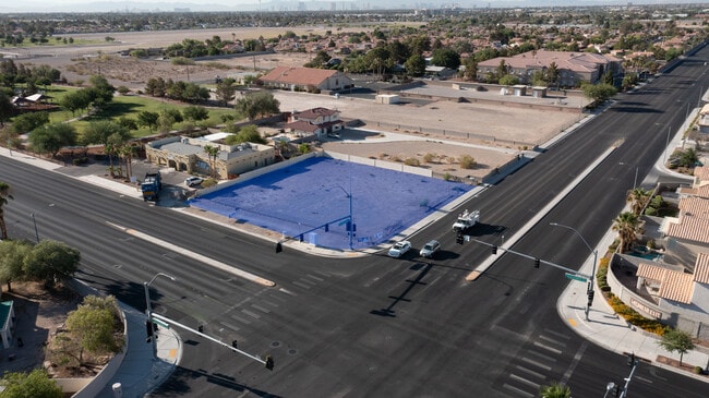

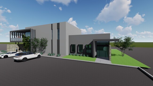
Property Detail
3998 N Buffalo Dr
Las Vegas-Henderson-North Las Vegas, NV
PARCEL MAP FILE 31 PAGE 94 LOT 1
138-10-101-001
CLARK
Vacantlandnec
Nevada
RE
1
B and X Area of moderate flood hazard, usually the area between the limits of the 100-year and 500-year floods.
0.46 AC
2026
Northwest Las Vegas
2026
Las Vegas
003411
NEARBY LISTINGS FOR SALE OR LEASE
DEMOGRAPHICS near 3998 N Buffalo Dr
1 mile
3 mile
5 mile
2025 Total Population
19,274
139,896
405,489
2030 Population
20,127
146,465
424,941
Pop Growth 2025-2030
+ 4.43%
+ 4.70%
+ 4.80%
Average Age
41
43
41
2025 Total Households
7,238
54,401
152,365
HH Growth 2025-2030
+ 4.50%
+ 4.75%
+ 4.86%
Median Household Inc
$79,844
$81,373
$80,347
Avg Household Size
2.60
2.50
2.60
2025 Avg HH Vehicles
2.00
2.00
2.00
Median Home Value
$434,738
$445,064
$430,731
Median Year Built
1995
1993
1995
Nearby Places
Map Layers
Map Styles
 Street
 Aerial
Layers
 Traffic
 Biking
Places
Listings with unknown addresses are not visible on the map
- Restaurants
- Banks
- Shops
- Fitness
- Groceries
PUBLIC TRANSPORTATION
AIRPORT
Harry Reid International
Drive
Walk
Distance
Harry Reid International
27 min
14.7 mi
Boulder City Municipal
Drive
Walk
Distance
Boulder City Municipal
47 min
36.5 mi
SALE & LEASE HISTORY
LISTING DATE
SALE/LEASE

Jul 14, 2022
For Sale
Nearby Properties
Address
Land Use
TOTAL SIZE
Lot Size
Zoning
Address
Land Use
TOTAL SIZE
Lot Size
Zoning
647,754 SF
38.57 AC
C2
Address
Land Use
TOTAL SIZE
Lot Size
Zoning
161.14 AC
CV
Address
Land Use
TOTAL SIZE
Lot Size
Zoning
5,643 SF
10.29 AC
Address
Land Use
TOTAL SIZE
Lot Size
Zoning
37.31 AC
CV
Address
Land Use
TOTAL SIZE
Lot Size
Zoning
7,148 SF
7.26 AC
Address
Land Use
TOTAL SIZE
Lot Size
Zoning
14,793 SF
9.57 AC
CPB
Address
Land Use
TOTAL SIZE
Lot Size
Zoning
263,881 SF
7.49 AC
R-4
Address
Land Use
TOTAL SIZE
Lot Size
Zoning
5,750 SF
19.67 AC
R3
Address
Land Use
TOTAL SIZE
Lot Size
Zoning
21.12 AC
RE
Address
Land Use
TOTAL SIZE
Lot Size
Zoning
4,084 SF
1.84 AC
CPB
Address
Land Use
TOTAL SIZE
Lot Size
Zoning
178,800 SF
16.79 AC
TC
Address
Land Use
TOTAL SIZE
Lot Size
Zoning
132,309 SF
12.45 AC
L:T-C
Address
Land Use
TOTAL SIZE
Lot Size
Zoning
3,618 SF
10 AC
L:R-3
Address
Land Use
TOTAL SIZE
Lot Size
Zoning
99,487 SF
22.61 AC
PC
Address
Land Use
TOTAL SIZE
Lot Size
Zoning
7,103 SF
14.27 AC
L:R-3
Address
Land Use
TOTAL SIZE
Lot Size
Zoning
196,873 SF
5.25 AC
C2
Address
Land Use
TOTAL SIZE
Lot Size
Zoning
105,205 SF
18.86 AC
TC
Address
Land Use
TOTAL SIZE
Lot Size
Zoning
4,273 SF
16.04 AC
Address
Land Use
TOTAL SIZE
Lot Size
Zoning
4,273 SF
15.06 AC
Address
Land Use
TOTAL SIZE
Lot Size
Zoning
18.02 AC
PF
Address
Land Use
TOTAL SIZE
Lot Size
Zoning
267,271 SF
22.36 AC
C1
Address
Land Use
TOTAL SIZE
Lot Size
Zoning
6,020 SF
10.30 AC
PC
Address
Land Use
TOTAL SIZE
Lot Size
Zoning
48,060 SF
7.25 AC
CPB
Address
Land Use
TOTAL SIZE
Lot Size
Zoning
7,427 SF
4.56 AC
R3
Address
Land Use
TOTAL SIZE
Lot Size
Zoning
9,789 SF
2.10 AC
R3
Address
Land Use
TOTAL SIZE
Lot Size
Zoning
117,088 SF
5.49 AC
Address
Land Use
TOTAL SIZE
Lot Size
Zoning
5,718 SF
5.94 AC
R3
Address
Land Use
TOTAL SIZE
Lot Size
Zoning
2,618 SF
13.32 AC
L:R-3
Address
Land Use
TOTAL SIZE
Lot Size
Zoning
18.70 AC
PC
The World's #1 Commercial Real Estate Marketplace
Connect with us
© 2026 CoStar Group
The information above has been obtained from sources believed reliable. While we do not doubt its accuracy we have not verified it and make no guarantee, warranty or representation about it. It is your responsibility to independently confirm its accuracy and completeness. Any projections, opinions, assumptions, or estimates used are for example only and do not represent the current or future performance of the property. The value of this transaction to you depends on tax and other factors which should be evaluated by your tax, financial, and legal advisors. You and your advisors should conduct a careful, independent investigation of the property to determine to your satisfaction the suitability of the property for your needs.