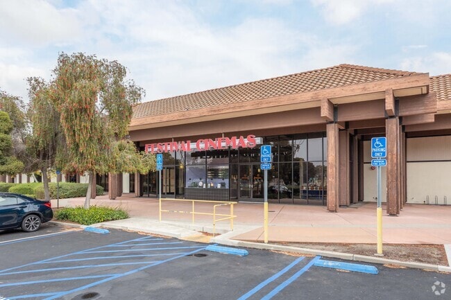
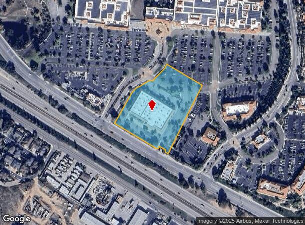
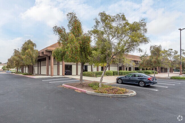
Property Record
W Branch St, Arroyo Grande, CA 93420
NEARBY LISTINGS FOR SALE OR LEASE
Property Detail
W Branch St
007-787-020
CY AG PM 74/09-11 PTN PAR B
Theater
San Luis Obispo
X
California
06079C1363J
3.87 AC
2024
South 101 Corridor
2025
San Luis Obispo/Paso Robles
011901
San Luis Obispo-Paso Robles-Arroyo Grande, CA
DEMOGRAPHICS near W Branch St
1 Mile
3 Mile
5 Mile
2024 Total Population
11,286
47,058
54,323
2029 Population
11,275
46,993
54,246
Pop Growth 2024-2029
(0.10%)
(0.14%)
(0.14%)
Average Age
43
44
44
2024 Total Households
4,619
19,147
22,278
HH Growth 2024-2029
(0.35%)
(0.23%)
(0.18%)
Median Household Inc
$89,079
$83,226
$85,302
Avg Household Size
2.40
2.40
2.40
2024 Avg HH Vehicles
2.00
2.00
2.00
Median Home Value
$743,848
$743,061
$766,824
Median Year Built
1982
1980
1981
Nearby Places
Map Layers
Map Styles
 Street
 Aerial
- Restaurants
- Banks
- Shops
- Fitness
- Groceries
PUBLIC TRANSPORTATION
COMMUTER RAIL
Grover Beach Amtrak (Pacific Surfliner - Amtrak)
DRIVE
WALK
Distance
Grover Beach Amtrak (Pacific Surfliner - Amtrak)
6 min
3.0 mi
AIRPORT
San Luis County Regional
DRIVE
WALK
Distance
San Luis County Regional
17 min
10.0 mi
Freight Ports
The Port of Hueneme
DRIVE
WALK
Distance
The Port of Hueneme
154 min
118.6 mi
Nearby Properties
Address
Land Use
TOTAL SIZE
Lot Size
Zoning
Address
Land Use
TOTAL SIZE
Lot Size
Zoning
94,017 SF
1.45 AC
CD
Address
Land Use
TOTAL SIZE
Lot Size
Zoning
52,717 SF
6.30 AC
VR
Address
Land Use
TOTAL SIZE
Lot Size
Zoning
149,488 SF
14.90 AC
Address
Land Use
TOTAL SIZE
Lot Size
Zoning
84,460 SF
4.12 AC
RRH
Address
Land Use
TOTAL SIZE
Lot Size
Zoning
1.20 AC
Address
Land Use
TOTAL SIZE
Lot Size
Zoning
66,455 SF
22.18 AC
GC
Address
Land Use
TOTAL SIZE
Lot Size
Zoning
21,865 SF
1.10 AC
C2
Address
Land Use
TOTAL SIZE
Lot Size
Zoning
85,866 SF
7.18 AC
GC
Address
Land Use
TOTAL SIZE
Lot Size
Zoning
74,553 SF
6.14 AC
CBD
Address
Land Use
TOTAL SIZE
Lot Size
Zoning
44,067 SF
2.38 AC
O
Address
Land Use
TOTAL SIZE
Lot Size
Zoning
99,676 SF
3.12 AC
RC
Address
Land Use
TOTAL SIZE
Lot Size
Zoning
816 SF
4.09 AC
CPC
Address
Land Use
TOTAL SIZE
Lot Size
Zoning
55,156 SF
6.88 AC
CG
Address
Land Use
TOTAL SIZE
Lot Size
Zoning
1,464 SF
3.62 AC
CS
Address
Land Use
TOTAL SIZE
Lot Size
Zoning
75,066 SF
1.11 AC
R4
Address
Land Use
TOTAL SIZE
Lot Size
Zoning
5,264 SF
7.91 AC
RMF
Address
Land Use
TOTAL SIZE
Lot Size
Zoning
2.60 AC
R3
Address
Land Use
TOTAL SIZE
Lot Size
Zoning
43,040 SF
3.08 AC
PC
Address
Land Use
TOTAL SIZE
Lot Size
Zoning
34,122 SF
7.68 AC
GC
Address
Land Use
TOTAL SIZE
Lot Size
Zoning
5,993 SF
1.17 AC
R4
Address
Land Use
TOTAL SIZE
Lot Size
Zoning
86,620 SF
6.40 AC
PD
Address
Land Use
TOTAL SIZE
Lot Size
Zoning
4.82 AC
R4
Address
Land Use
TOTAL SIZE
Lot Size
Zoning
62,984 SF
1.50 AC
GC
Address
Land Use
TOTAL SIZE
Lot Size
Zoning
56,280 SF
2.28 AC
Address
Land Use
TOTAL SIZE
Lot Size
Zoning
36,054 SF
2.90 AC
CRS
Address
Land Use
TOTAL SIZE
Lot Size
Zoning
3.22 AC
GC
Address
Land Use
TOTAL SIZE
Lot Size
Zoning
10.50 AC
PF
Address
Land Use
TOTAL SIZE
Lot Size
Zoning
28,215 SF
2.81 AC
GC
Address
Land Use
TOTAL SIZE
Lot Size
Zoning
4.77 AC
CR
Address
Land Use
TOTAL SIZE
Lot Size
Zoning
31,565 SF
2.01 AC
VC
The World's #1 Commercial Real Estate Marketplace
Connect with us
© 2025 CoStar Group
The information above has been obtained from sources believed reliable. While we do not doubt its accuracy we have not verified it and make no guarantee, warranty or representation about it. It is your responsibility to independently confirm its accuracy and completeness. Any projections, opinions, assumptions, or estimates used are for example only and do not represent the current or future performance of the property. The value of this transaction to you depends on tax and other factors which should be evaluated by your tax, financial, and legal advisors. You and your advisors should conduct a careful, independent investigation of the property to determine to your satisfaction the suitability of the property for your needs.