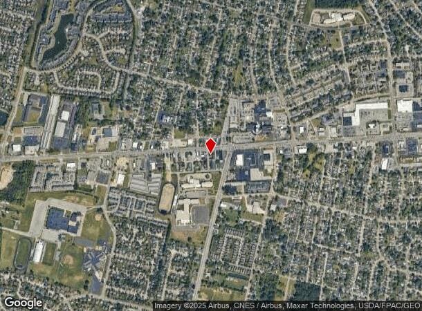
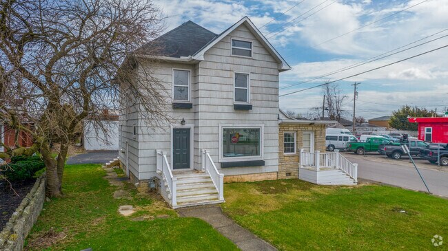
Property Record
1846 W Decatur St, Flushing, NY 11385

NEARBY LISTINGS FOR SALE OR LEASE
Property Detail
1846 W Decatur St
Columbus, OH
Rome
240-006774
5255 W BROAD ST VILLAGE OF ROME LOT 20 EX IRR NE
Storemultistory
Franklin
X
Ohio
39097C0200E
20
2024
0.15 AC
2024
Southwest
008120
Columbus
1,764 SF
DEMOGRAPHICS near 1846 W Decatur St
1 Mile
3 Mile
5 Mile
2024 Total Population
17,770
86,408
194,218
2029 Population
17,591
86,111
194,472
Pop Growth 2024-2029
(1.01%)
(0.34%)
+ 0.13%
Average Age
37
35
36
2024 Total Households
7,190
33,800
74,586
HH Growth 2024-2029
(1.00%)
(0.46%)
+ 0.05%
Median Household Inc
$57,482
$59,609
$66,093
Avg Household Size
2.40
2.50
2.50
2024 Avg HH Vehicles
2.00
2.00
2.00
Median Home Value
$162,994
$193,221
$208,216
Median Year Built
1973
1986
1985
Nearby Places
Map Layers
Map Styles
 Street
 Aerial
- Restaurants
- Banks
- Shops
- Fitness
- Groceries
PUBLIC TRANSPORTATION
AIRPORT
John Glenn Columbus International
DRIVE
WALK
Distance
John Glenn Columbus International
19 min
16.5 mi
Freight Ports
Port of Baltimore
DRIVE
WALK
Distance
Port of Baltimore
1 min
351.5 mi
SALE & LEASE HISTORY
LISTING DATE
SALE/LEASE

Sep 29, 2016
For Sale
Sep 24, 2016
For Sale
Nov 05, 2020
For Sale
Jul 26, 2018
For Sale
Nearby Properties
Address
Land Use
TOTAL SIZE
Lot Size
Zoning
Address
Land Use
TOTAL SIZE
Lot Size
Zoning
1,215,421 SF
108.07 AC
Address
Land Use
TOTAL SIZE
Lot Size
Zoning
269,165 SF
7 AC
Address
Land Use
TOTAL SIZE
Lot Size
Zoning
961,554 SF
75.09 AC
Address
Land Use
TOTAL SIZE
Lot Size
Zoning
257,723 SF
38.06 AC
Address
Land Use
TOTAL SIZE
Lot Size
Zoning
538,680 SF
32.49 AC
Address
Land Use
TOTAL SIZE
Lot Size
Zoning
472,671 SF
70.36 AC
Address
Land Use
TOTAL SIZE
Lot Size
Zoning
155,280 SF
9.42 AC
Address
Land Use
TOTAL SIZE
Lot Size
Zoning
1,011,597 SF
49.94 AC
Address
Land Use
TOTAL SIZE
Lot Size
Zoning
566,334 SF
58.62 AC
Address
Land Use
TOTAL SIZE
Lot Size
Zoning
25,368 SF
27.23 AC
Address
Land Use
TOTAL SIZE
Lot Size
Zoning
96,602 SF
10.78 AC
Address
Land Use
TOTAL SIZE
Lot Size
Zoning
24,736 SF
29.55 AC
Address
Land Use
TOTAL SIZE
Lot Size
Zoning
247,354 SF
30.38 AC
Address
Land Use
TOTAL SIZE
Lot Size
Zoning
143.78 AC
Address
Land Use
TOTAL SIZE
Lot Size
Zoning
293,744 SF
20.12 AC
Address
Land Use
TOTAL SIZE
Lot Size
Zoning
157,875 SF
8.51 AC
Address
Land Use
TOTAL SIZE
Lot Size
Zoning
62,400 SF
9.02 AC
Address
Land Use
TOTAL SIZE
Lot Size
Zoning
332,176 SF
24.52 AC
Address
Land Use
TOTAL SIZE
Lot Size
Zoning
759,600 SF
23.75 AC
Address
Land Use
TOTAL SIZE
Lot Size
Zoning
131,116 SF
15.30 AC
Address
Land Use
TOTAL SIZE
Lot Size
Zoning
202,330 SF
18.89 AC
Address
Land Use
TOTAL SIZE
Lot Size
Zoning
117,389 SF
177.98 AC
Address
Land Use
TOTAL SIZE
Lot Size
Zoning
178,452 SF
34.84 AC
Address
Land Use
TOTAL SIZE
Lot Size
Zoning
18,823 SF
14.73 AC
Address
Land Use
TOTAL SIZE
Lot Size
Zoning
72,320 SF
2.52 AC
Address
Land Use
TOTAL SIZE
Lot Size
Zoning
249,644 SF
7.15 AC
Address
Land Use
TOTAL SIZE
Lot Size
Zoning
52,283 SF
19.41 AC
Address
Land Use
TOTAL SIZE
Lot Size
Zoning
84,002 SF
4.08 AC
Address
Land Use
TOTAL SIZE
Lot Size
Zoning
55,758 SF
7.83 AC
Address
Land Use
TOTAL SIZE
Lot Size
Zoning
121,403 SF
50.93 AC
The World's #1 Commercial Real Estate Marketplace
Connect with us
© 2025 CoStar Group
The information above has been obtained from sources believed reliable. While we do not doubt its accuracy we have not verified it and make no guarantee, warranty or representation about it. It is your responsibility to independently confirm its accuracy and completeness. Any projections, opinions, assumptions, or estimates used are for example only and do not represent the current or future performance of the property. The value of this transaction to you depends on tax and other factors which should be evaluated by your tax, financial, and legal advisors. You and your advisors should conduct a careful, independent investigation of the property to determine to your satisfaction the suitability of the property for your needs.