Property Record
W Butler Rd, Greenville, SC 29607

Property Detail
W Butler Rd
Greenville-Anderson-Greer, SC
MAP M008.02; 1
M008.02-01-005.00
GREENVILLE
Residentialacreage
South Carolina
RS
005.00
B and X Area of moderate flood hazard, usually the area between the limits of the 100-year and 500-year floods.
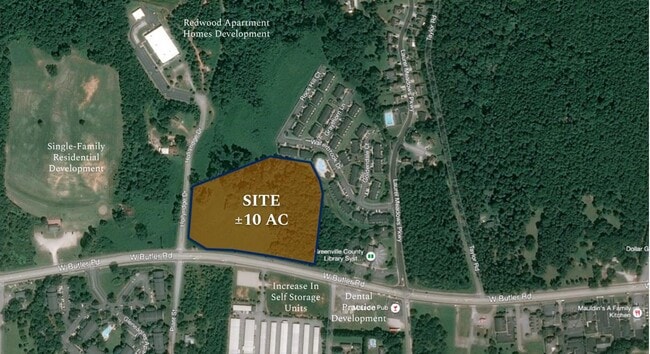
9.83 AC
2025
Mauldin/Fountain
2025
Greenville/Spartanburg
001900
NEARBY LISTINGS FOR SALE OR LEASE
DEMOGRAPHICS near W Butler Rd
1 mile
3 mile
5 mile
2025 Total Population
4,460
43,292
128,760
2030 Population
4,815
47,149
139,588
Pop Growth 2025-2030
+ 7.96%
+ 8.91%
+ 8.41%
Average Age
40
39
39
2025 Total Households
1,899
18,197
53,432
HH Growth 2025-2030
+ 8.21%
+ 9.08%
+ 8.61%
Median Household Inc
$73,933
$76,303
$81,135
Avg Household Size
2.30
2.30
2.40
2025 Avg HH Vehicles
2.00
2.00
2.00
Median Home Value
$280,019
$260,974
$316,248
Median Year Built
1996
1997
1995
Nearby Places
Map Layers
Map Styles
 Street
 Aerial
Layers
 Traffic
 Biking
Places
Listings with unknown addresses are not visible on the map
- Restaurants
- Banks
- Shops
- Fitness
- Groceries
PUBLIC TRANSPORTATION
COMMUTER RAIL
Greenville Amtrak Station (Crescent - Amtrak)
Drive
Walk
Distance
Greenville Amtrak Station (Crescent - Amtrak)
19 min
8.7 mi
AIRPORT
Greenville Spartanburg International
Drive
Walk
Distance
Greenville Spartanburg International
23 min
13.9 mi
Freight Ports
North Charleston Terminal
Drive
Walk
Distance
North Charleston Terminal
218 min
195.1 mi
SALE & LEASE HISTORY
LISTING DATE
SALE/LEASE

Sep 28, 2017
For Sale
Sep 24, 2016
For Sale
Sep 14, 2021
For Sale
Oct 19, 2016
For Sale
Nearby Properties
Address
Land Use
TOTAL SIZE
Lot Size
Zoning
Address
Land Use
TOTAL SIZE
Lot Size
Zoning
333.78 AC
S-1,I-1
Address
Land Use
TOTAL SIZE
Lot Size
Zoning
15.82 AC
RM
Address
Land Use
TOTAL SIZE
Lot Size
Zoning
54.35 AC
I-1
Address
Land Use
TOTAL SIZE
Lot Size
Zoning
10.20 AC
R12
Address
Land Use
TOTAL SIZE
Lot Size
Zoning
10.29 AC
S1
Address
Land Use
TOTAL SIZE
Lot Size
Zoning
12.95 AC
RM3
Address
Land Use
TOTAL SIZE
Lot Size
Zoning
3.38 AC
S1
Address
Land Use
TOTAL SIZE
Lot Size
Zoning
9.10 AC
RM,C2
Address
Land Use
TOTAL SIZE
Lot Size
Zoning
20.30 AC
I1
Address
Land Use
TOTAL SIZE
Lot Size
Zoning
31.81 AC
R6
Address
Land Use
TOTAL SIZE
Lot Size
Zoning
12.31 AC
Address
Land Use
TOTAL SIZE
Lot Size
Zoning
10.36 AC
R12
Address
Land Use
TOTAL SIZE
Lot Size
Zoning
3.24 AC
S1
Address
Land Use
TOTAL SIZE
Lot Size
Zoning
12.03 AC
RM2
Address
Land Use
TOTAL SIZE
Lot Size
Zoning
15.14 AC
I1
Address
Land Use
TOTAL SIZE
Lot Size
Zoning
26.75 AC
S1
Address
Land Use
TOTAL SIZE
Lot Size
Zoning
11.91 AC
RM20
Address
Land Use
TOTAL SIZE
Lot Size
Zoning
21.33 AC
Address
Land Use
TOTAL SIZE
Lot Size
Zoning
108.12 AC
I1
Address
Land Use
TOTAL SIZE
Lot Size
Zoning
19.33 AC
S1
Address
Land Use
TOTAL SIZE
Lot Size
Zoning
40.92 AC
S1
Address
Land Use
TOTAL SIZE
Lot Size
Zoning
10.78 AC
I1
Address
Land Use
TOTAL SIZE
Lot Size
Zoning
11.17 AC
C2
Address
Land Use
TOTAL SIZE
Lot Size
Zoning
5 AC
R12
Address
Land Use
TOTAL SIZE
Lot Size
Zoning
Address
Land Use
TOTAL SIZE
Lot Size
Zoning
25.70 AC
I1
Address
Land Use
TOTAL SIZE
Lot Size
Zoning
8.51 AC
S1
Address
Land Use
TOTAL SIZE
Lot Size
Zoning
55.53 AC
S1
Address
Land Use
TOTAL SIZE
Lot Size
Zoning
3.51 AC
RM2
Address
Land Use
TOTAL SIZE
Lot Size
Zoning
73.28 AC
RM3
The World's #1 Commercial Real Estate Marketplace
Connect with us
© 2026 CoStar Group
The information above has been obtained from sources believed reliable. While we do not doubt its accuracy we have not verified it and make no guarantee, warranty or representation about it. It is your responsibility to independently confirm its accuracy and completeness. Any projections, opinions, assumptions, or estimates used are for example only and do not represent the current or future performance of the property. The value of this transaction to you depends on tax and other factors which should be evaluated by your tax, financial, and legal advisors. You and your advisors should conduct a careful, independent investigation of the property to determine to your satisfaction the suitability of the property for your needs.