Property Record
W Calla Rd, New Middletown, OH 44442
NEARBY LISTINGS FOR SALE OR LEASE
-
-
View all New Middletown listings for sale on LoopNet.com
Property Detail
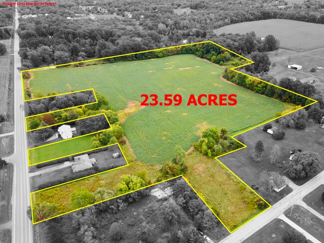
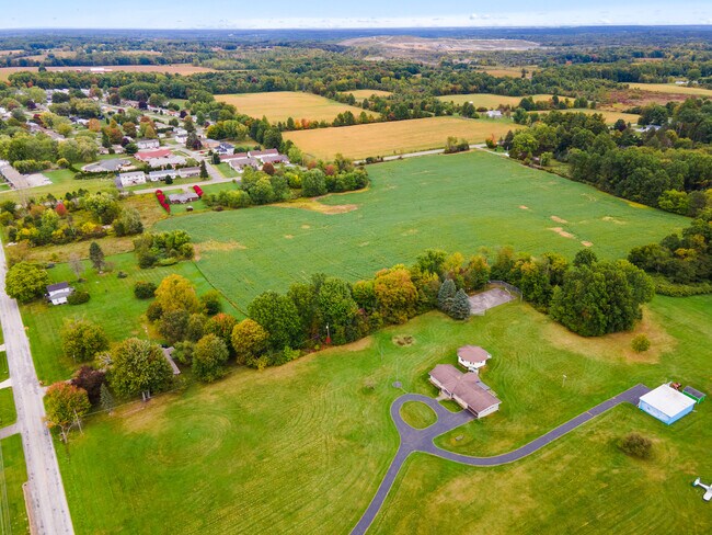
W Calla Rd
Youngstown-Warren-Boardman, OH-PA
SEC 11
01-069-0-004.00-0
Mahoning
Agriculturalland
Ohio
2024
14.24 AC
2024
Mahoning County
813601
Youngstown/Warren/Boardman
DEMOGRAPHICS near W Calla Rd
1 Mile
3 Mile
5 Mile
2024 Total Population
2,441
7,745
23,503
2029 Population
2,377
7,522
22,809
Pop Growth 2024-2029
(2.62%)
(2.88%)
(2.95%)
Average Age
47
45
46
2024 Total Households
1,048
3,139
9,931
HH Growth 2024-2029
(2.67%)
(2.96%)
(2.99%)
Median Household Inc
$57,962
$70,269
$71,496
Avg Household Size
2.20
2.40
2.30
2024 Avg HH Vehicles
2.00
2.00
2.00
Median Home Value
$189,931
$220,574
$200,678
Median Year Built
1974
1975
1971
Nearby Places
Map Layers
Map Styles
 Street
 Aerial
- Restaurants
- Banks
- Shops
- Fitness
- Groceries
SALE & LEASE HISTORY
LISTING DATE
SALE/LEASE

Feb 08, 2024
For Sale
Nearby Properties
Address
Land Use
TOTAL SIZE
Lot Size
Zoning
Address
Land Use
TOTAL SIZE
Lot Size
Zoning
29,073 SF
7.77 AC
Address
Land Use
TOTAL SIZE
Lot Size
Zoning
110,146 SF
50.48 AC
Address
Land Use
TOTAL SIZE
Lot Size
Zoning
52,847 SF
24.17 AC
Address
Land Use
TOTAL SIZE
Lot Size
Zoning
54,828 SF
10.02 AC
Address
Land Use
TOTAL SIZE
Lot Size
Zoning
50,238 SF
7.66 AC
Address
Land Use
TOTAL SIZE
Lot Size
Zoning
13,423 SF
95.55 AC
Address
Land Use
TOTAL SIZE
Lot Size
Zoning
5,673 SF
4.97 AC
RES
Address
Land Use
TOTAL SIZE
Lot Size
Zoning
15,383 SF
0.60 AC
Address
Land Use
TOTAL SIZE
Lot Size
Zoning
26,282 SF
100 AC
BP
Address
Land Use
TOTAL SIZE
Lot Size
Zoning
14,432 SF
601.42 AC
BP
Address
Land Use
TOTAL SIZE
Lot Size
Zoning
16,566 SF
1.47 AC
Address
Land Use
TOTAL SIZE
Lot Size
Zoning
18.18 AC
Address
Land Use
TOTAL SIZE
Lot Size
Zoning
7,190 SF
80.37 AC
Address
Land Use
TOTAL SIZE
Lot Size
Zoning
28,974 SF
2.67 AC
Address
Land Use
TOTAL SIZE
Lot Size
Zoning
9,084 SF
160 AC
Address
Land Use
TOTAL SIZE
Lot Size
Zoning
9,816 SF
31.09 AC
AG
Address
Land Use
TOTAL SIZE
Lot Size
Zoning
6,148 SF
3.55 AC
Address
Land Use
TOTAL SIZE
Lot Size
Zoning
12.57 AC
Address
Land Use
TOTAL SIZE
Lot Size
Zoning
12,367 SF
3.65 AC
Address
Land Use
TOTAL SIZE
Lot Size
Zoning
9,186 SF
54.06 AC
Address
Land Use
TOTAL SIZE
Lot Size
Zoning
27,884 SF
20.72 AC
Address
Land Use
TOTAL SIZE
Lot Size
Zoning
18,808 SF
5.55 AC
Address
Land Use
TOTAL SIZE
Lot Size
Zoning
5,414 SF
11.73 AC
Address
Land Use
TOTAL SIZE
Lot Size
Zoning
6,964 SF
0.45 AC
RES
Address
Land Use
TOTAL SIZE
Lot Size
Zoning
3,570 SF
164.09 AC
Address
Land Use
TOTAL SIZE
Lot Size
Zoning
4,800 SF
1.88 AC
Address
Land Use
TOTAL SIZE
Lot Size
Zoning
16,058 SF
11.50 AC
Address
Land Use
TOTAL SIZE
Lot Size
Zoning
3,885 SF
131.62 AC
Address
Land Use
TOTAL SIZE
Lot Size
Zoning
6,675 SF
1.95 AC
Address
Land Use
TOTAL SIZE
Lot Size
Zoning
2,898 SF
98.20 AC
The World's #1 Commercial Real Estate Marketplace
Connect with us
© 2025 CoStar Group
The information above has been obtained from sources believed reliable. While we do not doubt its accuracy we have not verified it and make no guarantee, warranty or representation about it. It is your responsibility to independently confirm its accuracy and completeness. Any projections, opinions, assumptions, or estimates used are for example only and do not represent the current or future performance of the property. The value of this transaction to you depends on tax and other factors which should be evaluated by your tax, financial, and legal advisors. You and your advisors should conduct a careful, independent investigation of the property to determine to your satisfaction the suitability of the property for your needs.