Property Record
W Carroll St, Dothan, AL 36301

Save to a Folder
{{folder.Name}}
{{folder.ListingIds.length}} Properties
{{folder.ListingIds.length}} Property
Create a New Folder
Property Detail
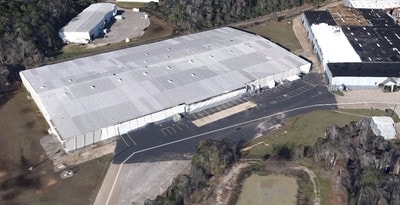
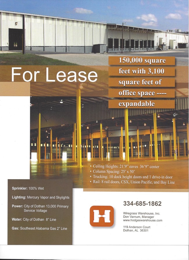
W Carroll St
09-07-26-4-001-013-000
BEG @ INT OF SE R/W OF RAILROAD & W LN OF SE1/4 OF SE1/4 OF SEC 26 T3N R26E TH NE ALG RR R/W 580' SE 259.34' S 133.79' S W
Warehouse
HOUSTON
B and X Area of moderate flood hazard, usually the area between the limits of the 100-year and 500-year floods.
Alabama
2025
9.43 AC
2025
Dothan/Enterprise
041100
Other Market Areas
150,056 SF
Dothan, AL
NEARBY LISTINGS FOR SALE OR LEASE
DEMOGRAPHICS near W Carroll St
1 mile
3 mile
5 mile
2025 Total Population
5,046
39,466
66,639
2030 Population
5,082
40,113
67,628
Pop Growth 2025-2030
+ 0.71%
+ 1.64%
+ 1.48%
Average Age
39
40
40
2025 Total Households
2,072
16,561
28,081
HH Growth 2025-2030
+ 0.77%
+ 1.67%
+ 1.51%
Median Household Inc
$41,144
$43,892
$54,790
Avg Household Size
2.40
2.30
2.30
2025 Avg HH Vehicles
2.00
2.00
2.00
Median Home Value
$110,751
$164,123
$184,478
Median Year Built
1964
1974
1980
Nearby Places
Map Layers
Map Styles
 Street
 Aerial
Layers
 Traffic
 Biking
Places
Listings with unknown addresses are not visible on the map
- Restaurants
- Banks
- Shops
- Fitness
- Groceries
PUBLIC TRANSPORTATION
AIRPORT
Dothan Regional
Drive
Walk
Distance
Dothan Regional
19 min
10.0 mi
SALE & LEASE HISTORY
LISTING DATE
SALE/LEASE

Oct 31, 2016
For Sale
Nearby Properties
Address
Land Use
TOTAL SIZE
Lot Size
Zoning
Address
Land Use
TOTAL SIZE
Lot Size
Zoning
1,938 SF
2 AC
Address
Land Use
TOTAL SIZE
Lot Size
Zoning
7,198 SF
Address
Land Use
TOTAL SIZE
Lot Size
Zoning
628 SF
22.30 AC
Address
Land Use
TOTAL SIZE
Lot Size
Zoning
39,500 SF
1.97 AC
Address
Land Use
TOTAL SIZE
Lot Size
Zoning
152,685 SF
16.80 AC
Address
Land Use
TOTAL SIZE
Lot Size
Zoning
88,725 SF
17 AC
Address
Land Use
TOTAL SIZE
Lot Size
Zoning
720 SF
12.39 AC
Address
Land Use
TOTAL SIZE
Lot Size
Zoning
900 SF
38 AC
Address
Land Use
TOTAL SIZE
Lot Size
Zoning
182 SF
0.53 AC
Address
Land Use
TOTAL SIZE
Lot Size
Zoning
828 SF
14.30 AC
Address
Land Use
TOTAL SIZE
Lot Size
Zoning
323 SF
60 AC
Address
Land Use
TOTAL SIZE
Lot Size
Zoning
3,213 SF
12.66 AC
Address
Land Use
TOTAL SIZE
Lot Size
Zoning
244,027 SF
Address
Land Use
TOTAL SIZE
Lot Size
Zoning
53,736 SF
9.20 AC
Address
Land Use
TOTAL SIZE
Lot Size
Zoning
460 SF
3.90 AC
Address
Land Use
TOTAL SIZE
Lot Size
Zoning
52,270 SF
3.84 AC
Address
Land Use
TOTAL SIZE
Lot Size
Zoning
160,000 SF
4.83 AC
Address
Land Use
TOTAL SIZE
Lot Size
Zoning
90,918 SF
0.88 AC
Address
Land Use
TOTAL SIZE
Lot Size
Zoning
257,000 SF
9.85 AC
Address
Land Use
TOTAL SIZE
Lot Size
Zoning
46,974 SF
0.55 AC
Address
Land Use
TOTAL SIZE
Lot Size
Zoning
1,700 SF
3.49 AC
Address
Land Use
TOTAL SIZE
Lot Size
Zoning
37,140 SF
0.43 AC
Address
Land Use
TOTAL SIZE
Lot Size
Zoning
25,300 SF
1.24 AC
Address
Land Use
TOTAL SIZE
Lot Size
Zoning
62,263 SF
20 AC
Address
Land Use
TOTAL SIZE
Lot Size
Zoning
19,239 SF
16 AC
Address
Land Use
TOTAL SIZE
Lot Size
Zoning
1,656 SF
1.57 AC
Address
Land Use
TOTAL SIZE
Lot Size
Zoning
72,200 SF
2.89 AC
Address
Land Use
TOTAL SIZE
Lot Size
Zoning
154,000 SF
5.68 AC
Address
Land Use
TOTAL SIZE
Lot Size
Zoning
24,352 SF
5.34 AC
Address
Land Use
TOTAL SIZE
Lot Size
Zoning
35,850 SF
30 AC
The World's #1 Commercial Real Estate Marketplace
Connect with us
© 2026 CoStar Group
The information above has been obtained from sources believed reliable. While we do not doubt its accuracy we have not verified it and make no guarantee, warranty or representation about it. It is your responsibility to independently confirm its accuracy and completeness. Any projections, opinions, assumptions, or estimates used are for example only and do not represent the current or future performance of the property. The value of this transaction to you depends on tax and other factors which should be evaluated by your tax, financial, and legal advisors. You and your advisors should conduct a careful, independent investigation of the property to determine to your satisfaction the suitability of the property for your needs.