Property Record
W Centerton Blvd W, Centerton, AR 72719

Property Detail
W Centerton Blvd W
Fayetteville-Springdale-Rogers, AR
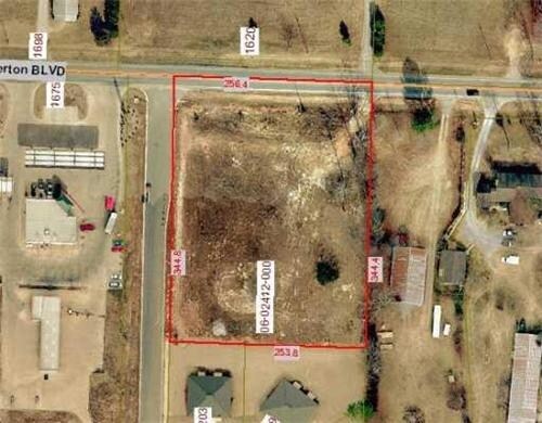
PART OF THE NW1/4 OF THE NW1/4 OF SECTION 5, TOWNSHIP 19 NORTH, RANGE 31 WEST, BENTON COUNTY, ARKANSAS, ALSO KNOWN AS LOT 38, GRAYSTONE SUBDIVISION, CENTERTON, MORE PARTICULARLY DESCRIBED AS FOLLOWS: BEGINNING AT A POINT 995.56 FEET S 87*3004 E AND 9
06-02412-000
BENTON
Commercialacreage
Arkansas
B and X Area of moderate flood hazard, usually the area between the limits of the 100-year and 500-year floods.
38
2025
2.01 AC
2025
Outlying Benton County
020904
Fayetteville/Springdale/Rogers
NEARBY LISTINGS FOR SALE OR LEASE
DEMOGRAPHICS near W Centerton Blvd W
1 mile
3 mile
5 mile
2025 Total Population
6,134
27,180
60,826
2030 Population
6,977
30,430
67,849
Pop Growth 2025-2030
+ 13.74%
+ 11.96%
+ 11.55%
Average Age
33
33
34
2025 Total Households
2,049
9,276
21,491
HH Growth 2025-2030
+ 14.06%
+ 12.31%
+ 11.84%
Median Household Inc
$103,834
$114,124
$118,824
Avg Household Size
3.00
2.90
2.80
2025 Avg HH Vehicles
2.00
2.00
2.00
Median Home Value
$430,517
$396,919
$404,844
Median Year Built
2010
2009
2010
Nearby Places
Map Layers
Map Styles
 Street
 Aerial
Layers
 Traffic
 Biking
Places
Listings with unknown addresses are not visible on the map
- Restaurants
- Banks
- Shops
- Fitness
- Groceries
PUBLIC TRANSPORTATION
AIRPORT
Northwest Arkansas Ntl
Drive
Walk
Distance
Northwest Arkansas Ntl
14 min
6.7 mi
Nearby Properties
Address
Land Use
TOTAL SIZE
Lot Size
Zoning
Address
Land Use
TOTAL SIZE
Lot Size
Zoning
254,163 SF
10.98 AC
Address
Land Use
TOTAL SIZE
Lot Size
Zoning
218,437 SF
17.90 AC
Address
Land Use
TOTAL SIZE
Lot Size
Zoning
199,773 SF
14.09 AC
Address
Land Use
TOTAL SIZE
Lot Size
Zoning
57,290 SF
5 AC
Address
Land Use
TOTAL SIZE
Lot Size
Zoning
61,320 SF
1.78 AC
Address
Land Use
TOTAL SIZE
Lot Size
Zoning
96,719 SF
9.12 AC
Address
Land Use
TOTAL SIZE
Lot Size
Zoning
81,020 SF
5.37 AC
Address
Land Use
TOTAL SIZE
Lot Size
Zoning
66,750 SF
5.54 AC
Address
Land Use
TOTAL SIZE
Lot Size
Zoning
49,880 SF
5.34 AC
Address
Land Use
TOTAL SIZE
Lot Size
Zoning
10,988 SF
1.11 AC
Address
Land Use
TOTAL SIZE
Lot Size
Zoning
17,576 SF
2.77 AC
Address
Land Use
TOTAL SIZE
Lot Size
Zoning
19,320 SF
4 AC
Address
Land Use
TOTAL SIZE
Lot Size
Zoning
7,346 SF
3.85 AC
Address
Land Use
TOTAL SIZE
Lot Size
Zoning
14,138 SF
2.15 AC
Address
Land Use
TOTAL SIZE
Lot Size
Zoning
20.58 AC
Address
Land Use
TOTAL SIZE
Lot Size
Zoning
27,600 SF
2.59 AC
Address
Land Use
TOTAL SIZE
Lot Size
Zoning
21,800 SF
7 AC
Address
Land Use
TOTAL SIZE
Lot Size
Zoning
10,612 SF
1.40 AC
Address
Land Use
TOTAL SIZE
Lot Size
Zoning
14,010 SF
1.67 AC
Address
Land Use
TOTAL SIZE
Lot Size
Zoning
6,398 SF
0.87 AC
Address
Land Use
TOTAL SIZE
Lot Size
Zoning
52,520 SF
4.72 AC
Address
Land Use
TOTAL SIZE
Lot Size
Zoning
10,057 SF
1.22 AC
Address
Land Use
TOTAL SIZE
Lot Size
Zoning
1,132 SF
0.89 AC
Address
Land Use
TOTAL SIZE
Lot Size
Zoning
Address
Land Use
TOTAL SIZE
Lot Size
Zoning
48,630 SF
6.53 AC
Address
Land Use
TOTAL SIZE
Lot Size
Zoning
9,750 SF
1.10 AC
Address
Land Use
TOTAL SIZE
Lot Size
Zoning
30,918 SF
2.54 AC
Address
Land Use
TOTAL SIZE
Lot Size
Zoning
4,273 SF
1.26 AC
Address
Land Use
TOTAL SIZE
Lot Size
Zoning
2,728 SF
1.47 AC
Address
Land Use
TOTAL SIZE
Lot Size
Zoning
40,930 SF
4 AC
The World's #1 Commercial Real Estate Marketplace
Connect with us
© 2026 CoStar Group
The information above has been obtained from sources believed reliable. While we do not doubt its accuracy we have not verified it and make no guarantee, warranty or representation about it. It is your responsibility to independently confirm its accuracy and completeness. Any projections, opinions, assumptions, or estimates used are for example only and do not represent the current or future performance of the property. The value of this transaction to you depends on tax and other factors which should be evaluated by your tax, financial, and legal advisors. You and your advisors should conduct a careful, independent investigation of the property to determine to your satisfaction the suitability of the property for your needs.