Property Record
W D Ave, Kalamazoo, MI 49009
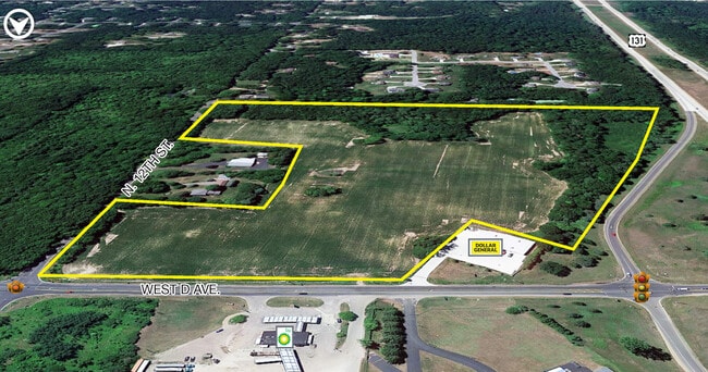

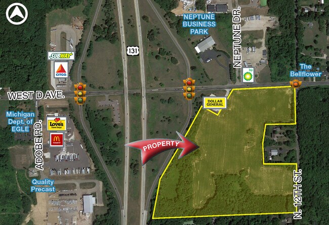
This Property Is For Sale
Property Detail
W D Ave
01-24-226-021
SEC 24-1-12 BEG NE COR TH S 1DEG17MIN56MIN W ALG E LI 450.23 FT TH N 88DEG05MIN36SEC W 355.89 FT TH S 10DEG15 MIN56SEC W
Agriculturalland
KALAMAZOO
C-2
Michigan
B and X Area of moderate flood hazard, usually the area between the limits of the 100-year and 500-year floods.
42.12 AC
2024
Western Kalamazoo County
2025
West Michigan
002911
Kalamazoo-Portage, MI
NEARBY LISTINGS FOR SALE OR LEASE
-
-
View all Kalamazoo listings for sale on LoopNet.com
DEMOGRAPHICS near W D Ave
1 mile
3 mile
5 mile
2025 Total Population
733
4,762
22,544
2030 Population
723
4,699
22,345
Pop Growth 2025-2030
(1.36%)
(1.32%)
(0.88%)
Average Age
43
43
42
2025 Total Households
282
1,864
8,960
HH Growth 2025-2030
(1.42%)
(1.50%)
(1.12%)
Median Household Inc
$85,000
$79,969
$76,497
Avg Household Size
2.60
2.50
2.40
2025 Avg HH Vehicles
2.00
2.00
2.00
Median Home Value
$297,825
$286,040
$252,143
Median Year Built
1978
1978
1977
Nearby Places
Map Layers
Map Styles
 Street
 Aerial
Layers
 Traffic
 Biking
Places
Listings with unknown addresses are not visible on the map
- Restaurants
- Banks
- Shops
- Fitness
- Groceries
PUBLIC TRANSPORTATION
AIRPORT
Kalamazoo/Battle Creek International
Drive
Walk
Distance
Kalamazoo/Battle Creek International
26 min
16.7 mi
Freight Ports
Port of Toledo
Drive
Walk
Distance
Port of Toledo
189 min
154.9 mi
Nearby Properties
Address
Land Use
TOTAL SIZE
Lot Size
Zoning
Address
Land Use
TOTAL SIZE
Lot Size
Zoning
12,360 SF
5.92 AC
C-2
Address
Land Use
TOTAL SIZE
Lot Size
Zoning
5,772 SF
25 AC
R-4 MOB
Address
Land Use
TOTAL SIZE
Lot Size
Zoning
20,158 SF
2.99 AC
C-2
Address
Land Use
TOTAL SIZE
Lot Size
Zoning
64,580 SF
15.70 AC
C-2
Address
Land Use
TOTAL SIZE
Lot Size
Zoning
15,814 SF
10.41 AC
CBD
Address
Land Use
TOTAL SIZE
Lot Size
Zoning
24,900 SF
Address
Land Use
TOTAL SIZE
Lot Size
Zoning
201 AC
AG
Address
Land Use
TOTAL SIZE
Lot Size
Zoning
16,000 SF
11.20 AC
C-2
Address
Land Use
TOTAL SIZE
Lot Size
Zoning
92,160 SF
37.48 AC
R1
Address
Land Use
TOTAL SIZE
Lot Size
Zoning
37,284 SF
3.22 AC
I-2
Address
Land Use
TOTAL SIZE
Lot Size
Zoning
5,011 SF
123.63 AC
RD
Address
Land Use
TOTAL SIZE
Lot Size
Zoning
8,769 SF
31.87 AC
C-2
Address
Land Use
TOTAL SIZE
Lot Size
Zoning
5,033 SF
7.73 AC
I-3
Address
Land Use
TOTAL SIZE
Lot Size
Zoning
354 SF
165.23 AC
R-2
Address
Land Use
TOTAL SIZE
Lot Size
Zoning
18,000 SF
5.09 AC
CBD
Address
Land Use
TOTAL SIZE
Lot Size
Zoning
5.33 AC
C-2
Address
Land Use
TOTAL SIZE
Lot Size
Zoning
3,200 SF
50.85 AC
R1
Address
Land Use
TOTAL SIZE
Lot Size
Zoning
26,220 SF
3.82 AC
C-2
Address
Land Use
TOTAL SIZE
Lot Size
Zoning
2,602 SF
39.68 AC
AG
Address
Land Use
TOTAL SIZE
Lot Size
Zoning
1,977 SF
68.23 AC
Address
Land Use
TOTAL SIZE
Lot Size
Zoning
8,700 SF
16.43 AC
C-2
Address
Land Use
TOTAL SIZE
Lot Size
Zoning
10 AC
I-3
Address
Land Use
TOTAL SIZE
Lot Size
Zoning
23,112 SF
9.84 AC
I-2
Address
Land Use
TOTAL SIZE
Lot Size
Zoning
14,454 SF
2.17 AC
I-2
Address
Land Use
TOTAL SIZE
Lot Size
Zoning
15,520 SF
24.59 AC
C-2
Address
Land Use
TOTAL SIZE
Lot Size
Zoning
9,350 SF
1.37 AC
C-2
Address
Land Use
TOTAL SIZE
Lot Size
Zoning
9,921 SF
2.14 AC
I-2
Address
Land Use
TOTAL SIZE
Lot Size
Zoning
21,612 SF
2.28 AC
I-2
Address
Land Use
TOTAL SIZE
Lot Size
Zoning
19,836 SF
3.55 AC
I1
Address
Land Use
TOTAL SIZE
Lot Size
Zoning
111.18 AC
R1
The World's #1 Commercial Real Estate Marketplace
Connect with us
© 2026 CoStar Group
The information above has been obtained from sources believed reliable. While we do not doubt its accuracy we have not verified it and make no guarantee, warranty or representation about it. It is your responsibility to independently confirm its accuracy and completeness. Any projections, opinions, assumptions, or estimates used are for example only and do not represent the current or future performance of the property. The value of this transaction to you depends on tax and other factors which should be evaluated by your tax, financial, and legal advisors. You and your advisors should conduct a careful, independent investigation of the property to determine to your satisfaction the suitability of the property for your needs.