Property Record
W E Baab Industrial Dr, Taylorsville, NC 28681


NEARBY LISTINGS FOR SALE OR LEASE
Property Detail
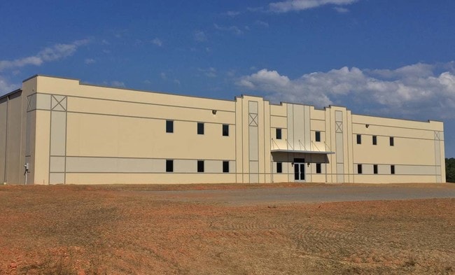
W E Baab Industrial Dr
Hickory-Lenoir-Morganton, NC
Boundary And Division Survey For Alexand
0067284
Alexander
Vacantlandnec
North Carolina
X
74.31 AC
3710377900J
Alexander County
50,000 SF
Charlotte
DEMOGRAPHICS near W E Baab Industrial Dr
1 Mile
3 Mile
5 Mile
2024 Total Population
748
6,194
14,824
2029 Population
762
6,299
15,146
Pop Growth 2024-2029
+ 1.87%
+ 1.70%
+ 2.17%
Average Age
41
42
42
2024 Total Households
310
2,440
5,683
HH Growth 2024-2029
+ 1.61%
+ 1.64%
+ 2.27%
Median Household Inc
$48,976
$47,797
$50,133
Avg Household Size
2.40
2.40
2.40
2024 Avg HH Vehicles
2.00
2.00
2.00
Median Home Value
$156,666
$157,887
$155,898
Median Year Built
1978
1979
1983
Nearby Places
Map Layers
Map Styles
 Street
 Aerial
- Restaurants
- Banks
- Shops
- Fitness
- Groceries
SALE & LEASE HISTORY
LISTING DATE
SALE/LEASE

Sep 25, 2016
For Lease
Sep 24, 2016
For Sale
Sep 14, 2017
For Lease
Nearby Properties
Address
Land Use
TOTAL SIZE
Lot Size
Zoning
Address
Land Use
TOTAL SIZE
Lot Size
Zoning
329,140 SF
43.93 AC
LI
Address
Land Use
TOTAL SIZE
Lot Size
Zoning
56,459 SF
71 AC
RA20
Address
Land Use
TOTAL SIZE
Lot Size
Zoning
35,560 SF
1.17 AC
B2
Address
Land Use
TOTAL SIZE
Lot Size
Zoning
63,000 SF
4.63 AC
LI
Address
Land Use
TOTAL SIZE
Lot Size
Zoning
50,000 SF
8.10 AC
LI
Address
Land Use
TOTAL SIZE
Lot Size
Zoning
31,494 SF
11.30 AC
RA20
Address
Land Use
TOTAL SIZE
Lot Size
Zoning
70,000 SF
25.61 AC
LI
Address
Land Use
TOTAL SIZE
Lot Size
Zoning
156,552 SF
16.50 AC
LI
Address
Land Use
TOTAL SIZE
Lot Size
Zoning
154,362 SF
21.29 AC
M2
Address
Land Use
TOTAL SIZE
Lot Size
Zoning
152,280 SF
17.84 AC
HI
Address
Land Use
TOTAL SIZE
Lot Size
Zoning
11,446 SF
1.39 AC
HC
Address
Land Use
TOTAL SIZE
Lot Size
Zoning
15,725 SF
2.51 AC
R2
Address
Land Use
TOTAL SIZE
Lot Size
Zoning
50,000 SF
10.40 AC
LI
Address
Land Use
TOTAL SIZE
Lot Size
Zoning
19,548 SF
5.55 AC
RA20
Address
Land Use
TOTAL SIZE
Lot Size
Zoning
76,932 SF
31.75 AC
LI
Address
Land Use
TOTAL SIZE
Lot Size
Zoning
116,794 SF
10 AC
LI
Address
Land Use
TOTAL SIZE
Lot Size
Zoning
203,945 SF
23.70 AC
LI
Address
Land Use
TOTAL SIZE
Lot Size
Zoning
183,600 SF
18.77 AC
LI
Address
Land Use
TOTAL SIZE
Lot Size
Zoning
97,442 SF
13.39 AC
RA20
Address
Land Use
TOTAL SIZE
Lot Size
Zoning
6,518 SF
7.51 AC
Address
Land Use
TOTAL SIZE
Lot Size
Zoning
61,500 SF
15.29 AC
LI
Address
Land Use
TOTAL SIZE
Lot Size
Zoning
3,976 SF
22.53 AC
HC
Address
Land Use
TOTAL SIZE
Lot Size
Zoning
14,973 SF
8.50 AC
M2
Address
Land Use
TOTAL SIZE
Lot Size
Zoning
4,811 SF
3.51 AC
HC
Address
Land Use
TOTAL SIZE
Lot Size
Zoning
9,200 SF
3.47 AC
HC
Address
Land Use
TOTAL SIZE
Lot Size
Zoning
12,790 SF
8.17 AC
RA20
Address
Land Use
TOTAL SIZE
Lot Size
Zoning
37,200 SF
11 AC
LI
Address
Land Use
TOTAL SIZE
Lot Size
Zoning
21,177 SF
4.60 AC
B2
Address
Land Use
TOTAL SIZE
Lot Size
Zoning
12,000 SF
6.69 AC
LI
Address
Land Use
TOTAL SIZE
Lot Size
Zoning
81,160 SF
19.34 AC
LI
The World's #1 Commercial Real Estate Marketplace
Connect with us
© 2026 CoStar Group
The information above has been obtained from sources believed reliable. While we do not doubt its accuracy we have not verified it and make no guarantee, warranty or representation about it. It is your responsibility to independently confirm its accuracy and completeness. Any projections, opinions, assumptions, or estimates used are for example only and do not represent the current or future performance of the property. The value of this transaction to you depends on tax and other factors which should be evaluated by your tax, financial, and legal advisors. You and your advisors should conduct a careful, independent investigation of the property to determine to your satisfaction the suitability of the property for your needs.