Property Record
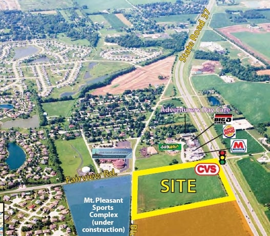
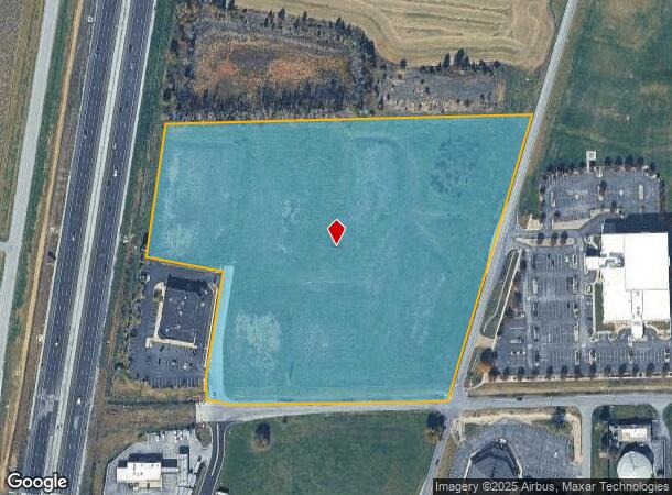
W Fairview Rd, Greenwood, IN 46142
NEARBY LISTINGS FOR SALE OR LEASE
Property Detail
W Fairview Rd
Indianapolis-Carmel-Anderson, IN
Market Place Re-Sub
41-03-28-034-002.000-038
MARKET PLACE PT BLOCK A FINAL PLAT THE
Commercialacreage
Johnson
X
Indiana
18109C0180E
14.06 AC
2024
Greenwood
2025
Indianapolis
610606
DEMOGRAPHICS near W Fairview Rd
1 Mile
3 Mile
5 Mile
2024 Total Population
3,591
37,260
111,586
2029 Population
3,798
38,406
114,053
Pop Growth 2024-2029
+ 5.76%
+ 3.08%
+ 2.21%
Average Age
41
40
39
2024 Total Households
1,287
13,486
41,548
HH Growth 2024-2029
+ 5.91%
+ 3.08%
+ 2.23%
Median Household Inc
$117,011
$102,125
$82,137
Avg Household Size
2.80
2.70
2.60
2024 Avg HH Vehicles
2.00
2.00
2.00
Median Home Value
$260,818
$243,107
$236,519
Median Year Built
1993
1992
1990
Nearby Places
- Restaurants
- Banks
- Shops
- Fitness
- Groceries
PUBLIC TRANSPORTATION
AIRPORT
Indianapolis International
DRIVE
WALK
Distance
Indianapolis International
29 min
18.0 mi
Freight Ports
Port of Toledo
DRIVE
WALK
Distance
Port of Toledo
286 min
240.0 mi
SALE & LEASE HISTORY
LISTING DATE
SALE/LEASE

Sep 24, 2016
For Sale
Nearby Properties
Address
Land Use
TOTAL SIZE
Lot Size
Zoning
Address
Land Use
TOTAL SIZE
Lot Size
Zoning
5,279 SF
18.07 AC
ZO01
Address
Land Use
TOTAL SIZE
Lot Size
Zoning
5,779 SF
15.77 AC
Address
Land Use
TOTAL SIZE
Lot Size
Zoning
65,551 SF
12.84 AC
ZO01
Address
Land Use
TOTAL SIZE
Lot Size
Zoning
152,664 SF
14.82 AC
Address
Land Use
TOTAL SIZE
Lot Size
Zoning
11,326 SF
7.88 AC
Address
Land Use
TOTAL SIZE
Lot Size
Zoning
217,468 SF
28.06 AC
Address
Land Use
TOTAL SIZE
Lot Size
Zoning
193,178 SF
14.48 AC
Address
Land Use
TOTAL SIZE
Lot Size
Zoning
46,171 SF
4.55 AC
Address
Land Use
TOTAL SIZE
Lot Size
Zoning
4,308 SF
8.36 AC
ZO01
Address
Land Use
TOTAL SIZE
Lot Size
Zoning
78,421 SF
9.62 AC
Address
Land Use
TOTAL SIZE
Lot Size
Zoning
98,316 SF
10.58 AC
Address
Land Use
TOTAL SIZE
Lot Size
Zoning
93,870 SF
18.53 AC
B2
Address
Land Use
TOTAL SIZE
Lot Size
Zoning
50,723 SF
38.38 AC
ZO01
Address
Land Use
TOTAL SIZE
Lot Size
Zoning
51,840 SF
4.31 AC
Address
Land Use
TOTAL SIZE
Lot Size
Zoning
32,792 SF
1 AC
Address
Land Use
TOTAL SIZE
Lot Size
Zoning
1,131 SF
26.34 AC
ZO01
Address
Land Use
TOTAL SIZE
Lot Size
Zoning
42,057 SF
3.70 AC
Address
Land Use
TOTAL SIZE
Lot Size
Zoning
23,026 SF
3.96 AC
Address
Land Use
TOTAL SIZE
Lot Size
Zoning
22,590 SF
3.08 AC
R4
Address
Land Use
TOTAL SIZE
Lot Size
Zoning
41,445 SF
3.66 AC
ZO01
Address
Land Use
TOTAL SIZE
Lot Size
Zoning
71,272 SF
5.89 AC
ZO01
Address
Land Use
TOTAL SIZE
Lot Size
Zoning
12,788 SF
2.03 AC
B2
Address
Land Use
TOTAL SIZE
Lot Size
Zoning
3,200 SF
0.97 AC
Address
Land Use
TOTAL SIZE
Lot Size
Zoning
10,226 SF
1.34 AC
Address
Land Use
TOTAL SIZE
Lot Size
Zoning
3,094 SF
59.72 AC
R5
Address
Land Use
TOTAL SIZE
Lot Size
Zoning
2,464 SF
17.27 AC
RR
Address
Land Use
TOTAL SIZE
Lot Size
Zoning
31,496 SF
4.57 AC
Address
Land Use
TOTAL SIZE
Lot Size
Zoning
17,800 SF
1.07 AC
Address
Land Use
TOTAL SIZE
Lot Size
Zoning
16,321 SF
9.57 AC
Address
Land Use
TOTAL SIZE
Lot Size
Zoning
39,600 SF
4.27 AC
The World's #1 Commercial Real Estate Marketplace
Connect with us
© 2025 CoStar Group
The information above has been obtained from sources believed reliable. While we do not doubt its accuracy we have not verified it and make no guarantee, warranty or representation about it. It is your responsibility to independently confirm its accuracy and completeness. Any projections, opinions, assumptions, or estimates used are for example only and do not represent the current or future performance of the property. The value of this transaction to you depends on tax and other factors which should be evaluated by your tax, financial, and legal advisors. You and your advisors should conduct a careful, independent investigation of the property to determine to your satisfaction the suitability of the property for your needs.