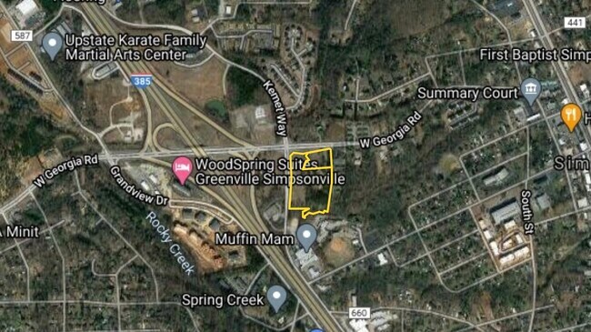
Property Record
W Georgia Rd, , SC

Save to a Folder
{{folder.Name}}
{{folder.ListingIds.length}} Properties
{{folder.ListingIds.length}} Property
Create a New Folder
Property Detail
W Georgia Rd
Greenville-Anderson-Greer, SC
MAP 0306.00; 1
0306.00-02-005.02
GREENVILLE
Residentialacreage
South Carolina
BG
005.00
B and X Area of moderate flood hazard, usually the area between the limits of the 100-year and 500-year floods.
6.88 AC
2025
Mauldin/Fountain
2025
Greenville/Spartanburg
003005
NEARBY LISTINGS FOR SALE OR LEASE
DEMOGRAPHICS near W Georgia Rd
1 mile
3 mile
5 mile
2025 Total Population
7,834
53,766
121,832
2030 Population
8,463
58,072
131,766
Pop Growth 2025-2030
+ 8.03%
+ 8.01%
+ 8.15%
Average Age
40
40
40
2025 Total Households
3,441
20,640
46,779
HH Growth 2025-2030
+ 8.28%
+ 8.26%
+ 8.38%
Median Household Inc
$74,723
$94,225
$91,944
Avg Household Size
2.30
2.60
2.60
2025 Avg HH Vehicles
2.00
2.00
2.00
Median Home Value
$267,759
$324,435
$318,435
Median Year Built
1986
1999
1999
Nearby Places
Map Layers
Map Styles
 Street
 Aerial
Layers
 Traffic
 Biking
Places
Listings with unknown addresses are not visible on the map
- Restaurants
- Banks
- Shops
- Fitness
- Groceries
PUBLIC TRANSPORTATION
AIRPORT
Greenville Spartanburg International
Drive
Walk
Distance
Greenville Spartanburg International
22 min
14.8 mi
Freight Ports
North Charleston Terminal
Drive
Walk
Distance
North Charleston Terminal
213 min
191.0 mi
SALE & LEASE HISTORY
LISTING DATE
SALE/LEASE

Sep 24, 2016
For Sale
Sep 09, 2020
For Sale
May 30, 2017
For Sale
May 15, 2017
For Sale
Nearby Properties
Address
Land Use
TOTAL SIZE
Lot Size
Zoning
Address
Land Use
TOTAL SIZE
Lot Size
Zoning
23.23 AC
Address
Land Use
TOTAL SIZE
Lot Size
Zoning
103.69 AC
RRROW
Address
Land Use
TOTAL SIZE
Lot Size
Zoning
16.32 AC
ROI
Address
Land Use
TOTAL SIZE
Lot Size
Zoning
17.02 AC
BG
Address
Land Use
TOTAL SIZE
Lot Size
Zoning
12.31 AC
Address
Land Use
TOTAL SIZE
Lot Size
Zoning
17.59 AC
Address
Land Use
TOTAL SIZE
Lot Size
Zoning
195.23 AC
RRROW
Address
Land Use
TOTAL SIZE
Lot Size
Zoning
24.77 AC
ROI
Address
Land Use
TOTAL SIZE
Lot Size
Zoning
11.91 AC
RM20
Address
Land Use
TOTAL SIZE
Lot Size
Zoning
10.04 AC
BG
Address
Land Use
TOTAL SIZE
Lot Size
Zoning
29.21 AC
I1
Address
Land Use
TOTAL SIZE
Lot Size
Zoning
26.30 AC
ROI
Address
Land Use
TOTAL SIZE
Lot Size
Zoning
31.37 AC
I1
Address
Land Use
TOTAL SIZE
Lot Size
Zoning
4.59 AC
BI
Address
Land Use
TOTAL SIZE
Lot Size
Zoning
10.78 AC
I1
Address
Land Use
TOTAL SIZE
Lot Size
Zoning
Address
Land Use
TOTAL SIZE
Lot Size
Zoning
12.11 AC
BG
Address
Land Use
TOTAL SIZE
Lot Size
Zoning
9.89 AC
C2
Address
Land Use
TOTAL SIZE
Lot Size
Zoning
5.30 AC
BI
Address
Land Use
TOTAL SIZE
Lot Size
Zoning
9.46 AC
I1
Address
Land Use
TOTAL SIZE
Lot Size
Zoning
50.76 AC
PDC
Address
Land Use
TOTAL SIZE
Lot Size
Zoning
76.20 AC
R20
Address
Land Use
TOTAL SIZE
Lot Size
Zoning
1,176 SF
126.24 AC
RS
Address
Land Use
TOTAL SIZE
Lot Size
Zoning
12.43 AC
RS
Address
Land Use
TOTAL SIZE
Lot Size
Zoning
10.50 AC
RRROW
Address
Land Use
TOTAL SIZE
Lot Size
Zoning
12.87 AC
RLO
Address
Land Use
TOTAL SIZE
Lot Size
Zoning
51.30 AC
RS
Address
Land Use
TOTAL SIZE
Lot Size
Zoning
Address
Land Use
TOTAL SIZE
Lot Size
Zoning
89.72 AC
RLO
Address
Land Use
TOTAL SIZE
Lot Size
Zoning
7.10 AC
BG
The World's #1 Commercial Real Estate Marketplace
Connect with us
© 2026 CoStar Group
The information above has been obtained from sources believed reliable. While we do not doubt its accuracy we have not verified it and make no guarantee, warranty or representation about it. It is your responsibility to independently confirm its accuracy and completeness. Any projections, opinions, assumptions, or estimates used are for example only and do not represent the current or future performance of the property. The value of this transaction to you depends on tax and other factors which should be evaluated by your tax, financial, and legal advisors. You and your advisors should conduct a careful, independent investigation of the property to determine to your satisfaction the suitability of the property for your needs.