Property Record
W Highway 105, Monument, CO 80132

NEARBY LISTINGS FOR SALE OR LEASE
-
-
View all Monument listings for sale on LoopNet.com
Property Detail
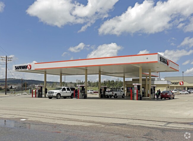
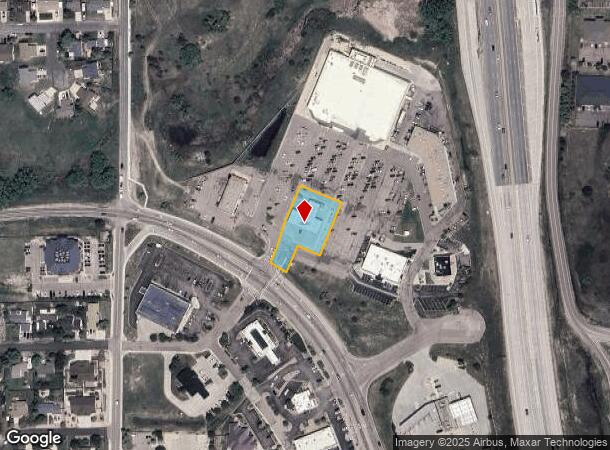
W Highway 105
Colorado Springs, CO
Monument Market Centre Fil No 1 - Replat
71142-01-018
LOT 2 MONUMENT MARKET CENTRE FIL NO 1 REPLAT A
Commercialbuilding
El Paso
X
Colorado
08041C0276G
2
2024
0.64 AC
2025
Northwest
007401
Colorado Springs
625 SF
DEMOGRAPHICS near W Highway 105
1 Mile
3 Mile
5 Mile
2024 Total Population
3,926
23,144
39,886
2029 Population
4,134
24,155
41,692
Pop Growth 2024-2029
+ 5.30%
+ 4.37%
+ 4.53%
Average Age
42
42
42
2024 Total Households
1,435
8,215
14,047
HH Growth 2024-2029
+ 5.37%
+ 4.53%
+ 4.70%
Median Household Inc
$112,665
$129,529
$139,474
Avg Household Size
2.70
2.80
2.80
2024 Avg HH Vehicles
2.00
3.00
3.00
Median Home Value
$603,997
$626,755
$621,983
Median Year Built
1991
1995
1997
Nearby Places
Map Layers
Map Styles
 Street
 Aerial
- Restaurants
- Banks
- Shops
- Fitness
- Groceries
PUBLIC TRANSPORTATION
AIRPORT
City of Colorado Springs Municipal
DRIVE
WALK
Distance
City of Colorado Springs Municipal
40 min
26.5 mi
Nearby Properties
Address
Land Use
TOTAL SIZE
Lot Size
Zoning
Address
Land Use
TOTAL SIZE
Lot Size
Zoning
136,906 SF
25.22 AC
PRD-4
Address
Land Use
TOTAL SIZE
Lot Size
Zoning
57,619 SF
3.26 AC
SFD-2
Address
Land Use
TOTAL SIZE
Lot Size
Zoning
22,970 SF
5.45 AC
PUD
Address
Land Use
TOTAL SIZE
Lot Size
Zoning
49,258 SF
3.68 AC
PUD
Address
Land Use
TOTAL SIZE
Lot Size
Zoning
53,026 SF
17.20 AC
RR-5
Address
Land Use
TOTAL SIZE
Lot Size
Zoning
23,378 SF
3.34 AC
PUD
Address
Land Use
TOTAL SIZE
Lot Size
Zoning
600 SF
40 AC
A-5
Address
Land Use
TOTAL SIZE
Lot Size
Zoning
222,850 SF
20.55 AC
PUD
Address
Land Use
TOTAL SIZE
Lot Size
Zoning
21,695 SF
1.17 AC
BP
Address
Land Use
TOTAL SIZE
Lot Size
Zoning
38,142 SF
7.28 AC
A-5
Address
Land Use
TOTAL SIZE
Lot Size
Zoning
25,600 SF
10.11 AC
CC
Address
Land Use
TOTAL SIZE
Lot Size
Zoning
150,335 SF
28 AC
LI
Address
Land Use
TOTAL SIZE
Lot Size
Zoning
13.14 AC
PUD
Address
Land Use
TOTAL SIZE
Lot Size
Zoning
16,608 SF
1.14 AC
P
Address
Land Use
TOTAL SIZE
Lot Size
Zoning
12,167 SF
1.40 AC
DB
Address
Land Use
TOTAL SIZE
Lot Size
Zoning
272.98 AC
RR-5
Address
Land Use
TOTAL SIZE
Lot Size
Zoning
31,037 SF
9.80 AC
PUD
Address
Land Use
TOTAL SIZE
Lot Size
Zoning
14,684 SF
5 AC
RS-20000
Address
Land Use
TOTAL SIZE
Lot Size
Zoning
16,235 SF
6.08 AC
RR-5
Address
Land Use
TOTAL SIZE
Lot Size
Zoning
9.62 AC
PID
Address
Land Use
TOTAL SIZE
Lot Size
Zoning
16,230 SF
2.81 AC
Address
Land Use
TOTAL SIZE
Lot Size
Zoning
198,725 SF
10.39 AC
PUD
Address
Land Use
TOTAL SIZE
Lot Size
Zoning
53,337 SF
12 AC
PCD
Address
Land Use
TOTAL SIZE
Lot Size
Zoning
11,794 SF
17.98 AC
RR-5
Address
Land Use
TOTAL SIZE
Lot Size
Zoning
9,631 SF
15.85 AC
PUD
Address
Land Use
TOTAL SIZE
Lot Size
Zoning
1.68 AC
A-5
Address
Land Use
TOTAL SIZE
Lot Size
Zoning
103,554 SF
12.94 AC
PUD
Address
Land Use
TOTAL SIZE
Lot Size
Zoning
12.30 AC
CC
Address
Land Use
TOTAL SIZE
Lot Size
Zoning
625 SF
23.13 AC
SFD-2
Address
Land Use
TOTAL SIZE
Lot Size
Zoning
87,656 SF
4.30 AC
I-2
The World's #1 Commercial Real Estate Marketplace
Connect with us
© 2026 CoStar Group
The information above has been obtained from sources believed reliable. While we do not doubt its accuracy we have not verified it and make no guarantee, warranty or representation about it. It is your responsibility to independently confirm its accuracy and completeness. Any projections, opinions, assumptions, or estimates used are for example only and do not represent the current or future performance of the property. The value of this transaction to you depends on tax and other factors which should be evaluated by your tax, financial, and legal advisors. You and your advisors should conduct a careful, independent investigation of the property to determine to your satisfaction the suitability of the property for your needs.