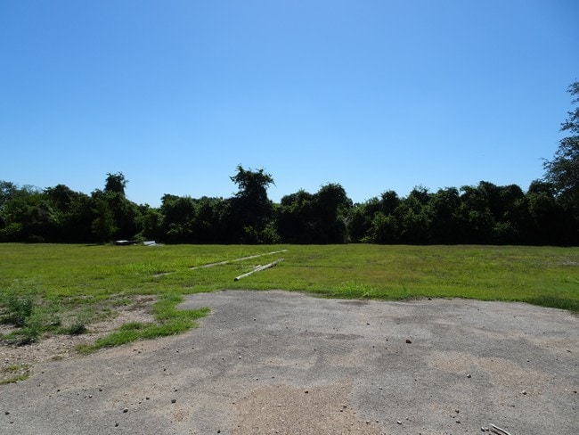
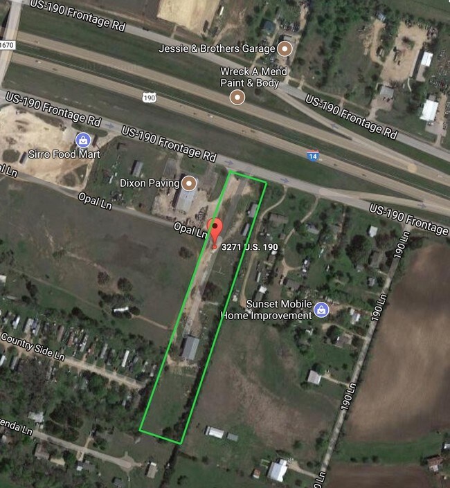
Property Record
W Highway 190, Belton, TX 76513

Property Detail
W Highway 190
103763
A0512BC J LEWIS, 6-5, CENTROPLEX MOBILE HOMES, ACRES 5.083
Commercialnec
BELL
B and X Area of moderate flood hazard, usually the area between the limits of the 100-year and 500-year floods.
Texas
2025
10.17 AC
2025
Outlying Bell County
021602
Killeen/Temple/Fort Hood
5,184 SF
Killeen-Temple, TX
NEARBY LISTINGS FOR SALE OR LEASE
DEMOGRAPHICS near W Highway 190
1 mile
3 mile
5 mile
2025 Total Population
1,665
21,729
38,722
2030 Population
1,756
23,252
41,344
Pop Growth 2025-2030
+ 5.47%
+ 7.01%
+ 6.77%
Average Age
37
35
37
2025 Total Households
635
7,024
13,526
HH Growth 2025-2030
+ 5.35%
+ 7.56%
+ 7.02%
Median Household Inc
$80,906
$69,005
$83,182
Avg Household Size
2.60
2.70
2.60
2025 Avg HH Vehicles
2.00
2.00
2.00
Median Home Value
$295,521
$277,632
$327,071
Median Year Built
2010
2005
2003
Nearby Places
Map Layers
Map Styles
 Street
 Aerial
Transit
 Traffic
 Biking
Places
Listings with unknown addresses are not visible on the map
- Restaurants
- Banks
- Shops
- Fitness
- Groceries
PUBLIC TRANSPORTATION
AIRPORT
Killeen Municipal
Drive
Walk
Distance
Killeen Municipal
19 min
12.6 mi
Robert Gray AAF
Drive
Walk
Distance
Robert Gray AAF
38 min
26.5 mi
SALE & LEASE HISTORY
LISTING DATE
SALE/LEASE

Oct 26, 2023
For Lease
Aug 10, 2017
For Sale
Nearby Properties
Address
Land Use
TOTAL SIZE
Lot Size
Zoning
Address
Land Use
TOTAL SIZE
Lot Size
Zoning
523,244 SF
74.89 AC
Address
Land Use
TOTAL SIZE
Lot Size
Zoning
39.79 AC
Address
Land Use
TOTAL SIZE
Lot Size
Zoning
148,268 SF
30.02 AC
Address
Land Use
TOTAL SIZE
Lot Size
Zoning
42,313 SF
1.38 AC
Address
Land Use
TOTAL SIZE
Lot Size
Zoning
85,530 SF
101.80 AC
Address
Land Use
TOTAL SIZE
Lot Size
Zoning
174,116 SF
75.93 AC
Address
Land Use
TOTAL SIZE
Lot Size
Zoning
205,244 SF
12.51 AC
Address
Land Use
TOTAL SIZE
Lot Size
Zoning
87,881 SF
15.69 AC
Address
Land Use
TOTAL SIZE
Lot Size
Zoning
126,176 SF
6.05 AC
Address
Land Use
TOTAL SIZE
Lot Size
Zoning
118,382 SF
7.50 AC
Address
Land Use
TOTAL SIZE
Lot Size
Zoning
82,750 SF
4.52 AC
Address
Land Use
TOTAL SIZE
Lot Size
Zoning
79,179 SF
15.38 AC
Address
Land Use
TOTAL SIZE
Lot Size
Zoning
133,640 SF
8.37 AC
Address
Land Use
TOTAL SIZE
Lot Size
Zoning
39,880 SF
19.78 AC
Address
Land Use
TOTAL SIZE
Lot Size
Zoning
110,069 SF
11.12 AC
Address
Land Use
TOTAL SIZE
Lot Size
Zoning
85,446 SF
25.88 AC
Address
Land Use
TOTAL SIZE
Lot Size
Zoning
60,678 SF
14.84 AC
Address
Land Use
TOTAL SIZE
Lot Size
Zoning
120,610 SF
3 AC
Address
Land Use
TOTAL SIZE
Lot Size
Zoning
40,089 SF
1.97 AC
Address
Land Use
TOTAL SIZE
Lot Size
Zoning
107,487 SF
0.28 AC
Address
Land Use
TOTAL SIZE
Lot Size
Zoning
161,200 SF
47.14 AC
Address
Land Use
TOTAL SIZE
Lot Size
Zoning
78,128 SF
2.01 AC
Address
Land Use
TOTAL SIZE
Lot Size
Zoning
370.52 AC
Address
Land Use
TOTAL SIZE
Lot Size
Zoning
61,184 SF
6.94 AC
Address
Land Use
TOTAL SIZE
Lot Size
Zoning
59,292 SF
9.05 AC
Address
Land Use
TOTAL SIZE
Lot Size
Zoning
0.41 AC
Address
Land Use
TOTAL SIZE
Lot Size
Zoning
7,143 SF
21.62 AC
Address
Land Use
TOTAL SIZE
Lot Size
Zoning
38,045 SF
71.04 AC
Address
Land Use
TOTAL SIZE
Lot Size
Zoning
38,474 SF
3.74 AC
Address
Land Use
TOTAL SIZE
Lot Size
Zoning
20,260 SF
5.38 AC
The World's #1 Commercial Real Estate Marketplace
Connect with us
© 2026 CoStar Group
The information above has been obtained from sources believed reliable. While we do not doubt its accuracy we have not verified it and make no guarantee, warranty or representation about it. It is your responsibility to independently confirm its accuracy and completeness. Any projections, opinions, assumptions, or estimates used are for example only and do not represent the current or future performance of the property. The value of this transaction to you depends on tax and other factors which should be evaluated by your tax, financial, and legal advisors. You and your advisors should conduct a careful, independent investigation of the property to determine to your satisfaction the suitability of the property for your needs.