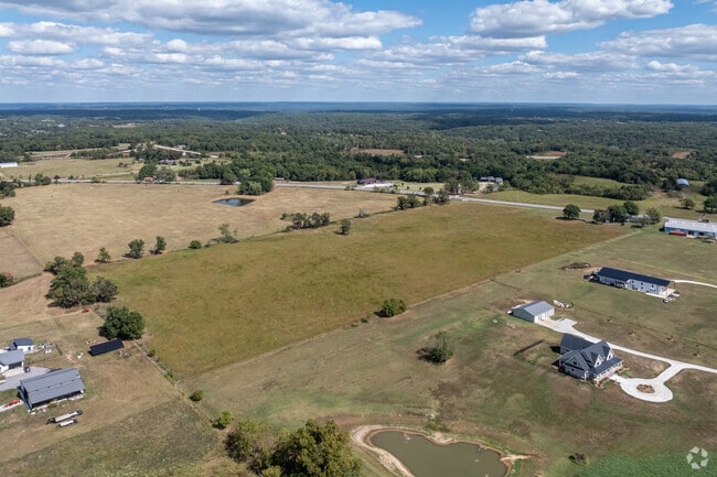
Property Record
W Highway 72, Gravette, AR 72736

Property Detail
W Highway 72
Fayetteville-Springdale-Rogers, AR
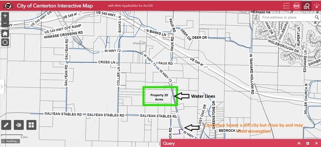
SURVEYS: 11/01/2017 L2017057290 (2 PGS) A PART OF THE SOUTHEAST QUARTER (SE 1/4) OF THE NORTHWEST QUARTER (NW 1/4) AND PART OF THE SOUTHWEST QUARTER (SW 1/4) OF THE NORTHEAST QUARTER (NE 1/4) OF SECTION SEVENTEEN (17), TOWNSHIP TWENTY (20) NORTH, RAN
18-09673-000
BENTON
Residentialacreage
Arkansas
B and X Area of moderate flood hazard, usually the area between the limits of the 100-year and 500-year floods.
20.24 AC
2025
Outlying Benton County
2025
Fayetteville/Springdale/Rogers
020905
NEARBY LISTINGS FOR SALE OR LEASE
DEMOGRAPHICS near W Highway 72
1 mile
3 mile
5 mile
2025 Total Population
560
10,628
54,188
2030 Population
632
11,925
60,156
Pop Growth 2025-2030
+ 12.86%
+ 12.20%
+ 11.01%
Average Age
36
37
39
2025 Total Households
201
3,668
20,103
HH Growth 2025-2030
+ 12.94%
+ 12.49%
+ 11.29%
Median Household Inc
$92,279
$111,868
$107,765
Avg Household Size
2.80
2.90
2.70
2025 Avg HH Vehicles
2.00
2.00
2.00
Median Home Value
$397,999
$459,658
$392,124
Median Year Built
2009
2008
2003
Nearby Places
Map Layers
Map Styles
 Street
 Aerial
Layers
 Traffic
 Biking
Places
Listings with unknown addresses are not visible on the map
- Restaurants
- Banks
- Shops
- Fitness
- Groceries
PUBLIC TRANSPORTATION
AIRPORT
Northwest Arkansas Ntl
Drive
Walk
Distance
Northwest Arkansas Ntl
26 min
12.0 mi
Freight Ports
Tulsa Port of Inola
Drive
Walk
Distance
Tulsa Port of Inola
117 min
93.9 mi
SALE & LEASE HISTORY
LISTING DATE
SALE/LEASE

Sep 17, 2024
For Sale
Nearby Properties
Address
Land Use
TOTAL SIZE
Lot Size
Zoning
Address
Land Use
TOTAL SIZE
Lot Size
Zoning
79,908 SF
11 AC
Address
Land Use
TOTAL SIZE
Lot Size
Zoning
38,595 SF
6.43 AC
Address
Land Use
TOTAL SIZE
Lot Size
Zoning
86,153 SF
5 AC
Address
Land Use
TOTAL SIZE
Lot Size
Zoning
54,611 SF
4.72 AC
Address
Land Use
TOTAL SIZE
Lot Size
Zoning
28,000 SF
4.73 AC
Address
Land Use
TOTAL SIZE
Lot Size
Zoning
60,030 SF
5.26 AC
Address
Land Use
TOTAL SIZE
Lot Size
Zoning
40,050 SF
3.23 AC
Address
Land Use
TOTAL SIZE
Lot Size
Zoning
19,976 SF
14.19 AC
Address
Land Use
TOTAL SIZE
Lot Size
Zoning
6,768 SF
1.13 AC
Address
Land Use
TOTAL SIZE
Lot Size
Zoning
32,472 SF
4.40 AC
Address
Land Use
TOTAL SIZE
Lot Size
Zoning
21,090 SF
2.32 AC
Address
Land Use
TOTAL SIZE
Lot Size
Zoning
6,250 SF
5.42 AC
Address
Land Use
TOTAL SIZE
Lot Size
Zoning
6,183 SF
2.13 AC
Address
Land Use
TOTAL SIZE
Lot Size
Zoning
12,600 SF
22.65 AC
Address
Land Use
TOTAL SIZE
Lot Size
Zoning
18,180 SF
2.99 AC
Address
Land Use
TOTAL SIZE
Lot Size
Zoning
4,590 SF
2 AC
Address
Land Use
TOTAL SIZE
Lot Size
Zoning
29,104 SF
9.78 AC
Address
Land Use
TOTAL SIZE
Lot Size
Zoning
4,949 SF
2.79 AC
Address
Land Use
TOTAL SIZE
Lot Size
Zoning
31,216 SF
6.03 AC
Address
Land Use
TOTAL SIZE
Lot Size
Zoning
24,587 SF
3.13 AC
Address
Land Use
TOTAL SIZE
Lot Size
Zoning
16,395 SF
17.95 AC
Address
Land Use
TOTAL SIZE
Lot Size
Zoning
4,421 SF
1.18 AC
Address
Land Use
TOTAL SIZE
Lot Size
Zoning
24 SF
8.15 AC
Address
Land Use
TOTAL SIZE
Lot Size
Zoning
7,959 SF
17.42 AC
Address
Land Use
TOTAL SIZE
Lot Size
Zoning
2,689 SF
1.78 AC
Address
Land Use
TOTAL SIZE
Lot Size
Zoning
4,793 SF
0.35 AC
Address
Land Use
TOTAL SIZE
Lot Size
Zoning
3,372 SF
4.56 AC
Address
Land Use
TOTAL SIZE
Lot Size
Zoning
4,653 SF
0.31 AC
Address
Land Use
TOTAL SIZE
Lot Size
Zoning
1,704 SF
0.63 AC
Address
Land Use
TOTAL SIZE
Lot Size
Zoning
9,450 SF
3.81 AC
The World's #1 Commercial Real Estate Marketplace
Connect with us
© 2026 CoStar Group
The information above has been obtained from sources believed reliable. While we do not doubt its accuracy we have not verified it and make no guarantee, warranty or representation about it. It is your responsibility to independently confirm its accuracy and completeness. Any projections, opinions, assumptions, or estimates used are for example only and do not represent the current or future performance of the property. The value of this transaction to you depends on tax and other factors which should be evaluated by your tax, financial, and legal advisors. You and your advisors should conduct a careful, independent investigation of the property to determine to your satisfaction the suitability of the property for your needs.