Property Record
W Highway 84, Mcgregor, TX 76657

Property Detail
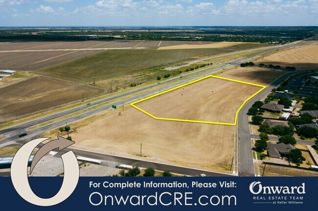
W Highway 84
Waco, TX
SUNWEST VILLAGE LOT 1 BLOCK 2 ACRES 2.7
36-336201-000201-0
MCLENNAN
Commercialacreage
Texas
C2
1
B and X Area of moderate flood hazard, usually the area between the limits of the 100-year and 500-year floods.
2.70 AC
2024
Waco
2025
Other Market Areas
003901
NEARBY LISTINGS FOR SALE OR LEASE
DEMOGRAPHICS near W Highway 84
1 mile
3 mile
5 mile
2025 Total Population
2,678
7,358
16,437
2030 Population
2,806
7,630
16,985
Pop Growth 2025-2030
+ 4.78%
+ 3.70%
+ 3.33%
Average Age
39
41
41
2025 Total Households
898
2,590
5,894
HH Growth 2025-2030
+ 4.79%
+ 3.59%
+ 3.27%
Median Household Inc
$147,560
$134,881
$120,503
Avg Household Size
3.00
2.80
2.80
2025 Avg HH Vehicles
2.00
2.00
2.00
Median Home Value
$482,608
$486,376
$434,942
Median Year Built
2003
2001
1996
Nearby Places
Map Layers
Map Styles
 Street
 Aerial
Layers
 Traffic
 Biking
Places
Listings with unknown addresses are not visible on the map
- Restaurants
- Banks
- Shops
- Fitness
- Groceries
PUBLIC TRANSPORTATION
COMMUTER RAIL
Drive
Walk
Distance
9 min
6.6 mi
AIRPORT
Waco Regional
Drive
Walk
Distance
Waco Regional
32 min
17.8 mi
SALE & LEASE HISTORY
LISTING DATE
SALE/LEASE

Jul 02, 2020
For Sale
Nearby Properties
Address
Land Use
TOTAL SIZE
Lot Size
Zoning
Address
Land Use
TOTAL SIZE
Lot Size
Zoning
227,078 SF
27.79 AC
R1B
Address
Land Use
TOTAL SIZE
Lot Size
Zoning
61,437 SF
7.03 AC
R1
Address
Land Use
TOTAL SIZE
Lot Size
Zoning
54,979 SF
15.59 AC
R1
Address
Land Use
TOTAL SIZE
Lot Size
Zoning
72,339 SF
4.90 AC
Address
Land Use
TOTAL SIZE
Lot Size
Zoning
150,976 SF
20 AC
C
Address
Land Use
TOTAL SIZE
Lot Size
Zoning
144,622 SF
8.53 AC
Address
Land Use
TOTAL SIZE
Lot Size
Zoning
99,900 SF
26.57 AC
R
Address
Land Use
TOTAL SIZE
Lot Size
Zoning
8,745 SF
3 AC
Address
Land Use
TOTAL SIZE
Lot Size
Zoning
111,811 SF
776.67 AC
R1
Address
Land Use
TOTAL SIZE
Lot Size
Zoning
56,420 SF
20 AC
Address
Land Use
TOTAL SIZE
Lot Size
Zoning
17,511 SF
3.54 AC
R
Address
Land Use
TOTAL SIZE
Lot Size
Zoning
12,720 SF
7 AC
R
Address
Land Use
TOTAL SIZE
Lot Size
Zoning
10,300 SF
3.35 AC
C1
Address
Land Use
TOTAL SIZE
Lot Size
Zoning
7,078 SF
24 AC
Address
Land Use
TOTAL SIZE
Lot Size
Zoning
8,570 SF
21.17 AC
R1
Address
Land Use
TOTAL SIZE
Lot Size
Zoning
21,218 SF
2.43 AC
Address
Land Use
TOTAL SIZE
Lot Size
Zoning
4,820 SF
180.37 AC
PUD
Address
Land Use
TOTAL SIZE
Lot Size
Zoning
4,875 SF
11.74 AC
R
Address
Land Use
TOTAL SIZE
Lot Size
Zoning
26,200 SF
2.10 AC
Address
Land Use
TOTAL SIZE
Lot Size
Zoning
6.13 AC
Address
Land Use
TOTAL SIZE
Lot Size
Zoning
4,138 SF
13.14 AC
R1
Address
Land Use
TOTAL SIZE
Lot Size
Zoning
4,878 SF
6.52 AC
Address
Land Use
TOTAL SIZE
Lot Size
Zoning
5,648 SF
3.50 AC
C
Address
Land Use
TOTAL SIZE
Lot Size
Zoning
13.10 AC
Address
Land Use
TOTAL SIZE
Lot Size
Zoning
4,890 SF
11.40 AC
R1
Address
Land Use
TOTAL SIZE
Lot Size
Zoning
5,966 SF
43.50 AC
R1
Address
Land Use
TOTAL SIZE
Lot Size
Zoning
4,819 SF
0.51 AC
Address
Land Use
TOTAL SIZE
Lot Size
Zoning
6,422 SF
8.48 AC
R1
Address
Land Use
TOTAL SIZE
Lot Size
Zoning
3,567 SF
43.96 AC
Address
Land Use
TOTAL SIZE
Lot Size
Zoning
5,048 SF
61.04 AC
R
The World's #1 Commercial Real Estate Marketplace
Connect with us
© 2026 CoStar Group
The information above has been obtained from sources believed reliable. While we do not doubt its accuracy we have not verified it and make no guarantee, warranty or representation about it. It is your responsibility to independently confirm its accuracy and completeness. Any projections, opinions, assumptions, or estimates used are for example only and do not represent the current or future performance of the property. The value of this transaction to you depends on tax and other factors which should be evaluated by your tax, financial, and legal advisors. You and your advisors should conduct a careful, independent investigation of the property to determine to your satisfaction the suitability of the property for your needs.