Property Record
W Highway 84 Rd, Mcgregor, TX 76657
NEARBY LISTINGS FOR SALE OR LEASE
Property Detail
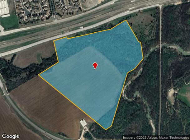
W Highway 84 Rd
Waco, TX
Roberts H
36-075100-001205-0
ROBERTS H (A-751) 48.37 AC, CLEMMONS L C (A-239) 8.556 AC, DAVIS B F (A-287) 5.32 AC TOTAL 62.246
Privatepreserveopenspacevacantlandforestlandconservation
Mclennan
AE
Texas
48309C0510C
62.24 AC
2024
Waco & Killeen
2025
Other Market Areas
003901
DEMOGRAPHICS near W Highway 84 Rd
1 Mile
3 Mile
5 Mile
2024 Total Population
1,616
9,552
41,050
2029 Population
1,669
9,885
43,298
Pop Growth 2024-2029
+ 3.28%
+ 3.49%
+ 5.48%
Average Age
41
41
41
2024 Total Households
585
3,396
15,166
HH Growth 2024-2029
+ 3.42%
+ 3.59%
+ 5.57%
Median Household Inc
$157,401
$152,389
$94,675
Avg Household Size
2.80
2.80
2.60
2024 Avg HH Vehicles
2.00
2.00
2.00
Median Home Value
$440,104
$409,533
$292,199
Median Year Built
2001
1997
1991
Nearby Places
Map Layers
Map Styles
 Street
 Aerial
- Restaurants
- Banks
- Shops
- Fitness
- Groceries
PUBLIC TRANSPORTATION
COMMUTER RAIL
Mcgregor Amtrak (Texas Eagle - Amtrak)
DRIVE
WALK
Distance
Mcgregor Amtrak (Texas Eagle - Amtrak)
13 min
9.5 mi
AIRPORT
Waco Regional
DRIVE
WALK
Distance
Waco Regional
29 min
16.0 mi
Freight Ports
Port of Houston
DRIVE
WALK
Distance
Port of Houston
224 min
196.4 mi
Nearby Properties
Address
Land Use
TOTAL SIZE
Lot Size
Zoning
Address
Land Use
TOTAL SIZE
Lot Size
Zoning
227,078 SF
27.79 AC
R1B
Address
Land Use
TOTAL SIZE
Lot Size
Zoning
61,437 SF
7.03 AC
R1
Address
Land Use
TOTAL SIZE
Lot Size
Zoning
54,979 SF
15.59 AC
R1
Address
Land Use
TOTAL SIZE
Lot Size
Zoning
80,437 SF
30.43 AC
C
Address
Land Use
TOTAL SIZE
Lot Size
Zoning
72,339 SF
4.90 AC
Address
Land Use
TOTAL SIZE
Lot Size
Zoning
17 AC
R
Address
Land Use
TOTAL SIZE
Lot Size
Zoning
65,920 SF
15 AC
R1
Address
Land Use
TOTAL SIZE
Lot Size
Zoning
144,622 SF
8.53 AC
Address
Land Use
TOTAL SIZE
Lot Size
Zoning
30,932 SF
2.54 AC
Address
Land Use
TOTAL SIZE
Lot Size
Zoning
8,745 SF
3 AC
Address
Land Use
TOTAL SIZE
Lot Size
Zoning
111,811 SF
776.67 AC
R1
Address
Land Use
TOTAL SIZE
Lot Size
Zoning
34,944 SF
5.68 AC
R
Address
Land Use
TOTAL SIZE
Lot Size
Zoning
56,420 SF
20 AC
Address
Land Use
TOTAL SIZE
Lot Size
Zoning
41,104 SF
2.01 AC
Address
Land Use
TOTAL SIZE
Lot Size
Zoning
21,680 SF
7.39 AC
Address
Land Use
TOTAL SIZE
Lot Size
Zoning
26,648 SF
3.36 AC
Address
Land Use
TOTAL SIZE
Lot Size
Zoning
17,511 SF
3.54 AC
R
Address
Land Use
TOTAL SIZE
Lot Size
Zoning
6,948 SF
1.15 AC
Address
Land Use
TOTAL SIZE
Lot Size
Zoning
19,971 SF
2.69 AC
C
Address
Land Use
TOTAL SIZE
Lot Size
Zoning
10,300 SF
3.35 AC
C1
Address
Land Use
TOTAL SIZE
Lot Size
Zoning
7,078 SF
24 AC
Address
Land Use
TOTAL SIZE
Lot Size
Zoning
8,570 SF
21.17 AC
R1
Address
Land Use
TOTAL SIZE
Lot Size
Zoning
5.09 AC
R1
Address
Land Use
TOTAL SIZE
Lot Size
Zoning
8,338 SF
1.01 AC
R
Address
Land Use
TOTAL SIZE
Lot Size
Zoning
21,218 SF
2.43 AC
Address
Land Use
TOTAL SIZE
Lot Size
Zoning
6,716 SF
1 AC
Address
Land Use
TOTAL SIZE
Lot Size
Zoning
4,820 SF
180.37 AC
PUD
Address
Land Use
TOTAL SIZE
Lot Size
Zoning
26,200 SF
2.10 AC
Address
Land Use
TOTAL SIZE
Lot Size
Zoning
6.13 AC
Address
Land Use
TOTAL SIZE
Lot Size
Zoning
5.54 AC
R
The World's #1 Commercial Real Estate Marketplace
Connect with us
© 2026 CoStar Group
The information above has been obtained from sources believed reliable. While we do not doubt its accuracy we have not verified it and make no guarantee, warranty or representation about it. It is your responsibility to independently confirm its accuracy and completeness. Any projections, opinions, assumptions, or estimates used are for example only and do not represent the current or future performance of the property. The value of this transaction to you depends on tax and other factors which should be evaluated by your tax, financial, and legal advisors. You and your advisors should conduct a careful, independent investigation of the property to determine to your satisfaction the suitability of the property for your needs.