Property Record
W Highway Ww, Columbia, MO 65201
Save to a Folder
{{folder.Name}}
{{folder.ListingIds.length}} Properties
{{folder.ListingIds.length}} Property
Create a New Folder
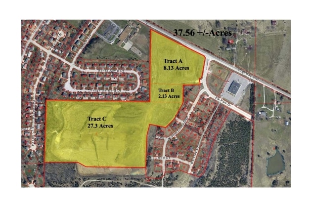
Property Detail
W Highway Ww
Columbia, MO
NPT NE 1/4 (SPT SUR 3225-114)
17-510-00-00-001-00-01
BOONE
Agriculturalland
Missouri
B and X Area of moderate flood hazard, usually the area between the limits of the 100-year and 500-year floods.
4
2025
2.13 AC
2025
Columbia/Jefferson City
001004
Other Market Areas
NEARBY LISTINGS FOR SALE OR LEASE
DEMOGRAPHICS near W Highway Ww
1 mile
3 mile
5 mile
2025 Total Population
2,439
44,088
98,693
2030 Population
2,615
45,905
102,544
Pop Growth 2025-2030
+ 7.22%
+ 4.12%
+ 3.90%
Average Age
38
34
35
2025 Total Households
1,040
17,995
40,667
HH Growth 2025-2030
+ 7.31%
+ 4.38%
+ 4.19%
Median Household Inc
$83,750
$52,589
$56,830
Avg Household Size
2.30
2.10
2.10
2025 Avg HH Vehicles
2.00
2.00
2.00
Median Home Value
$306,818
$221,708
$227,948
Median Year Built
2004
1992
1990
Nearby Places
Map Layers
Map Styles
 Street
 Aerial
Layers
 Traffic
 Biking
Places
Listings with unknown addresses are not visible on the map
- Restaurants
- Banks
- Shops
- Fitness
- Groceries
PUBLIC TRANSPORTATION
AIRPORT
Columbia Regional
Drive
Walk
Distance
Columbia Regional
18 min
12.9 mi
Freight Ports
Tulsa Port of Inola
Drive
Walk
Distance
Tulsa Port of Inola
379 min
335.6 mi
Nearby Properties
Address
Land Use
TOTAL SIZE
Lot Size
Zoning
Address
Land Use
TOTAL SIZE
Lot Size
Zoning
171,157 SF
5.60 AC
O1
Address
Land Use
TOTAL SIZE
Lot Size
Zoning
149,686 SF
15.26 AC
MC
Address
Land Use
TOTAL SIZE
Lot Size
Zoning
6,390 SF
28.23 AC
Address
Land Use
TOTAL SIZE
Lot Size
Zoning
40,016 SF
2.13 AC
O1
Address
Land Use
TOTAL SIZE
Lot Size
Zoning
10,459 SF
39.22 AC
RMH
Address
Land Use
TOTAL SIZE
Lot Size
Zoning
50,304 SF
8.78 AC
C1
Address
Land Use
TOTAL SIZE
Lot Size
Zoning
11,760 SF
22.98 AC
Address
Land Use
TOTAL SIZE
Lot Size
Zoning
89,638 SF
6.42 AC
C3
Address
Land Use
TOTAL SIZE
Lot Size
Zoning
52,568 SF
9.50 AC
Address
Land Use
TOTAL SIZE
Lot Size
Zoning
57,520 SF
56.57 AC
Address
Land Use
TOTAL SIZE
Lot Size
Zoning
12,098 SF
45.85 AC
Address
Land Use
TOTAL SIZE
Lot Size
Zoning
38,500 SF
3.10 AC
O1
Address
Land Use
TOTAL SIZE
Lot Size
Zoning
125,487 SF
3.36 AC
Address
Land Use
TOTAL SIZE
Lot Size
Zoning
33,732 SF
3.34 AC
O1
Address
Land Use
TOTAL SIZE
Lot Size
Zoning
3,420 SF
18.60 AC
R3
Address
Land Use
TOTAL SIZE
Lot Size
Zoning
8,678 SF
23.15 AC
R3
Address
Land Use
TOTAL SIZE
Lot Size
Zoning
264,960 SF
40.01 AC
R1
Address
Land Use
TOTAL SIZE
Lot Size
Zoning
148,500 SF
22.62 AC
R3
Address
Land Use
TOTAL SIZE
Lot Size
Zoning
68,408 SF
4.38 AC
O1
Address
Land Use
TOTAL SIZE
Lot Size
Zoning
184,413 SF
17.63 AC
CP
Address
Land Use
TOTAL SIZE
Lot Size
Zoning
119,520 SF
12.56 AC
Address
Land Use
TOTAL SIZE
Lot Size
Zoning
70,783 SF
5.07 AC
O1
Address
Land Use
TOTAL SIZE
Lot Size
Zoning
125,907 SF
22.59 AC
C3
Address
Land Use
TOTAL SIZE
Lot Size
Zoning
26,544 SF
1.24 AC
R1
Address
Land Use
TOTAL SIZE
Lot Size
Zoning
68,117 SF
9.13 AC
O1
Address
Land Use
TOTAL SIZE
Lot Size
Zoning
44,364 SF
7.32 AC
CP
Address
Land Use
TOTAL SIZE
Lot Size
Zoning
119,988 SF
8.87 AC
Address
Land Use
TOTAL SIZE
Lot Size
Zoning
32,686 SF
3.20 AC
O1
Address
Land Use
TOTAL SIZE
Lot Size
Zoning
13,024 SF
11.90 AC
R3
Address
Land Use
TOTAL SIZE
Lot Size
Zoning
176,300 SF
5.22 AC
The World's #1 Commercial Real Estate Marketplace
Connect with us
© 2026 CoStar Group
The information above has been obtained from sources believed reliable. While we do not doubt its accuracy we have not verified it and make no guarantee, warranty or representation about it. It is your responsibility to independently confirm its accuracy and completeness. Any projections, opinions, assumptions, or estimates used are for example only and do not represent the current or future performance of the property. The value of this transaction to you depends on tax and other factors which should be evaluated by your tax, financial, and legal advisors. You and your advisors should conduct a careful, independent investigation of the property to determine to your satisfaction the suitability of the property for your needs.