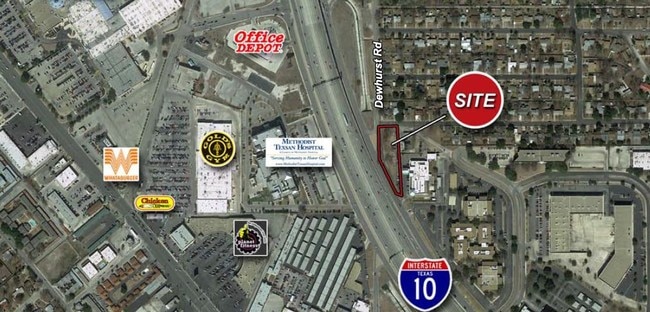
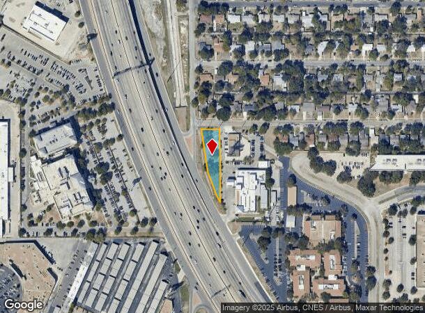
Property Record
W Ih 10, San Antonio, TX 78213
NEARBY LISTINGS FOR SALE OR LEASE
Property Detail
W Ih 10
14987-000-1000
NCB 14987 P-100 ABS 20 (TRACT 2) 2017-NEW ACCT CREATED PER APP A. FISHER REQUEST PER DEED 17682/974. LR/GIS/4-13-16.
Vacantlandnec
Bexar
AE
Texas
48029C0381H
0.47 AC
2024
Northwest
2025
San Antonio
191101
San Antonio-New Braunfels, TX
DEMOGRAPHICS near W Ih 10
1 Mile
3 Mile
5 Mile
2024 Total Population
16,520
146,568
391,373
2029 Population
17,632
155,437
416,070
Pop Growth 2024-2029
+ 6.73%
+ 6.05%
+ 6.31%
Average Age
39
38
38
2024 Total Households
7,129
59,657
158,651
HH Growth 2024-2029
+ 7.10%
+ 6.35%
+ 6.65%
Median Household Inc
$34,971
$43,507
$46,989
Avg Household Size
2.30
2.40
2.40
2024 Avg HH Vehicles
1.00
2.00
2.00
Median Home Value
$162,726
$175,518
$183,502
Median Year Built
1967
1968
1974
Nearby Places
Map Layers
Map Styles
 Street
 Aerial
- Restaurants
- Banks
- Shops
- Fitness
- Groceries
PUBLIC TRANSPORTATION
COMMUTER RAIL
San Antonio Amtrak Station (Sunset Limited - Amtrak, Texas Eagle - Amtrak)
DRIVE
WALK
Distance
San Antonio Amtrak Station (Sunset Limited - Amtrak, Texas Eagle - Amtrak)
13 min
8.2 mi
AIRPORT
San Antonio International
DRIVE
WALK
Distance
San Antonio International
9 min
6.0 mi
Freight Ports
Calhoun Port
DRIVE
WALK
Distance
Calhoun Port
190 min
155.6 mi
Nearby Properties
Address
Land Use
TOTAL SIZE
Lot Size
Zoning
Address
Land Use
TOTAL SIZE
Lot Size
Zoning
1,414,945 SF
16.77 AC
Address
Land Use
TOTAL SIZE
Lot Size
Zoning
609,267 SF
30.47 AC
Address
Land Use
TOTAL SIZE
Lot Size
Zoning
429,561 SF
25.70 AC
Address
Land Use
TOTAL SIZE
Lot Size
Zoning
97.47 AC
Address
Land Use
TOTAL SIZE
Lot Size
Zoning
278,352 SF
10 AC
Address
Land Use
TOTAL SIZE
Lot Size
Zoning
482,412 SF
22.97 AC
Address
Land Use
TOTAL SIZE
Lot Size
Zoning
227,744 SF
3.99 AC
Address
Land Use
TOTAL SIZE
Lot Size
Zoning
506,058 SF
25.23 AC
Address
Land Use
TOTAL SIZE
Lot Size
Zoning
495,484 SF
5.81 AC
Address
Land Use
TOTAL SIZE
Lot Size
Zoning
61.64 AC
Address
Land Use
TOTAL SIZE
Lot Size
Zoning
259,934 SF
9.81 AC
Address
Land Use
TOTAL SIZE
Lot Size
Zoning
211,045 SF
8.08 AC
Address
Land Use
TOTAL SIZE
Lot Size
Zoning
221,778 SF
16.31 AC
Address
Land Use
TOTAL SIZE
Lot Size
Zoning
137,036 SF
4.73 AC
Address
Land Use
TOTAL SIZE
Lot Size
Zoning
356,368 SF
18.58 AC
Address
Land Use
TOTAL SIZE
Lot Size
Zoning
122,292 SF
12.83 AC
Address
Land Use
TOTAL SIZE
Lot Size
Zoning
293,420 SF
9.24 AC
Address
Land Use
TOTAL SIZE
Lot Size
Zoning
256,678 SF
4.42 AC
Address
Land Use
TOTAL SIZE
Lot Size
Zoning
86,576 SF
7.84 AC
Address
Land Use
TOTAL SIZE
Lot Size
Zoning
138,674 SF
11.14 AC
Address
Land Use
TOTAL SIZE
Lot Size
Zoning
302,836 SF
15.96 AC
Address
Land Use
TOTAL SIZE
Lot Size
Zoning
191,827 SF
7.01 AC
Address
Land Use
TOTAL SIZE
Lot Size
Zoning
207,445 SF
9.55 AC
Address
Land Use
TOTAL SIZE
Lot Size
Zoning
64,712 SF
3.05 AC
Address
Land Use
TOTAL SIZE
Lot Size
Zoning
252,361 SF
14.35 AC
Address
Land Use
TOTAL SIZE
Lot Size
Zoning
Address
Land Use
TOTAL SIZE
Lot Size
Zoning
307,052 SF
9.91 AC
Address
Land Use
TOTAL SIZE
Lot Size
Zoning
97,800 SF
0.85 AC
Address
Land Use
TOTAL SIZE
Lot Size
Zoning
279,112 SF
10.62 AC
Address
Land Use
TOTAL SIZE
Lot Size
Zoning
171,986 SF
6.86 AC
The World's #1 Commercial Real Estate Marketplace
Connect with us
© 2025 CoStar Group
The information above has been obtained from sources believed reliable. While we do not doubt its accuracy we have not verified it and make no guarantee, warranty or representation about it. It is your responsibility to independently confirm its accuracy and completeness. Any projections, opinions, assumptions, or estimates used are for example only and do not represent the current or future performance of the property. The value of this transaction to you depends on tax and other factors which should be evaluated by your tax, financial, and legal advisors. You and your advisors should conduct a careful, independent investigation of the property to determine to your satisfaction the suitability of the property for your needs.