Property Record
W Lower Buckeye Rd, Buckeye, AZ 85326


Save to a Folder
{{folder.Name}}
{{folder.ListingIds.length}} Properties
{{folder.ListingIds.length}} Property
Create a New Folder
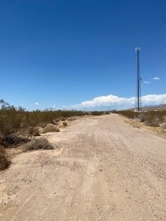
Property Detail
W Lower Buckeye Rd
504-27-012W
SE4 SE4 SW4 SEC 14 EX S 40F & W 33F RD & EX N 125F SE4 SE4 SW4
Commercialacreage
MARICOPA
C-G
Arizona
C and X Area of minimal flood hazard, usually depicted on FIRMs as above the 500-year flood level.
7.13 AC
2025
Southwest Outlying
2025
Phoenix
050617
Phoenix-Mesa-Chandler, AZ
NEARBY LISTINGS FOR SALE OR LEASE
DEMOGRAPHICS near W Lower Buckeye Rd
1 mile
3 mile
5 mile
2025 Total Population
46
7,828
44,116
2030 Population
48
8,379
47,143
Pop Growth 2025-2030
+ 4.35%
+ 7.04%
+ 6.86%
Average Age
35
34
34
2025 Total Households
12
2,253
13,111
HH Growth 2025-2030
0.00%
+ 7.28%
+ 6.97%
Median Household Inc
$156,250
$89,251
$87,886
Avg Household Size
3.10
3.40
3.30
2025 Avg HH Vehicles
2.00
2.00
2.00
Median Home Value
$379,999
$389,833
$363,798
Median Year Built
2003
2007
2008
Nearby Places
Map Layers
Map Styles
 Street
 Aerial
Layers
 Traffic
 Biking
Places
Listings with unknown addresses are not visible on the map
- Restaurants
- Banks
- Shops
- Fitness
- Groceries
SALE & LEASE HISTORY
LISTING DATE
SALE/LEASE

Sep 14, 2023
For Sale
Nearby Properties
Address
Land Use
TOTAL SIZE
Lot Size
Zoning
Address
Land Use
TOTAL SIZE
Lot Size
Zoning
862,622 SF
75.39 AC
GC
Address
Land Use
TOTAL SIZE
Lot Size
Zoning
326,103 SF
21.54 AC
Address
Land Use
TOTAL SIZE
Lot Size
Zoning
93,337 SF
15.37 AC
PC
Address
Land Use
TOTAL SIZE
Lot Size
Zoning
858,000 SF
69.08 AC
GC
Address
Land Use
TOTAL SIZE
Lot Size
Zoning
72,254 SF
13.66 AC
PAD
Address
Land Use
TOTAL SIZE
Lot Size
Zoning
127,192 SF
307.39 AC
C-G
Address
Land Use
TOTAL SIZE
Lot Size
Zoning
3.10 AC
Address
Land Use
TOTAL SIZE
Lot Size
Zoning
38,620 SF
20.87 AC
C-G
Address
Land Use
TOTAL SIZE
Lot Size
Zoning
30,320 SF
13.81 AC
PAD
Address
Land Use
TOTAL SIZE
Lot Size
Zoning
106,305 SF
9.11 AC
C-G
Address
Land Use
TOTAL SIZE
Lot Size
Zoning
58,500 SF
10.58 AC
C2
Address
Land Use
TOTAL SIZE
Lot Size
Zoning
23,758 SF
4.36 AC
C-G
Address
Land Use
TOTAL SIZE
Lot Size
Zoning
24,119 SF
5.13 AC
CC
Address
Land Use
TOTAL SIZE
Lot Size
Zoning
48.63 AC
C-G
Address
Land Use
TOTAL SIZE
Lot Size
Zoning
307.39 AC
C-G
Address
Land Use
TOTAL SIZE
Lot Size
Zoning
6,812 SF
6.72 AC
C-G
Address
Land Use
TOTAL SIZE
Lot Size
Zoning
43,912 SF
151.98 AC
RU43
Address
Land Use
TOTAL SIZE
Lot Size
Zoning
473.17 AC
R-43
Address
Land Use
TOTAL SIZE
Lot Size
Zoning
7,118 SF
3.55 AC
C-C
Address
Land Use
TOTAL SIZE
Lot Size
Zoning
1.04 AC
Address
Land Use
TOTAL SIZE
Lot Size
Zoning
24,030 SF
1.64 AC
C-G
Address
Land Use
TOTAL SIZE
Lot Size
Zoning
17,640 SF
2.93 AC
C-G
Address
Land Use
TOTAL SIZE
Lot Size
Zoning
81.59 AC
R-43
Address
Land Use
TOTAL SIZE
Lot Size
Zoning
0.57 AC
Address
Land Use
TOTAL SIZE
Lot Size
Zoning
4,840 SF
0.97 AC
Address
Land Use
TOTAL SIZE
Lot Size
Zoning
9,476 SF
18.45 AC
IND-2
Address
Land Use
TOTAL SIZE
Lot Size
Zoning
2,644 SF
21.35 AC
C-G
Address
Land Use
TOTAL SIZE
Lot Size
Zoning
5,324 SF
0.80 AC
CC
The World's #1 Commercial Real Estate Marketplace
Connect with us
© 2026 CoStar Group
The information above has been obtained from sources believed reliable. While we do not doubt its accuracy we have not verified it and make no guarantee, warranty or representation about it. It is your responsibility to independently confirm its accuracy and completeness. Any projections, opinions, assumptions, or estimates used are for example only and do not represent the current or future performance of the property. The value of this transaction to you depends on tax and other factors which should be evaluated by your tax, financial, and legal advisors. You and your advisors should conduct a careful, independent investigation of the property to determine to your satisfaction the suitability of the property for your needs.