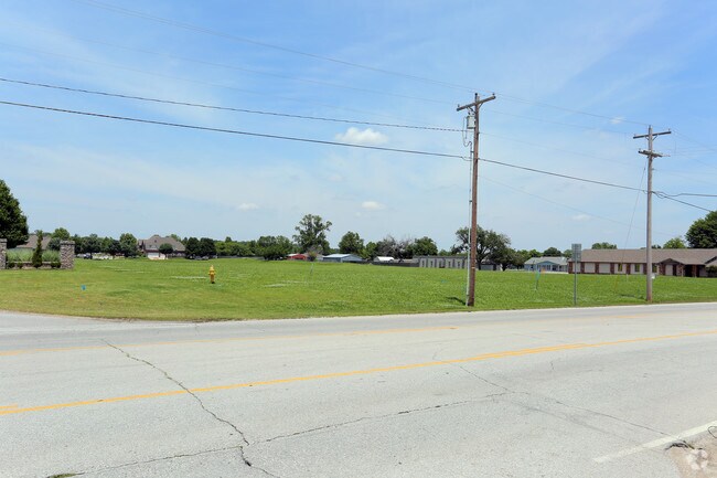
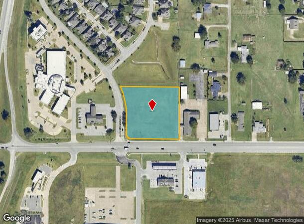
Property Record
W Main St S, Jenks, OK 74037
NEARBY LISTINGS FOR SALE OR LEASE
Property Detail
W Main St S
Tulsa
Staplehurst
Tulsa, OK
LT 1 BLK 7
60962-82-23-22800
Tulsa
Commercialacreage
Oklahoma
2025
1
2025
2.62 AC
006710
South
DEMOGRAPHICS near W Main St S
1 Mile
3 Mile
5 Mile
2024 Total Population
1,859
30,899
108,252
2029 Population
1,894
31,890
112,057
Pop Growth 2024-2029
+ 1.88%
+ 3.21%
+ 3.51%
Average Age
37
37
38
2024 Total Households
681
11,801
43,302
HH Growth 2024-2029
+ 2.06%
+ 3.13%
+ 3.50%
Median Household Inc
$88,505
$71,914
$61,730
Avg Household Size
2.70
2.60
2.40
2024 Avg HH Vehicles
2.00
2.00
2.00
Median Home Value
$261,589
$261,692
$234,712
Median Year Built
2002
2000
1984
Nearby Places
Map Layers
Map Styles
 Street
 Aerial
- Restaurants
- Banks
- Shops
- Fitness
- Groceries
PUBLIC TRANSPORTATION
AIRPORT
Tulsa International
DRIVE
WALK
Distance
Tulsa International
26 min
18.7 mi
Freight Ports
Tulsa Port Of Catoosa
DRIVE
WALK
Distance
Tulsa Port Of Catoosa
35 min
26.2 mi
Nearby Properties
Address
Land Use
TOTAL SIZE
Lot Size
Zoning
Address
Land Use
TOTAL SIZE
Lot Size
Zoning
1,584,609 SF
84.41 AC
AG
Address
Land Use
TOTAL SIZE
Lot Size
Zoning
49,344 SF
5.34 AC
CG
Address
Land Use
TOTAL SIZE
Lot Size
Zoning
325 SF
44.06 AC
RM2
Address
Land Use
TOTAL SIZE
Lot Size
Zoning
415.28 AC
IL
Address
Land Use
TOTAL SIZE
Lot Size
Zoning
58,907 SF
5 AC
CG
Address
Land Use
TOTAL SIZE
Lot Size
Zoning
301,267 SF
25.06 AC
IL
Address
Land Use
TOTAL SIZE
Lot Size
Zoning
358,394 SF
38.86 AC
Address
Land Use
TOTAL SIZE
Lot Size
Zoning
58,977 SF
15.85 AC
CS
Address
Land Use
TOTAL SIZE
Lot Size
Zoning
15.98 AC
OMH
Address
Land Use
TOTAL SIZE
Lot Size
Zoning
56,984 SF
5.54 AC
RS3
Address
Land Use
TOTAL SIZE
Lot Size
Zoning
30,418 SF
7.86 AC
CM
Address
Land Use
TOTAL SIZE
Lot Size
Zoning
330,521 SF
22.04 AC
PUD
Address
Land Use
TOTAL SIZE
Lot Size
Zoning
31,313 SF
17.95 AC
IL
Address
Land Use
TOTAL SIZE
Lot Size
Zoning
1 SF
11.34 AC
CS
Address
Land Use
TOTAL SIZE
Lot Size
Zoning
81,732 SF
26.20 AC
AG
Address
Land Use
TOTAL SIZE
Lot Size
Zoning
35,845 SF
14.38 AC
CS
Address
Land Use
TOTAL SIZE
Lot Size
Zoning
13,691 SF
2.66 AC
CO
Address
Land Use
TOTAL SIZE
Lot Size
Zoning
49,025 SF
10.75 AC
AG
Address
Land Use
TOTAL SIZE
Lot Size
Zoning
270,584 SF
28.85 AC
CO
Address
Land Use
TOTAL SIZE
Lot Size
Zoning
8.06 AC
RM2
Address
Land Use
TOTAL SIZE
Lot Size
Zoning
20,286 SF
21.68 AC
AG
Address
Land Use
TOTAL SIZE
Lot Size
Zoning
432 SF
72.60 AC
AG
Address
Land Use
TOTAL SIZE
Lot Size
Zoning
87,304 SF
3.29 AC
CN
Address
Land Use
TOTAL SIZE
Lot Size
Zoning
14,496 SF
100.21 AC
AG
Address
Land Use
TOTAL SIZE
Lot Size
Zoning
137,364 SF
14.65 AC
RS3
Address
Land Use
TOTAL SIZE
Lot Size
Zoning
11,620 SF
4.16 AC
RM2
Address
Land Use
TOTAL SIZE
Lot Size
Zoning
23,269 SF
263.40 AC
NCU
Address
Land Use
TOTAL SIZE
Lot Size
Zoning
136,079 SF
9 AC
CO
Address
Land Use
TOTAL SIZE
Lot Size
Zoning
8.03 AC
CS
Address
Land Use
TOTAL SIZE
Lot Size
Zoning
186,012 SF
9.31 AC
RS3
The World's #1 Commercial Real Estate Marketplace
Connect with us
© 2025 CoStar Group
The information above has been obtained from sources believed reliable. While we do not doubt its accuracy we have not verified it and make no guarantee, warranty or representation about it. It is your responsibility to independently confirm its accuracy and completeness. Any projections, opinions, assumptions, or estimates used are for example only and do not represent the current or future performance of the property. The value of this transaction to you depends on tax and other factors which should be evaluated by your tax, financial, and legal advisors. You and your advisors should conduct a careful, independent investigation of the property to determine to your satisfaction the suitability of the property for your needs.