Property Record
W Monroe Ave, Lowell, AR 72745
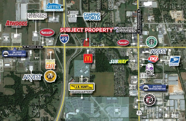

This Property Is For Sale
Property Detail
W Monroe Ave
Fayetteville-Springdale-Rogers, AR
PART OF THE SE1/4 OF THE SW OF SECTION 2, TOWNSHIP 18 NORTH, RANGE 30 WEST, BENTON COUNTY, ARKANSAS, MORE PARTICULARLY DESCRIBED AS FOLLOWS: BEGINNING AT A FOUND RAILROAD SPIKE AT THE SE CORNER OF SAID SE OF THE SW1/4; THENCE N00 0000E ALONG THE EAST
12-00190-002
BENTON
Commercialacreage
Arkansas
AE The base floodplain where base flood elevations are provided. AE Zones are now used on new format FIRMs instead of A1-A30 Zones.
2.18 AC
2025
Outlying Benton County
2025
Fayetteville/Springdale/Rogers
021406
NEARBY LISTINGS FOR SALE OR LEASE
DEMOGRAPHICS near W Monroe Ave
1 mile
3 mile
5 mile
2025 Total Population
3,590
32,753
106,879
2030 Population
3,942
36,221
117,013
Pop Growth 2025-2030
+ 9.81%
+ 10.59%
+ 9.48%
Average Age
35
35
36
2025 Total Households
1,328
11,299
35,441
HH Growth 2025-2030
+ 10.02%
+ 10.96%
+ 9.89%
Median Household Inc
$96,452
$108,923
$87,962
Avg Household Size
2.70
2.90
2.90
2025 Avg HH Vehicles
2.00
2.00
2.00
Median Home Value
$350,000
$401,709
$347,857
Median Year Built
2001
2006
2000
Nearby Places
Map Layers
Map Styles
 Street
 Aerial
Layers
 Traffic
 Biking
Places
Listings with unknown addresses are not visible on the map
- Restaurants
- Banks
- Shops
- Fitness
- Groceries
PUBLIC TRANSPORTATION
AIRPORT
Northwest Arkansas Ntl
Drive
Walk
Distance
Northwest Arkansas Ntl
25 min
11.6 mi
Nearby Properties
Address
Land Use
TOTAL SIZE
Lot Size
Zoning
Address
Land Use
TOTAL SIZE
Lot Size
Zoning
52,778 SF
1.04 AC
Address
Land Use
TOTAL SIZE
Lot Size
Zoning
367,076 SF
57.31 AC
Address
Land Use
TOTAL SIZE
Lot Size
Zoning
405,394 SF
10.97 AC
Address
Land Use
TOTAL SIZE
Lot Size
Zoning
412,893 SF
11.51 AC
Address
Land Use
TOTAL SIZE
Lot Size
Zoning
305,450 SF
12.16 AC
Address
Land Use
TOTAL SIZE
Lot Size
Zoning
365,674 SF
18.05 AC
Address
Land Use
TOTAL SIZE
Lot Size
Zoning
84,890 SF
5.89 AC
Address
Land Use
TOTAL SIZE
Lot Size
Zoning
209,369 SF
21.60 AC
Address
Land Use
TOTAL SIZE
Lot Size
Zoning
251,508 SF
30 AC
Address
Land Use
TOTAL SIZE
Lot Size
Zoning
132,494 SF
21.56 AC
Address
Land Use
TOTAL SIZE
Lot Size
Zoning
306,148 SF
48.89 AC
Address
Land Use
TOTAL SIZE
Lot Size
Zoning
191,100 SF
10.03 AC
Address
Land Use
TOTAL SIZE
Lot Size
Zoning
20,878 SF
24.78 AC
Address
Land Use
TOTAL SIZE
Lot Size
Zoning
75,610 SF
5.62 AC
Address
Land Use
TOTAL SIZE
Lot Size
Zoning
249,393 SF
10.70 AC
Address
Land Use
TOTAL SIZE
Lot Size
Zoning
292,470 SF
17.27 AC
Address
Land Use
TOTAL SIZE
Lot Size
Zoning
67,152 SF
6.28 AC
Address
Land Use
TOTAL SIZE
Lot Size
Zoning
57,715 SF
7.60 AC
Address
Land Use
TOTAL SIZE
Lot Size
Zoning
348,916 SF
24.69 AC
Address
Land Use
TOTAL SIZE
Lot Size
Zoning
29,670 SF
5.80 AC
Address
Land Use
TOTAL SIZE
Lot Size
Zoning
127,043 SF
6.82 AC
Address
Land Use
TOTAL SIZE
Lot Size
Zoning
53,503 SF
6.88 AC
Address
Land Use
TOTAL SIZE
Lot Size
Zoning
12,882 SF
12.33 AC
Address
Land Use
TOTAL SIZE
Lot Size
Zoning
62,671 SF
4.07 AC
Address
Land Use
TOTAL SIZE
Lot Size
Zoning
39,793 SF
4.94 AC
Address
Land Use
TOTAL SIZE
Lot Size
Zoning
182,415 SF
68.93 AC
Address
Land Use
TOTAL SIZE
Lot Size
Zoning
182,415 SF
12.04 AC
Address
Land Use
TOTAL SIZE
Lot Size
Zoning
39,000 SF
16.38 AC
Address
Land Use
TOTAL SIZE
Lot Size
Zoning
73,711 SF
3.59 AC
Address
Land Use
TOTAL SIZE
Lot Size
Zoning
61,012 SF
18.96 AC
The World's #1 Commercial Real Estate Marketplace
Connect with us
© 2026 CoStar Group
The information above has been obtained from sources believed reliable. While we do not doubt its accuracy we have not verified it and make no guarantee, warranty or representation about it. It is your responsibility to independently confirm its accuracy and completeness. Any projections, opinions, assumptions, or estimates used are for example only and do not represent the current or future performance of the property. The value of this transaction to you depends on tax and other factors which should be evaluated by your tax, financial, and legal advisors. You and your advisors should conduct a careful, independent investigation of the property to determine to your satisfaction the suitability of the property for your needs.