Property Record
W Pioneer Pkwy, Arlington, TX 76013
NEARBY LISTINGS FOR SALE OR LEASE
Property Detail
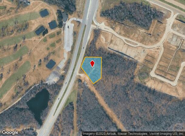
W Pioneer Pkwy
Dallas-Fort Worth-Arlington, TX
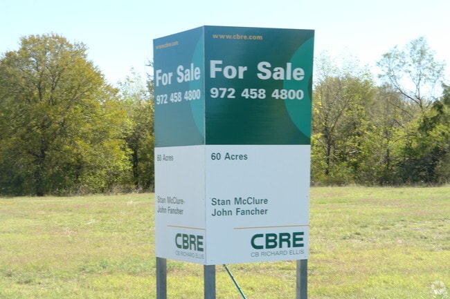
Griffin Subdivision Lot
01139568
GRIFFIN SUBDIVISION LOT 1
Residentialacreage
Tarrant
X
Texas
48439C0335K
1
2024
0.98 AC
2025
Arlington/Mansfield
122600
Dallas/Ft Worth
DEMOGRAPHICS near W Pioneer Pkwy
1 Mile
3 Mile
5 Mile
2024 Total Population
6,245
85,972
276,817
2029 Population
6,514
90,211
292,243
Pop Growth 2024-2029
+ 4.31%
+ 4.93%
+ 5.57%
Average Age
41
40
38
2024 Total Households
2,475
33,309
103,736
HH Growth 2024-2029
+ 4.28%
+ 4.97%
+ 5.62%
Median Household Inc
$77,066
$69,329
$58,554
Avg Household Size
2.50
2.50
2.60
2024 Avg HH Vehicles
2.00
2.00
2.00
Median Home Value
$296,537
$251,016
$243,926
Median Year Built
1977
1978
1979
Nearby Places
Map Layers
Map Styles
 Street
 Aerial
- Restaurants
- Banks
- Shops
- Fitness
- Groceries
PUBLIC TRANSPORTATION
COMMUTER RAIL
Hurst/Bell (TRINITY RAILWAY - Dallas Area Rapid Transit (DART), Trinity Railway Express - Dallas Area Rapid Transit (DART))
DRIVE
WALK
Distance
Hurst/Bell (TRINITY RAILWAY - Dallas Area Rapid Transit (DART), Trinity Railway Express - Dallas Area Rapid Transit (DART))
18 min
8.5 mi
Richland Hills (Trinity Railway Express - Dallas Area Rapid Transit (DART))
DRIVE
WALK
Distance
Richland Hills (Trinity Railway Express - Dallas Area Rapid Transit (DART))
13 min
8.5 mi
AIRPORT
Dallas-Fort Worth International
DRIVE
WALK
Distance
Dallas-Fort Worth International
32 min
20.9 mi
Dallas Love Field
DRIVE
WALK
Distance
Dallas Love Field
41 min
28.8 mi
Freight Ports
Port of Shreveport
DRIVE
WALK
Distance
Port of Shreveport
240 min
221.4 mi
Nearby Properties
Address
Land Use
TOTAL SIZE
Lot Size
Zoning
Address
Land Use
TOTAL SIZE
Lot Size
Zoning
569,312 SF
71.52 AC
Address
Land Use
TOTAL SIZE
Lot Size
Zoning
288,378 SF
15.40 AC
Address
Land Use
TOTAL SIZE
Lot Size
Zoning
242,811 SF
13.60 AC
Address
Land Use
TOTAL SIZE
Lot Size
Zoning
163,000 SF
12.36 AC
Address
Land Use
TOTAL SIZE
Lot Size
Zoning
268,643 SF
12.50 AC
Address
Land Use
TOTAL SIZE
Lot Size
Zoning
218,110 SF
8.85 AC
Address
Land Use
TOTAL SIZE
Lot Size
Zoning
213,824 SF
11.66 AC
Address
Land Use
TOTAL SIZE
Lot Size
Zoning
176,735 SF
10.62 AC
Address
Land Use
TOTAL SIZE
Lot Size
Zoning
204,094 SF
16.99 AC
Address
Land Use
TOTAL SIZE
Lot Size
Zoning
206,696 SF
9.92 AC
Address
Land Use
TOTAL SIZE
Lot Size
Zoning
128,208 SF
43.67 AC
Address
Land Use
TOTAL SIZE
Lot Size
Zoning
190,755 SF
33.09 AC
Address
Land Use
TOTAL SIZE
Lot Size
Zoning
187,684 SF
9.20 AC
Address
Land Use
TOTAL SIZE
Lot Size
Zoning
220,922 SF
15.32 AC
Address
Land Use
TOTAL SIZE
Lot Size
Zoning
144,164 SF
9.31 AC
Address
Land Use
TOTAL SIZE
Lot Size
Zoning
189,675 SF
8.78 AC
Address
Land Use
TOTAL SIZE
Lot Size
Zoning
117,293 SF
6.98 AC
Address
Land Use
TOTAL SIZE
Lot Size
Zoning
120,820 SF
6.39 AC
Address
Land Use
TOTAL SIZE
Lot Size
Zoning
127,090 SF
11.16 AC
Address
Land Use
TOTAL SIZE
Lot Size
Zoning
208,085 SF
12 AC
Address
Land Use
TOTAL SIZE
Lot Size
Zoning
161,934 SF
9.89 AC
Address
Land Use
TOTAL SIZE
Lot Size
Zoning
101,320 SF
5.59 AC
Address
Land Use
TOTAL SIZE
Lot Size
Zoning
194,637 SF
13.75 AC
Address
Land Use
TOTAL SIZE
Lot Size
Zoning
4,825 SF
30.22 AC
Address
Land Use
TOTAL SIZE
Lot Size
Zoning
85,001 SF
29.35 AC
Address
Land Use
TOTAL SIZE
Lot Size
Zoning
110,684 SF
7 AC
Address
Land Use
TOTAL SIZE
Lot Size
Zoning
148,020 SF
9.89 AC
Address
Land Use
TOTAL SIZE
Lot Size
Zoning
88,963 SF
4.42 AC
Address
Land Use
TOTAL SIZE
Lot Size
Zoning
86,013 SF
3.89 AC
Address
Land Use
TOTAL SIZE
Lot Size
Zoning
60,050 SF
23.04 AC
The World's #1 Commercial Real Estate Marketplace
Connect with us
© 2025 CoStar Group
The information above has been obtained from sources believed reliable. While we do not doubt its accuracy we have not verified it and make no guarantee, warranty or representation about it. It is your responsibility to independently confirm its accuracy and completeness. Any projections, opinions, assumptions, or estimates used are for example only and do not represent the current or future performance of the property. The value of this transaction to you depends on tax and other factors which should be evaluated by your tax, financial, and legal advisors. You and your advisors should conduct a careful, independent investigation of the property to determine to your satisfaction the suitability of the property for your needs.