Property Record
W Powell Rd, Powell, OH 43065
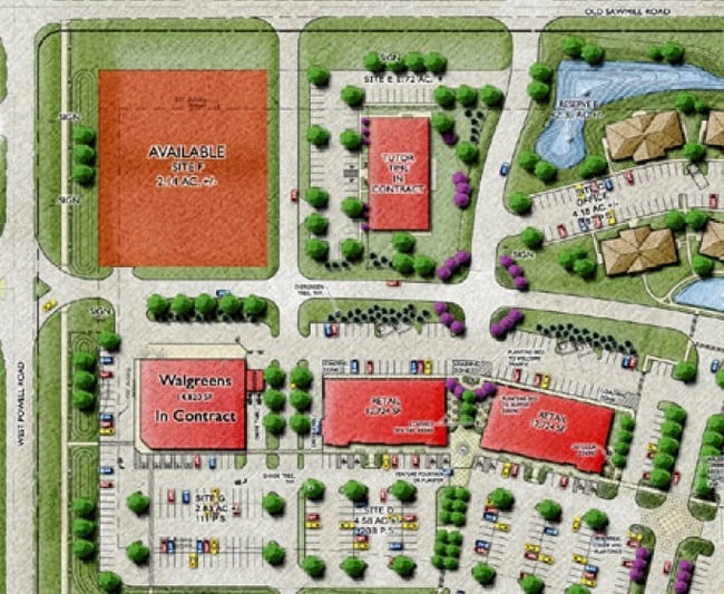
Property Detail
W Powell Rd
Columbus, OH
LANDS 19 3 4 11
318-323-13-022-000
DELAWARE
Recreationalacreage
Ohio
B and X Area of moderate flood hazard, usually the area between the limits of the 100-year and 500-year floods.
11
2024
1.08 AC
2024
Outlying Delaware County
011421
Columbus
NEARBY LISTINGS FOR SALE OR LEASE
DEMOGRAPHICS near W Powell Rd
1 mile
3 mile
5 mile
2025 Total Population
9,950
59,296
163,346
2030 Population
10,783
62,899
172,708
Pop Growth 2025-2030
+ 8.37%
+ 6.08%
+ 5.73%
Average Age
41
40
39
2025 Total Households
3,819
21,212
61,181
HH Growth 2025-2030
+ 8.48%
+ 6.05%
+ 5.70%
Median Household Inc
$156,634
$155,050
$133,514
Avg Household Size
2.60
2.80
2.60
2025 Avg HH Vehicles
2.00
2.00
2.00
Median Home Value
$491,149
$497,961
$483,564
Median Year Built
1999
1993
1994
Nearby Places
Map Layers
Map Styles
 Street
 Aerial
Transit
 Traffic
 Biking
Places
Listings with unknown addresses are not visible on the map
- Restaurants
- Banks
- Shops
- Fitness
- Groceries
PUBLIC TRANSPORTATION
AIRPORT
John Glenn Columbus International
Drive
Walk
Distance
John Glenn Columbus International
27 min
19.0 mi
Rickenbacker International
Drive
Walk
Distance
Rickenbacker International
43 min
30.4 mi
Freight Ports
Port of Toledo
Drive
Walk
Distance
Port of Toledo
163 min
130.9 mi
Nearby Properties
Address
Land Use
TOTAL SIZE
Lot Size
Zoning
Address
Land Use
TOTAL SIZE
Lot Size
Zoning
635,036 SF
45.24 AC
Address
Land Use
TOTAL SIZE
Lot Size
Zoning
443,308 SF
9 AC
Address
Land Use
TOTAL SIZE
Lot Size
Zoning
2,140,832 SF
89.50 AC
Address
Land Use
TOTAL SIZE
Lot Size
Zoning
46,994 SF
27.37 AC
Address
Land Use
TOTAL SIZE
Lot Size
Zoning
56,770 SF
22.62 AC
Address
Land Use
TOTAL SIZE
Lot Size
Zoning
295,163 SF
16.04 AC
Address
Land Use
TOTAL SIZE
Lot Size
Zoning
171,631 SF
17.55 AC
Address
Land Use
TOTAL SIZE
Lot Size
Zoning
109,480 SF
17.86 AC
Address
Land Use
TOTAL SIZE
Lot Size
Zoning
577,104 SF
31.05 AC
Address
Land Use
TOTAL SIZE
Lot Size
Zoning
116,682 SF
11.43 AC
Address
Land Use
TOTAL SIZE
Lot Size
Zoning
249,917 SF
19.18 AC
Address
Land Use
TOTAL SIZE
Lot Size
Zoning
151,248 SF
13.30 AC
Address
Land Use
TOTAL SIZE
Lot Size
Zoning
38,976 SF
22.86 AC
Address
Land Use
TOTAL SIZE
Lot Size
Zoning
266,792 SF
9.03 AC
Address
Land Use
TOTAL SIZE
Lot Size
Zoning
154,892 SF
5.86 AC
Address
Land Use
TOTAL SIZE
Lot Size
Zoning
413,781 SF
78.36 AC
Address
Land Use
TOTAL SIZE
Lot Size
Zoning
428,656 SF
6.42 AC
Address
Land Use
TOTAL SIZE
Lot Size
Zoning
70,648 SF
15.50 AC
Address
Land Use
TOTAL SIZE
Lot Size
Zoning
162,728 SF
4.80 AC
Address
Land Use
TOTAL SIZE
Lot Size
Zoning
187,562 SF
8.76 AC
Address
Land Use
TOTAL SIZE
Lot Size
Zoning
62,702 SF
38.69 AC
Address
Land Use
TOTAL SIZE
Lot Size
Zoning
219,449 SF
28.68 AC
Address
Land Use
TOTAL SIZE
Lot Size
Zoning
132,804 SF
11.54 AC
Address
Land Use
TOTAL SIZE
Lot Size
Zoning
98,872 SF
14.54 AC
Address
Land Use
TOTAL SIZE
Lot Size
Zoning
240,300 SF
12.50 AC
Address
Land Use
TOTAL SIZE
Lot Size
Zoning
165,580 SF
35.69 AC
Address
Land Use
TOTAL SIZE
Lot Size
Zoning
243,440 SF
12.50 AC
Address
Land Use
TOTAL SIZE
Lot Size
Zoning
183,424 SF
9.21 AC
Address
Land Use
TOTAL SIZE
Lot Size
Zoning
141,891 SF
43 AC
Address
Land Use
TOTAL SIZE
Lot Size
Zoning
26,534 SF
17.75 AC
The World's #1 Commercial Real Estate Marketplace
Connect with us
© 2026 CoStar Group
The information above has been obtained from sources believed reliable. While we do not doubt its accuracy we have not verified it and make no guarantee, warranty or representation about it. It is your responsibility to independently confirm its accuracy and completeness. Any projections, opinions, assumptions, or estimates used are for example only and do not represent the current or future performance of the property. The value of this transaction to you depends on tax and other factors which should be evaluated by your tax, financial, and legal advisors. You and your advisors should conduct a careful, independent investigation of the property to determine to your satisfaction the suitability of the property for your needs.