Property Record
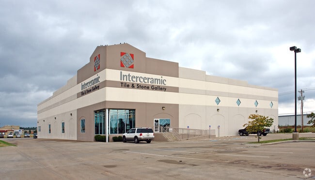
4015 W Reno Ave, Oklahoma City, OK 73107


NEARBY LISTINGS FOR SALE OR LEASE
Property Detail
4015 W Reno Ave
147826020
Unpltd Pt Sec 35 12N 4W
Warehouse
UNPLTD PT SEC 35 12N 4W 000 000 PT SE4 SEC 35 12N 4W BEG AT SW/C SE4 TH N807.82FT E662.52FT S807.31FT W662.69FT TO BEG CONT 12.2872ACRS MORE OR LESS EX THAT PT ON S FOR ROAD
X
Oklahoma
40109C0280H
Oklahoma
2023
10.60 AC
2024
West
107002
Oklahoma City
25,439 SF
Oklahoma City, OK
DEMOGRAPHICS near 4015 W Reno Ave
1 Mile
3 Mile
5 Mile
2024 Total Population
1,813
74,179
224,050
2029 Population
1,880
76,500
231,383
Pop Growth 2024-2029
+ 3.70%
+ 3.13%
+ 3.27%
Average Age
35
35
36
2024 Total Households
766
28,268
89,723
HH Growth 2024-2029
+ 3.79%
+ 3.20%
+ 3.35%
Median Household Inc
$26,077
$44,063
$46,378
Avg Household Size
2.40
2.50
2.40
2024 Avg HH Vehicles
1.00
2.00
2.00
Median Home Value
$64,285
$114,040
$133,919
Median Year Built
1959
1959
1961
Nearby Places
Map Layers
Map Styles
 Street
 Aerial
- Restaurants
- Banks
- Shops
- Fitness
- Groceries
PUBLIC TRANSPORTATION
COMMUTER RAIL
DRIVE
WALK
Distance
9 min
4.8 mi
AIRPORT
Will Rogers World
DRIVE
WALK
Distance
Will Rogers World
10 min
5.3 mi
SALE & LEASE HISTORY
LISTING DATE
SALE/LEASE

May 18, 2023
For Lease
Nearby Properties
Address
Land Use
TOTAL SIZE
Lot Size
Zoning
Address
Land Use
TOTAL SIZE
Lot Size
Zoning
246,774 SF
55.60 AC
PUD
Address
Land Use
TOTAL SIZE
Lot Size
Zoning
195,412 SF
4.42 AC
I-1
Address
Land Use
TOTAL SIZE
Lot Size
Zoning
259,726 SF
19.94 AC
PUD
Address
Land Use
TOTAL SIZE
Lot Size
Zoning
211,626 SF
12.67 AC
PUD
Address
Land Use
TOTAL SIZE
Lot Size
Zoning
279,224 SF
18.75 AC
PUD
Address
Land Use
TOTAL SIZE
Lot Size
Zoning
181,946 SF
4.42 AC
C-4
Address
Land Use
TOTAL SIZE
Lot Size
Zoning
192,771 SF
11.20 AC
I-3
Address
Land Use
TOTAL SIZE
Lot Size
Zoning
371,946 SF
31.38 AC
I-2
Address
Land Use
TOTAL SIZE
Lot Size
Zoning
336,750 SF
15.53 AC
I-3
Address
Land Use
TOTAL SIZE
Lot Size
Zoning
697,098 SF
88.91 AC
C-3
Address
Land Use
TOTAL SIZE
Lot Size
Zoning
158,150 SF
15.18 AC
I-2
Address
Land Use
TOTAL SIZE
Lot Size
Zoning
141,204 SF
6.10 AC
I-2
Address
Land Use
TOTAL SIZE
Lot Size
Zoning
246,884 SF
11.64 AC
I-2
Address
Land Use
TOTAL SIZE
Lot Size
Zoning
166,850 SF
9.97 AC
I-2
Address
Land Use
TOTAL SIZE
Lot Size
Zoning
110,391 SF
28.91 AC
I-2
Address
Land Use
TOTAL SIZE
Lot Size
Zoning
223,679 SF
40.52 AC
PUD
Address
Land Use
TOTAL SIZE
Lot Size
Zoning
258,262 SF
15.17 AC
Address
Land Use
TOTAL SIZE
Lot Size
Zoning
217,512 SF
8.79 AC
Address
Land Use
TOTAL SIZE
Lot Size
Zoning
83,055 SF
6.25 AC
PUD
Address
Land Use
TOTAL SIZE
Lot Size
Zoning
81,491 SF
15 AC
C-3
Address
Land Use
TOTAL SIZE
Lot Size
Zoning
239,654 SF
24.50 AC
PUD
Address
Land Use
TOTAL SIZE
Lot Size
Zoning
217,328 SF
11.52 AC
I-3
Address
Land Use
TOTAL SIZE
Lot Size
Zoning
208,038 SF
8.55 AC
PUD
Address
Land Use
TOTAL SIZE
Lot Size
Zoning
88,098 SF
5.94 AC
C-4
Address
Land Use
TOTAL SIZE
Lot Size
Zoning
39,860 SF
3.85 AC
I-2
Address
Land Use
TOTAL SIZE
Lot Size
Zoning
65,850 SF
6.25 AC
PUD
Address
Land Use
TOTAL SIZE
Lot Size
Zoning
75,440 SF
5.33 AC
PUD
Address
Land Use
TOTAL SIZE
Lot Size
Zoning
92,520 SF
2.28 AC
C-3
Address
Land Use
TOTAL SIZE
Lot Size
Zoning
208,400 SF
11.28 AC
I-3
Address
Land Use
TOTAL SIZE
Lot Size
Zoning
70,060 SF
50.87 AC
PUD
The World's #1 Commercial Real Estate Marketplace
Connect with us
© 2026 CoStar Group
The information above has been obtained from sources believed reliable. While we do not doubt its accuracy we have not verified it and make no guarantee, warranty or representation about it. It is your responsibility to independently confirm its accuracy and completeness. Any projections, opinions, assumptions, or estimates used are for example only and do not represent the current or future performance of the property. The value of this transaction to you depends on tax and other factors which should be evaluated by your tax, financial, and legal advisors. You and your advisors should conduct a careful, independent investigation of the property to determine to your satisfaction the suitability of the property for your needs.