Property Record
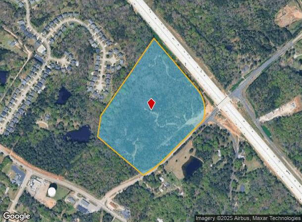
W S Koon Rd, Irmo, SC 29063
NEARBY LISTINGS FOR SALE OR LEASE
Property Detail
W S Koon Rd
03300-03-07
PARCEL A #SU #PR RB2739-347 W/S
Agriculturalland
Richland
X
South Carolina
45063C0127J
32.04 AC
2025
Dutch Fork/Irmo
2024
Columbia
010308
Columbia, SC
DEMOGRAPHICS near W S Koon Rd
1 Mile
3 Mile
5 Mile
2024 Total Population
2,229
32,500
68,560
2029 Population
2,271
33,185
70,812
Pop Growth 2024-2029
+ 1.88%
+ 2.11%
+ 3.28%
Average Age
38
40
40
2024 Total Households
825
12,283
27,351
HH Growth 2024-2029
+ 1.82%
+ 2.22%
+ 3.52%
Median Household Inc
$88,698
$92,198
$84,551
Avg Household Size
2.70
2.60
2.50
2024 Avg HH Vehicles
2.00
2.00
2.00
Median Home Value
$207,360
$226,150
$224,900
Median Year Built
2001
1993
1992
Nearby Places
Map Layers
Map Styles
 Street
 Aerial
- Restaurants
- Banks
- Shops
- Fitness
- Groceries
PUBLIC TRANSPORTATION
AIRPORT
Columbia Metro
DRIVE
WALK
Distance
Columbia Metro
32 min
18.4 mi
Freight Ports
North Charleston Terminal
DRIVE
WALK
Distance
North Charleston Terminal
132 min
114.7 mi
Nearby Properties
Address
Land Use
TOTAL SIZE
Lot Size
Zoning
Address
Land Use
TOTAL SIZE
Lot Size
Zoning
3,957 SF
20.32 AC
GC
Address
Land Use
TOTAL SIZE
Lot Size
Zoning
333,986 SF
11.33 AC
GC
Address
Land Use
TOTAL SIZE
Lot Size
Zoning
191,009 SF
28.02 AC
CG
Address
Land Use
TOTAL SIZE
Lot Size
Zoning
81,197 SF
10.34 AC
C-3
Address
Land Use
TOTAL SIZE
Lot Size
Zoning
153,210 SF
31.78 AC
LM
Address
Land Use
TOTAL SIZE
Lot Size
Zoning
75,358 SF
13.84 AC
M-1
Address
Land Use
TOTAL SIZE
Lot Size
Zoning
66,351 SF
2.20 AC
PD
Address
Land Use
TOTAL SIZE
Lot Size
Zoning
8,358 SF
9.12 AC
CG
Address
Land Use
TOTAL SIZE
Lot Size
Zoning
76,204 SF
2.26 AC
CN
Address
Land Use
TOTAL SIZE
Lot Size
Zoning
21,580 SF
16.15 AC
GC
Address
Land Use
TOTAL SIZE
Lot Size
Zoning
66,612 SF
5.56 AC
CG
Address
Land Use
TOTAL SIZE
Lot Size
Zoning
85,201 SF
48.22 AC
CG
Address
Land Use
TOTAL SIZE
Lot Size
Zoning
56,750 SF
8.16 AC
M-1
Address
Land Use
TOTAL SIZE
Lot Size
Zoning
13.81 AC
M-1
Address
Land Use
TOTAL SIZE
Lot Size
Zoning
49,840 SF
2.25 AC
CG
Address
Land Use
TOTAL SIZE
Lot Size
Zoning
76,066 SF
7.29 AC
M-1
Address
Land Use
TOTAL SIZE
Lot Size
Zoning
67,864 SF
3.94 AC
CG
Address
Land Use
TOTAL SIZE
Lot Size
Zoning
56,958 SF
6.21 AC
CG
Address
Land Use
TOTAL SIZE
Lot Size
Zoning
9.83 AC
CG
Address
Land Use
TOTAL SIZE
Lot Size
Zoning
56,588 SF
6.46 AC
GC
Address
Land Use
TOTAL SIZE
Lot Size
Zoning
15,205 SF
2.05 AC
C-3
Address
Land Use
TOTAL SIZE
Lot Size
Zoning
31,032 SF
7.36 AC
GC
Address
Land Use
TOTAL SIZE
Lot Size
Zoning
8.57 AC
CG
Address
Land Use
TOTAL SIZE
Lot Size
Zoning
15,098 SF
1.78 AC
CAC
Address
Land Use
TOTAL SIZE
Lot Size
Zoning
11,917 SF
5.72 AC
RU
Address
Land Use
TOTAL SIZE
Lot Size
Zoning
14,370 SF
6.84 AC
RU
Address
Land Use
TOTAL SIZE
Lot Size
Zoning
14,400 SF
2.31 AC
CN
Address
Land Use
TOTAL SIZE
Lot Size
Zoning
24,049 SF
5.13 AC
CG
Address
Land Use
TOTAL SIZE
Lot Size
Zoning
24,049 SF
4.30 AC
CG
Address
Land Use
TOTAL SIZE
Lot Size
Zoning
23,439 SF
7.68 AC
RU
The World's #1 Commercial Real Estate Marketplace
Connect with us
© 2026 CoStar Group
The information above has been obtained from sources believed reliable. While we do not doubt its accuracy we have not verified it and make no guarantee, warranty or representation about it. It is your responsibility to independently confirm its accuracy and completeness. Any projections, opinions, assumptions, or estimates used are for example only and do not represent the current or future performance of the property. The value of this transaction to you depends on tax and other factors which should be evaluated by your tax, financial, and legal advisors. You and your advisors should conduct a careful, independent investigation of the property to determine to your satisfaction the suitability of the property for your needs.