Property Record
W S Trotter Rd, Columbia, SC 29209
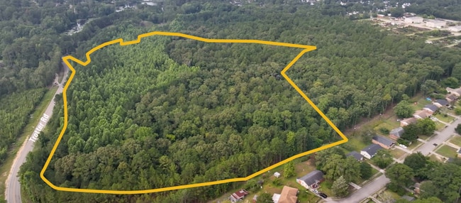
This Property Is For Sale
NEARBY LISTINGS FOR SALE OR LEASE
Property Detail
W S Trotter Rd
Columbia, SC
Pine Lakes/Hickory Ridge
22006-01-01
TRACT B #SU #PR
Agriculturalland
Richland
AE
South Carolina
45079C0382L
33.37 AC
2025
Southeast Columbia
2024
Columbia
011608
DEMOGRAPHICS near W S Trotter Rd
1 Mile
3 Mile
5 Mile
2024 Total Population
7,262
24,141
57,408
2029 Population
7,566
25,069
59,512
Pop Growth 2024-2029
+ 4.19%
+ 3.84%
+ 3.66%
Average Age
39
39
37
2024 Total Households
2,860
9,690
20,784
HH Growth 2024-2029
+ 4.27%
+ 3.95%
+ 4.05%
Median Household Inc
$56,536
$56,128
$61,184
Avg Household Size
2.50
2.40
2.30
2024 Avg HH Vehicles
2.00
2.00
2.00
Median Home Value
$167,608
$185,037
$226,101
Median Year Built
1989
1990
1990
Nearby Places
Map Layers
Map Styles
 Street
 Aerial
- Restaurants
- Banks
- Shops
- Fitness
- Groceries
PUBLIC TRANSPORTATION
AIRPORT
Columbia Metro
DRIVE
WALK
Distance
Columbia Metro
36 min
20.4 mi
Freight Ports
North Charleston Terminal
DRIVE
WALK
Distance
North Charleston Terminal
130 min
111.7 mi
Nearby Properties
Address
Land Use
TOTAL SIZE
Lot Size
Zoning
Address
Land Use
TOTAL SIZE
Lot Size
Zoning
294,105 SF
19 AC
RG-2
Address
Land Use
TOTAL SIZE
Lot Size
Zoning
212,787 SF
26.93 AC
C-3
Address
Land Use
TOTAL SIZE
Lot Size
Zoning
45,530 SF
4.72 AC
D-1
Address
Land Use
TOTAL SIZE
Lot Size
Zoning
56.15 AC
PDD
Address
Land Use
TOTAL SIZE
Lot Size
Zoning
16,140 SF
1.84 AC
PD
Address
Land Use
TOTAL SIZE
Lot Size
Zoning
255,848 SF
19.98 AC
RM-HD
Address
Land Use
TOTAL SIZE
Lot Size
Zoning
84,788 SF
5.83 AC
RM-HD
Address
Land Use
TOTAL SIZE
Lot Size
Zoning
102.68 AC
M-1
Address
Land Use
TOTAL SIZE
Lot Size
Zoning
60,772 SF
9.30 AC
GC
Address
Land Use
TOTAL SIZE
Lot Size
Zoning
51,516 SF
9.12 AC
GC
Address
Land Use
TOTAL SIZE
Lot Size
Zoning
92,918 SF
10.39 AC
M-1
Address
Land Use
TOTAL SIZE
Lot Size
Zoning
30,162 SF
3.46 AC
RS-MD
Address
Land Use
TOTAL SIZE
Lot Size
Zoning
114,660 SF
11.02 AC
RM-HD
Address
Land Use
TOTAL SIZE
Lot Size
Zoning
19,925 SF
4.34 AC
RS-LD
Address
Land Use
TOTAL SIZE
Lot Size
Zoning
91,726 SF
9.54 AC
RM-HD
Address
Land Use
TOTAL SIZE
Lot Size
Zoning
58,000 SF
5.73 AC
C-3
Address
Land Use
TOTAL SIZE
Lot Size
Zoning
13,888 SF
2 AC
PD
Address
Land Use
TOTAL SIZE
Lot Size
Zoning
84,212 SF
6.88 AC
RG-1A
Address
Land Use
TOTAL SIZE
Lot Size
Zoning
83,156 SF
4.74 AC
RG-2
Address
Land Use
TOTAL SIZE
Lot Size
Zoning
15,638 SF
1.87 AC
GC
Address
Land Use
TOTAL SIZE
Lot Size
Zoning
61,682 SF
4.92 AC
C-3
Address
Land Use
TOTAL SIZE
Lot Size
Zoning
19,465 SF
4.41 AC
RU
Address
Land Use
TOTAL SIZE
Lot Size
Zoning
25,184 SF
31 AC
M-1
Address
Land Use
TOTAL SIZE
Lot Size
Zoning
4,966 SF
2.18 AC
LI
Address
Land Use
TOTAL SIZE
Lot Size
Zoning
7,642 SF
2.42 AC
GC
Address
Land Use
TOTAL SIZE
Lot Size
Zoning
6,867 SF
1 AC
GC
Address
Land Use
TOTAL SIZE
Lot Size
Zoning
16,302 SF
1.99 AC
GC
Address
Land Use
TOTAL SIZE
Lot Size
Zoning
17,182 SF
2.89 AC
M-1
Address
Land Use
TOTAL SIZE
Lot Size
Zoning
9,591 SF
14.68 AC
RU
Address
Land Use
TOTAL SIZE
Lot Size
Zoning
12,438 SF
8.02 AC
RS-LD
The World's #1 Commercial Real Estate Marketplace
Connect with us
© 2025 CoStar Group
The information above has been obtained from sources believed reliable. While we do not doubt its accuracy we have not verified it and make no guarantee, warranty or representation about it. It is your responsibility to independently confirm its accuracy and completeness. Any projections, opinions, assumptions, or estimates used are for example only and do not represent the current or future performance of the property. The value of this transaction to you depends on tax and other factors which should be evaluated by your tax, financial, and legal advisors. You and your advisors should conduct a careful, independent investigation of the property to determine to your satisfaction the suitability of the property for your needs.