Property Record
W Scully Rd, Dwight, IL 60420
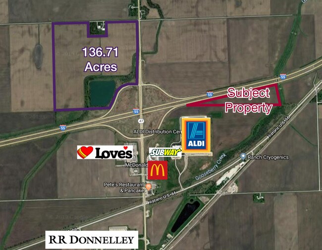

Property Detail
W Scully Rd
Chicago-Naperville-Elgin, IL-IN
NE1/4 (EX RR & 18.22 ACS FAI 55) SEC 34-31-7
11-34-200-001
GRUNDY
Agriculturalland
Illinois
AE The base floodplain where base flood elevations are provided. AE Zones are now used on new format FIRMs instead of A1-A30 Zones.
140 AC
2024
Grundy County
2024
Chicago
960100
NEARBY LISTINGS FOR SALE OR LEASE
-
-
View all Dwight listings for sale on LoopNet.com
DEMOGRAPHICS near W Scully Rd
1 mile
3 mile
5 mile
2025 Total Population
21
4,442
4,777
2030 Population
21
4,465
4,794
Pop Growth 2025-2030
0.00%
+ 0.52%
+ 0.36%
Average Age
43
43
43
2025 Total Households
8
1,862
1,995
HH Growth 2025-2030
0.00%
+ 0.48%
+ 0.30%
Median Household Inc
$124,999
$66,172
$66,951
Avg Household Size
2.50
2.30
2.30
2025 Avg HH Vehicles
2.00
2.00
2.00
Median Home Value
$225,000
$150,873
$155,833
Median Year Built
1948
1963
1962
Nearby Places
Map Layers
Map Styles
 Street
 Aerial
Layers
 Traffic
 Biking
Places
Listings with unknown addresses are not visible on the map
- Restaurants
- Banks
- Shops
- Fitness
- Groceries
PUBLIC TRANSPORTATION
COMMUTER RAIL
Dwight Amtrak Station (Lincoln Service - Amtrak, Lincoln Service Missouri River Runner - Amtrak)
Drive
Walk
Distance
Dwight Amtrak Station (Lincoln Service - Amtrak, Lincoln Service Missouri River Runner - Amtrak)
6 min
3.4 mi
Freight Ports
Port Milwaukee
Drive
Walk
Distance
Port Milwaukee
179 min
150.4 mi
SALE & LEASE HISTORY
LISTING DATE
SALE/LEASE

Jul 23, 2019
For Sale
Nearby Properties
Address
Land Use
TOTAL SIZE
Lot Size
Zoning
Address
Land Use
TOTAL SIZE
Lot Size
Zoning
124.95 AC
Address
Land Use
TOTAL SIZE
Lot Size
Zoning
266,116 SF
97.85 AC
Address
Land Use
TOTAL SIZE
Lot Size
Zoning
25,196 SF
3.43 AC
Address
Land Use
TOTAL SIZE
Lot Size
Zoning
30,714 SF
3.44 AC
Address
Land Use
TOTAL SIZE
Lot Size
Zoning
2,072 SF
21.82 AC
Address
Land Use
TOTAL SIZE
Lot Size
Zoning
3,000 SF
1.27 AC
Address
Land Use
TOTAL SIZE
Lot Size
Zoning
14,320 SF
10 AC
Address
Land Use
TOTAL SIZE
Lot Size
Zoning
2,475 SF
10.50 AC
Address
Land Use
TOTAL SIZE
Lot Size
Zoning
480 SF
0.59 AC
Address
Land Use
TOTAL SIZE
Lot Size
Zoning
8,146 SF
0.55 AC
Address
Land Use
TOTAL SIZE
Lot Size
Zoning
4,566 SF
0.21 AC
Address
Land Use
TOTAL SIZE
Lot Size
Zoning
5,574 SF
2.01 AC
Address
Land Use
TOTAL SIZE
Lot Size
Zoning
2,760 SF
1.24 AC
Address
Land Use
TOTAL SIZE
Lot Size
Zoning
10,620 SF
10.55 AC
Address
Land Use
TOTAL SIZE
Lot Size
Zoning
6,832 SF
2.59 AC
Address
Land Use
TOTAL SIZE
Lot Size
Zoning
10,160 SF
0.79 AC
Address
Land Use
TOTAL SIZE
Lot Size
Zoning
3,263 SF
0.50 AC
Address
Land Use
TOTAL SIZE
Lot Size
Zoning
340.63 AC
Address
Land Use
TOTAL SIZE
Lot Size
Zoning
4,126 SF
2.06 AC
Address
Land Use
TOTAL SIZE
Lot Size
Zoning
2,112 SF
4.56 AC
Address
Land Use
TOTAL SIZE
Lot Size
Zoning
9,516 SF
0.48 AC
Address
Land Use
TOTAL SIZE
Lot Size
Zoning
Address
Land Use
TOTAL SIZE
Lot Size
Zoning
8,820 SF
5 AC
Address
Land Use
TOTAL SIZE
Lot Size
Zoning
10,728 SF
1.93 AC
Address
Land Use
TOTAL SIZE
Lot Size
Zoning
33,800 SF
8.18 AC
Address
Land Use
TOTAL SIZE
Lot Size
Zoning
1,776 SF
0.63 AC
Address
Land Use
TOTAL SIZE
Lot Size
Zoning
9,760 SF
7.09 AC
Address
Land Use
TOTAL SIZE
Lot Size
Zoning
12,000 SF
1.06 AC
Address
Land Use
TOTAL SIZE
Lot Size
Zoning
2,560 SF
5.74 AC
Address
Land Use
TOTAL SIZE
Lot Size
Zoning
4,000 SF
0.60 AC
The World's #1 Commercial Real Estate Marketplace
Connect with us
© 2026 CoStar Group
The information above has been obtained from sources believed reliable. While we do not doubt its accuracy we have not verified it and make no guarantee, warranty or representation about it. It is your responsibility to independently confirm its accuracy and completeness. Any projections, opinions, assumptions, or estimates used are for example only and do not represent the current or future performance of the property. The value of this transaction to you depends on tax and other factors which should be evaluated by your tax, financial, and legal advisors. You and your advisors should conduct a careful, independent investigation of the property to determine to your satisfaction the suitability of the property for your needs.