Property Record
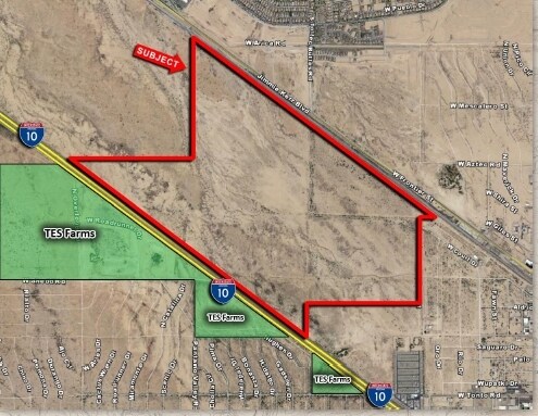
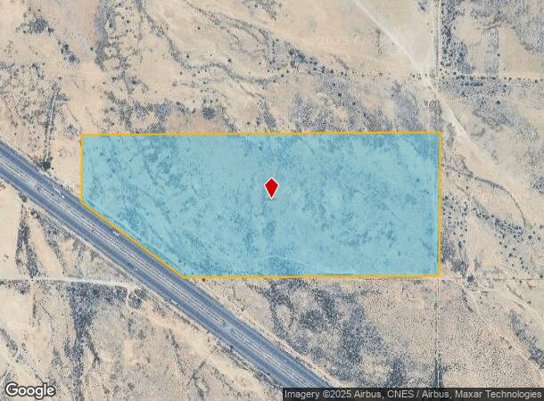
W Shedd Rd, Eloy, AZ 85131
NEARBY LISTINGS FOR SALE OR LEASE
Property Detail
W Shedd Rd
403-03-002D
BEG AT SE CR OF SEC 20-7S-7E TH W-1800' + OR - TO A PT ON E LINE OF I-10 HWY TH N-53 DEG W-1008.76' TH N-469.67' TH E-2648.20' TH S-1065.88' TO POB EXC: E-33' THEREOF 58.94 AC
Vacantlandnec
Pinal
X
Arizona
04021C1570F
58.94 AC
2024
Pinal County
2025
Phoenix
001900
Phoenix-Mesa-Scottsdale, AZ
DEMOGRAPHICS near W Shedd Rd
1 Mile
3 Mile
5 Mile
2024 Total Population
165
9,349
24,046
2029 Population
215
12,170
31,210
Pop Growth 2024-2029
+ 30.30%
+ 30.17%
+ 29.79%
Average Age
64
49
45
2024 Total Households
84
3,945
9,540
HH Growth 2024-2029
+ 29.76%
+ 30.04%
+ 29.64%
Median Household Inc
$84,375
$59,809
$54,398
Avg Household Size
1.90
2.40
2.50
2024 Avg HH Vehicles
2.00
2.00
2.00
Median Home Value
$367,142
$297,888
$194,004
Median Year Built
2010
2009
2005
Nearby Places
Map Layers
Map Styles
 Street
 Aerial
- Restaurants
- Banks
- Shops
- Fitness
- Groceries
SALE & LEASE HISTORY
LISTING DATE
SALE/LEASE

Sep 24, 2016
For Sale
May 13, 2020
For Sale
Apr 04, 2017
For Sale
Apr 03, 2017
For Sale
Nearby Properties
Address
Land Use
TOTAL SIZE
Lot Size
Zoning
Address
Land Use
TOTAL SIZE
Lot Size
Zoning
579,373 SF
32.18 AC
UNDESIGNAT
Address
Land Use
TOTAL SIZE
Lot Size
Zoning
37,469 SF
20.01 AC
UNDESIGNAT
Address
Land Use
TOTAL SIZE
Lot Size
Zoning
11,382 SF
13.33 AC
Address
Land Use
TOTAL SIZE
Lot Size
Zoning
26,328 SF
22.85 AC
UNDESIGNAT
Address
Land Use
TOTAL SIZE
Lot Size
Zoning
27.14 AC
UNDESIGNAT
Address
Land Use
TOTAL SIZE
Lot Size
Zoning
Address
Land Use
TOTAL SIZE
Lot Size
Zoning
589.97 AC
Address
Land Use
TOTAL SIZE
Lot Size
Zoning
16,305 SF
43.90 AC
UNDESIGNAT
Address
Land Use
TOTAL SIZE
Lot Size
Zoning
35,964 SF
9.40 AC
UNDESIGNAT
Address
Land Use
TOTAL SIZE
Lot Size
Zoning
16,160 SF
11.88 AC
Address
Land Use
TOTAL SIZE
Lot Size
Zoning
24,543 SF
2.28 AC
UNDESIGNAT
Address
Land Use
TOTAL SIZE
Lot Size
Zoning
53.77 AC
UNDESIGNAT
Address
Land Use
TOTAL SIZE
Lot Size
Zoning
30,420 SF
4.90 AC
CB2
Address
Land Use
TOTAL SIZE
Lot Size
Zoning
14,400 SF
40 AC
Address
Land Use
TOTAL SIZE
Lot Size
Zoning
23,640 SF
2.72 AC
Address
Land Use
TOTAL SIZE
Lot Size
Zoning
352 SF
22.81 AC
UNDESIGNAT
Address
Land Use
TOTAL SIZE
Lot Size
Zoning
16,393 SF
116.73 AC
UNDESIGNAT
Address
Land Use
TOTAL SIZE
Lot Size
Zoning
27,639 SF
2.82 AC
UNDESIGNAT
Address
Land Use
TOTAL SIZE
Lot Size
Zoning
239.09 AC
UNDESIGNAT
Address
Land Use
TOTAL SIZE
Lot Size
Zoning
9,390 SF
3.59 AC
UNDESIGNAT
Address
Land Use
TOTAL SIZE
Lot Size
Zoning
8,988 SF
0.93 AC
Address
Land Use
TOTAL SIZE
Lot Size
Zoning
5,424 SF
0.44 AC
CB1
Address
Land Use
TOTAL SIZE
Lot Size
Zoning
49,682 SF
3.16 AC
CB2
Address
Land Use
TOTAL SIZE
Lot Size
Zoning
8,453 SF
2.95 AC
CB1
Address
Land Use
TOTAL SIZE
Lot Size
Zoning
13,442 SF
1.79 AC
UNDESIGNAT
Address
Land Use
TOTAL SIZE
Lot Size
Zoning
8,320 SF
0.90 AC
Address
Land Use
TOTAL SIZE
Lot Size
Zoning
16,100 SF
8.25 AC
CI2
Address
Land Use
TOTAL SIZE
Lot Size
Zoning
5,624 SF
11.15 AC
UNDESIGNAT
The World's #1 Commercial Real Estate Marketplace
Connect with us
© 2025 CoStar Group
The information above has been obtained from sources believed reliable. While we do not doubt its accuracy we have not verified it and make no guarantee, warranty or representation about it. It is your responsibility to independently confirm its accuracy and completeness. Any projections, opinions, assumptions, or estimates used are for example only and do not represent the current or future performance of the property. The value of this transaction to you depends on tax and other factors which should be evaluated by your tax, financial, and legal advisors. You and your advisors should conduct a careful, independent investigation of the property to determine to your satisfaction the suitability of the property for your needs.