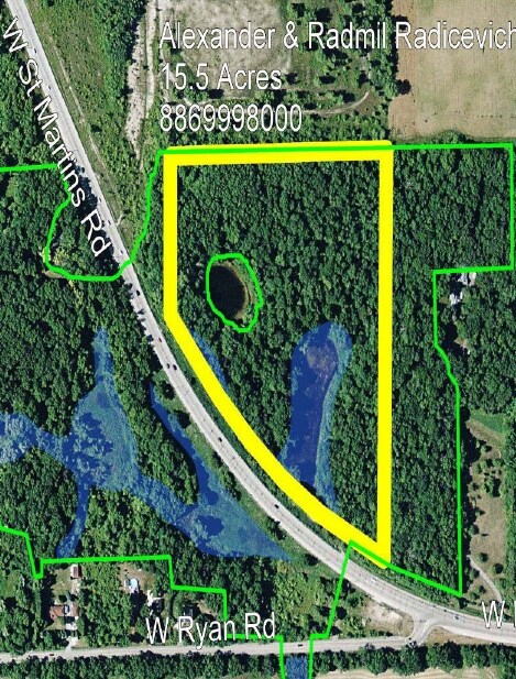
Property Record
W St Martins Rd W, Franklin, WI 53132

NEARBY LISTINGS FOR SALE OR LEASE
Property Detail
W St Martins Rd W
886-9998-000
COM 497.79 FT W & 227.68 FT N OF SE COR OF SW 21 5 21 TH
Miscellaneous
Milwaukee
X
Wisconsin
55133C0375G
15.62 AC
0
SW Outlying Milwaukee
2024
Milwaukee/Madison
150304
Milwaukee-Waukesha-West Allis, WI
DEMOGRAPHICS near W St Martins Rd W
1 Mile
3 Mile
5 Mile
2024 Total Population
2,232
20,688
64,477
2029 Population
2,162
20,194
63,211
Pop Growth 2024-2029
(3.14%)
(2.39%)
(1.96%)
Average Age
44
43
43
2024 Total Households
897
7,680
25,584
HH Growth 2024-2029
(3.34%)
(2.68%)
(2.09%)
Median Household Inc
$106,021
$109,684
$95,534
Avg Household Size
2.50
2.50
2.40
2024 Avg HH Vehicles
2.00
2.00
2.00
Median Home Value
$279,672
$327,598
$311,651
Median Year Built
1992
1990
1982
Nearby Places
Map Layers
Map Styles
 Street
 Aerial
- Restaurants
- Banks
- Shops
- Fitness
- Groceries
PUBLIC TRANSPORTATION
AIRPORT
General Mitchell International
DRIVE
WALK
Distance
General Mitchell International
18 min
11.3 mi
Freight Ports
Port Milwaukee
DRIVE
WALK
Distance
Port Milwaukee
21 min
13.6 mi
Nearby Properties
Address
Land Use
TOTAL SIZE
Lot Size
Zoning
Address
Land Use
TOTAL SIZE
Lot Size
Zoning
17.46 AC
Address
Land Use
TOTAL SIZE
Lot Size
Zoning
5.74 AC
Address
Land Use
TOTAL SIZE
Lot Size
Zoning
33.48 AC
Address
Land Use
TOTAL SIZE
Lot Size
Zoning
14.95 AC
Address
Land Use
TOTAL SIZE
Lot Size
Zoning
26.03 AC
Address
Land Use
TOTAL SIZE
Lot Size
Zoning
57,474 SF
5.07 AC
Address
Land Use
TOTAL SIZE
Lot Size
Zoning
21.21 AC
Address
Land Use
TOTAL SIZE
Lot Size
Zoning
12.45 AC
Address
Land Use
TOTAL SIZE
Lot Size
Zoning
Address
Land Use
TOTAL SIZE
Lot Size
Zoning
Address
Land Use
TOTAL SIZE
Lot Size
Zoning
Address
Land Use
TOTAL SIZE
Lot Size
Zoning
9.13 AC
Address
Land Use
TOTAL SIZE
Lot Size
Zoning
12.31 AC
Address
Land Use
TOTAL SIZE
Lot Size
Zoning
1.57 AC
Address
Land Use
TOTAL SIZE
Lot Size
Zoning
8.83 AC
Address
Land Use
TOTAL SIZE
Lot Size
Zoning
3.49 AC
Address
Land Use
TOTAL SIZE
Lot Size
Zoning
13.16 AC
Address
Land Use
TOTAL SIZE
Lot Size
Zoning
2.84 AC
Address
Land Use
TOTAL SIZE
Lot Size
Zoning
125,028 SF
9.69 AC
Address
Land Use
TOTAL SIZE
Lot Size
Zoning
100,386 SF
14.57 AC
Address
Land Use
TOTAL SIZE
Lot Size
Zoning
129,024 SF
7.61 AC
Address
Land Use
TOTAL SIZE
Lot Size
Zoning
0.98 AC
Address
Land Use
TOTAL SIZE
Lot Size
Zoning
6.93 AC
Address
Land Use
TOTAL SIZE
Lot Size
Zoning
9.30 AC
Address
Land Use
TOTAL SIZE
Lot Size
Zoning
9.09 AC
Address
Land Use
TOTAL SIZE
Lot Size
Zoning
2,912 SF
0.16 AC
Address
Land Use
TOTAL SIZE
Lot Size
Zoning
10.08 AC
Address
Land Use
TOTAL SIZE
Lot Size
Zoning
5.72 AC
Address
Land Use
TOTAL SIZE
Lot Size
Zoning
Address
Land Use
TOTAL SIZE
Lot Size
Zoning
47,146 SF
3.58 AC
The World's #1 Commercial Real Estate Marketplace
Connect with us
© 2025 CoStar Group
The information above has been obtained from sources believed reliable. While we do not doubt its accuracy we have not verified it and make no guarantee, warranty or representation about it. It is your responsibility to independently confirm its accuracy and completeness. Any projections, opinions, assumptions, or estimates used are for example only and do not represent the current or future performance of the property. The value of this transaction to you depends on tax and other factors which should be evaluated by your tax, financial, and legal advisors. You and your advisors should conduct a careful, independent investigation of the property to determine to your satisfaction the suitability of the property for your needs.