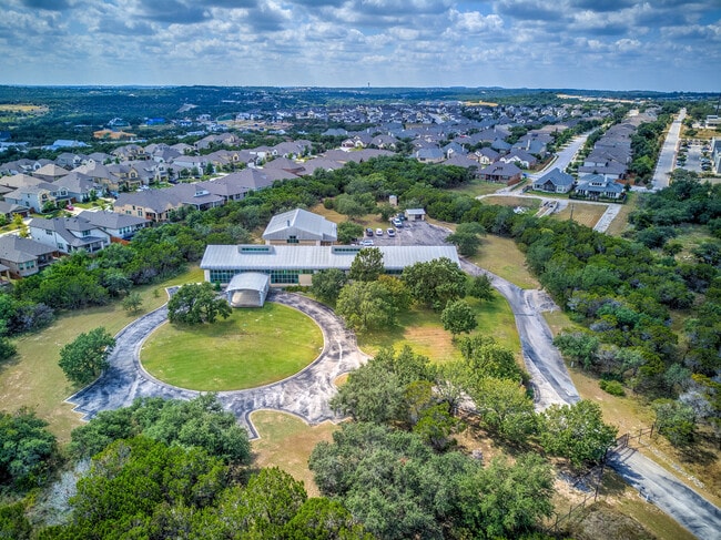
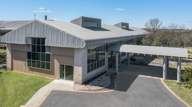
Property Record
W State Hy 71, Austin, TX 78738
This Property Is For Sale
Property Detail
W State Hy 71
Austin-Round Rock-San Marcos, TX
LOT 3 REESE ACRES
366369
TRAVIS
Vacantlandnec
Texas
B and X Area of moderate flood hazard, usually the area between the limits of the 100-year and 500-year floods.
3
2025
1.90 AC
2025
Southwest
036500
Austin
NEARBY LISTINGS FOR SALE OR LEASE
-
-
View all Austin listings for sale on LoopNet.com
DEMOGRAPHICS near W State Hy 71
1 mile
3 mile
5 mile
2025 Total Population
3,828
24,163
56,803
2030 Population
4,070
25,429
59,947
Pop Growth 2025-2030
+ 6.32%
+ 5.24%
+ 5.53%
Average Age
40
43
43
2025 Total Households
1,405
9,356
21,305
HH Growth 2025-2030
+ 6.69%
+ 5.65%
+ 6.10%
Median Household Inc
$145,312
$157,889
$174,138
Avg Household Size
2.70
2.50
2.60
2025 Avg HH Vehicles
2.00
2.00
2.00
Median Home Value
$820,715
$841,012
$846,276
Median Year Built
2011
2010
2010
Nearby Places
Map Layers
Map Styles
 Street
 Aerial
Transit
 Traffic
 Biking
Places
Listings with unknown addresses are not visible on the map
- Restaurants
- Banks
- Shops
- Fitness
- Groceries
PUBLIC TRANSPORTATION
AIRPORT
Austin-Bergstrom International
Drive
Walk
Distance
Austin-Bergstrom International
41 min
25.1 mi
Freight Ports
Calhoun Port
Drive
Walk
Distance
Calhoun Port
206 min
168.6 mi
Nearby Properties
Address
Land Use
TOTAL SIZE
Lot Size
Zoning
Address
Land Use
TOTAL SIZE
Lot Size
Zoning
826,410 SF
154.43 AC
Address
Land Use
TOTAL SIZE
Lot Size
Zoning
904,909 SF
39.39 AC
Address
Land Use
TOTAL SIZE
Lot Size
Zoning
554,062 SF
77.58 AC
Address
Land Use
TOTAL SIZE
Lot Size
Zoning
270,509 SF
8.84 AC
Address
Land Use
TOTAL SIZE
Lot Size
Zoning
329,638 SF
40.10 AC
Address
Land Use
TOTAL SIZE
Lot Size
Zoning
375,383 SF
34.13 AC
Address
Land Use
TOTAL SIZE
Lot Size
Zoning
332,908 SF
16.88 AC
Address
Land Use
TOTAL SIZE
Lot Size
Zoning
293,295 SF
9.54 AC
Address
Land Use
TOTAL SIZE
Lot Size
Zoning
267,540 SF
17.53 AC
Address
Land Use
TOTAL SIZE
Lot Size
Zoning
115,358 SF
21.04 AC
Address
Land Use
TOTAL SIZE
Lot Size
Zoning
8,711 SF
16.94 AC
Address
Land Use
TOTAL SIZE
Lot Size
Zoning
209,936 SF
5.79 AC
Address
Land Use
TOTAL SIZE
Lot Size
Zoning
157,030 SF
8.91 AC
Address
Land Use
TOTAL SIZE
Lot Size
Zoning
116,867 SF
13.94 AC
Address
Land Use
TOTAL SIZE
Lot Size
Zoning
131,175 SF
36.46 AC
Address
Land Use
TOTAL SIZE
Lot Size
Zoning
150,000 SF
13.52 AC
Address
Land Use
TOTAL SIZE
Lot Size
Zoning
265,650 SF
12.15 AC
Address
Land Use
TOTAL SIZE
Lot Size
Zoning
Address
Land Use
TOTAL SIZE
Lot Size
Zoning
121.82 AC
Address
Land Use
TOTAL SIZE
Lot Size
Zoning
110,000 SF
8.37 AC
Address
Land Use
TOTAL SIZE
Lot Size
Zoning
132,793 SF
2.76 AC
Address
Land Use
TOTAL SIZE
Lot Size
Zoning
55,468 SF
Address
Land Use
TOTAL SIZE
Lot Size
Zoning
104,303 SF
15.45 AC
Address
Land Use
TOTAL SIZE
Lot Size
Zoning
90,648 SF
8.60 AC
Address
Land Use
TOTAL SIZE
Lot Size
Zoning
42,000 SF
4.62 AC
Address
Land Use
TOTAL SIZE
Lot Size
Zoning
86,673 SF
8.19 AC
Address
Land Use
TOTAL SIZE
Lot Size
Zoning
60,907 SF
8.50 AC
Address
Land Use
TOTAL SIZE
Lot Size
Zoning
84,916 SF
17.89 AC
Address
Land Use
TOTAL SIZE
Lot Size
Zoning
173,250 SF
5.72 AC
Address
Land Use
TOTAL SIZE
Lot Size
Zoning
333.32 AC
The World's #1 Commercial Real Estate Marketplace
Connect with us
© 2026 CoStar Group
The information above has been obtained from sources believed reliable. While we do not doubt its accuracy we have not verified it and make no guarantee, warranty or representation about it. It is your responsibility to independently confirm its accuracy and completeness. Any projections, opinions, assumptions, or estimates used are for example only and do not represent the current or future performance of the property. The value of this transaction to you depends on tax and other factors which should be evaluated by your tax, financial, and legal advisors. You and your advisors should conduct a careful, independent investigation of the property to determine to your satisfaction the suitability of the property for your needs.