Property Record
W State Hy 71, Spicewood, TX 78669
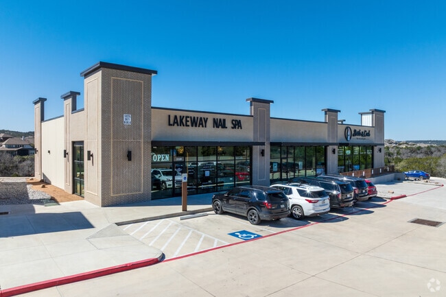

Property Detail
W State Hy 71
Austin-Round Rock-San Marcos, TX
LOT 1 BLK B SWEETWATER CENTRE PHS ONE
910322
TRAVIS
Stripcommercialcenter
Texas
B and X Area of moderate flood hazard, usually the area between the limits of the 100-year and 500-year floods.
1
2025
1.13 AC
2025
Southwest
035300
Austin
9,100 SF
NEARBY LISTINGS FOR SALE OR LEASE
DEMOGRAPHICS near W State Hy 71
1 mile
3 mile
5 mile
2025 Total Population
3,592
22,328
51,074
2030 Population
3,924
23,984
54,393
Pop Growth 2025-2030
+ 9.24%
+ 7.42%
+ 6.50%
Average Age
37
42
44
2025 Total Households
1,174
7,955
19,380
HH Growth 2025-2030
+ 9.80%
+ 7.86%
+ 7.03%
Median Household Inc
$215,409
$190,405
$171,917
Avg Household Size
3.10
2.80
2.60
2025 Avg HH Vehicles
2.00
2.00
2.00
Median Home Value
$866,893
$876,161
$816,239
Median Year Built
2011
2010
2010
Nearby Places
Map Layers
Map Styles
 Street
 Aerial
Layers
 Traffic
 Biking
Places
Listings with unknown addresses are not visible on the map
- Restaurants
- Banks
- Shops
- Fitness
- Groceries
PUBLIC TRANSPORTATION
AIRPORT
Austin-Bergstrom International
Drive
Walk
Distance
Austin-Bergstrom International
46 min
28.1 mi
SALE & LEASE HISTORY
LISTING DATE
SALE/LEASE

Apr 17, 2024
For Lease
Nearby Properties
Address
Land Use
TOTAL SIZE
Lot Size
Zoning
Address
Land Use
TOTAL SIZE
Lot Size
Zoning
375,383 SF
34.13 AC
Address
Land Use
TOTAL SIZE
Lot Size
Zoning
332,908 SF
16.88 AC
Address
Land Use
TOTAL SIZE
Lot Size
Zoning
116,867 SF
13.94 AC
Address
Land Use
TOTAL SIZE
Lot Size
Zoning
668.19 AC
Address
Land Use
TOTAL SIZE
Lot Size
Zoning
131,175 SF
36.46 AC
Address
Land Use
TOTAL SIZE
Lot Size
Zoning
121.82 AC
Address
Land Use
TOTAL SIZE
Lot Size
Zoning
4,500 SF
70 AC
Address
Land Use
TOTAL SIZE
Lot Size
Zoning
2,046 SF
323.84 AC
Address
Land Use
TOTAL SIZE
Lot Size
Zoning
50,975 SF
7.33 AC
Address
Land Use
TOTAL SIZE
Lot Size
Zoning
99,700 SF
4.40 AC
Address
Land Use
TOTAL SIZE
Lot Size
Zoning
51.81 AC
Address
Land Use
TOTAL SIZE
Lot Size
Zoning
28,320 SF
7.85 AC
Address
Land Use
TOTAL SIZE
Lot Size
Zoning
95,624 SF
5.78 AC
Address
Land Use
TOTAL SIZE
Lot Size
Zoning
250,560 SF
23.19 AC
Address
Land Use
TOTAL SIZE
Lot Size
Zoning
36,975 SF
4.40 AC
Address
Land Use
TOTAL SIZE
Lot Size
Zoning
25,200 SF
3.93 AC
Address
Land Use
TOTAL SIZE
Lot Size
Zoning
14,712 SF
2.97 AC
Address
Land Use
TOTAL SIZE
Lot Size
Zoning
2,210 SF
32.47 AC
Address
Land Use
TOTAL SIZE
Lot Size
Zoning
167.03 AC
Address
Land Use
TOTAL SIZE
Lot Size
Zoning
13.87 AC
Address
Land Use
TOTAL SIZE
Lot Size
Zoning
24,564 SF
3.27 AC
Address
Land Use
TOTAL SIZE
Lot Size
Zoning
58,292 SF
14.71 AC
Address
Land Use
TOTAL SIZE
Lot Size
Zoning
35,930 SF
18.58 AC
Address
Land Use
TOTAL SIZE
Lot Size
Zoning
35,594 SF
162.71 AC
Address
Land Use
TOTAL SIZE
Lot Size
Zoning
29,064 SF
9.84 AC
Address
Land Use
TOTAL SIZE
Lot Size
Zoning
10,142 SF
33.12 AC
Address
Land Use
TOTAL SIZE
Lot Size
Zoning
12,592 SF
24.61 AC
Address
Land Use
TOTAL SIZE
Lot Size
Zoning
10,022 SF
2.01 AC
Address
Land Use
TOTAL SIZE
Lot Size
Zoning
125,150 SF
22.12 AC
Address
Land Use
TOTAL SIZE
Lot Size
Zoning
27.04 AC
The World's #1 Commercial Real Estate Marketplace
Connect with us
© 2026 CoStar Group
The information above has been obtained from sources believed reliable. While we do not doubt its accuracy we have not verified it and make no guarantee, warranty or representation about it. It is your responsibility to independently confirm its accuracy and completeness. Any projections, opinions, assumptions, or estimates used are for example only and do not represent the current or future performance of the property. The value of this transaction to you depends on tax and other factors which should be evaluated by your tax, financial, and legal advisors. You and your advisors should conduct a careful, independent investigation of the property to determine to your satisfaction the suitability of the property for your needs.