Property Record
W State Road 45, Bloomington, IN 47403
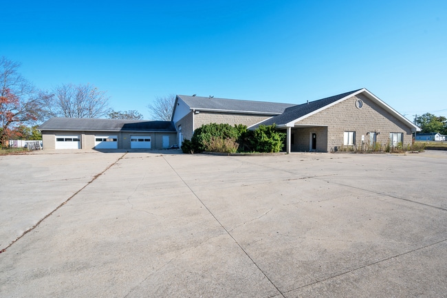
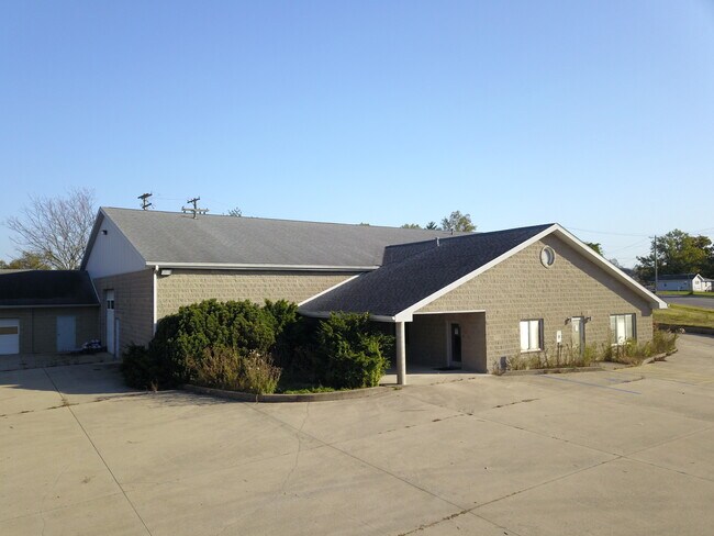
Property Detail
W State Road 45
Bloomington, IN
GOODMAN PT LOT 3 (1.06A)
53-09-14-101-010.000-015
MONROE
Commercialacreage
Indiana
LB
3
B and X Area of moderate flood hazard, usually the area between the limits of the 100-year and 500-year floods.
0.38 AC
2024
Bloomington/Terre Haute
2025
Other Market Areas
000502
NEARBY LISTINGS FOR SALE OR LEASE
-
-
View all Bloomington listings for lease on LoopNet.com
DEMOGRAPHICS near W State Road 45
1 mile
3 mile
5 mile
2025 Total Population
2,022
19,217
70,798
2030 Population
1,920
18,400
70,683
Pop Growth 2025-2030
(5.04%)
(4.25%)
(0.16%)
Average Age
41
39
36
2025 Total Households
853
8,566
32,090
HH Growth 2025-2030
(5.16%)
(4.40%)
(0.22%)
Median Household Inc
$73,268
$72,134
$52,269
Avg Household Size
2.40
2.20
2.10
2025 Avg HH Vehicles
2.00
2.00
2.00
Median Home Value
$187,233
$260,872
$272,194
Median Year Built
1979
1990
1988
Nearby Places
Map Layers
Map Styles
 Street
 Aerial
Layers
 Traffic
 Biking
Places
Listings with unknown addresses are not visible on the map
- Restaurants
- Banks
- Shops
- Fitness
- Groceries
SALE & LEASE HISTORY
LISTING DATE
SALE/LEASE

Sep 30, 2025
For Lease
Oct 19, 2023
For Lease
Dec 19, 2024
For Lease
Apr 29, 2025
For Sale
Nearby Properties
Address
Land Use
TOTAL SIZE
Lot Size
Zoning
Address
Land Use
TOTAL SIZE
Lot Size
Zoning
318,600 SF
43.80 AC
IL
Address
Land Use
TOTAL SIZE
Lot Size
Zoning
19,128 SF
24.44 AC
Address
Land Use
TOTAL SIZE
Lot Size
Zoning
60,434 SF
29.85 AC
IG
Address
Land Use
TOTAL SIZE
Lot Size
Zoning
87,842 SF
11.14 AC
GB
Address
Land Use
TOTAL SIZE
Lot Size
Zoning
64,798 SF
18.32 AC
RE1
Address
Land Use
TOTAL SIZE
Lot Size
Zoning
576 SF
13 AC
Address
Land Use
TOTAL SIZE
Lot Size
Zoning
14,376 SF
11.03 AC
Address
Land Use
TOTAL SIZE
Lot Size
Zoning
19,623 SF
8.21 AC
Address
Land Use
TOTAL SIZE
Lot Size
Zoning
1,120 SF
11.95 AC
Address
Land Use
TOTAL SIZE
Lot Size
Zoning
126,046 SF
19.03 AC
IL
Address
Land Use
TOTAL SIZE
Lot Size
Zoning
218,783 SF
24.97 AC
GB
Address
Land Use
TOTAL SIZE
Lot Size
Zoning
40,960 SF
11.76 AC
PUD
Address
Land Use
TOTAL SIZE
Lot Size
Zoning
17,950 SF
12.06 AC
Address
Land Use
TOTAL SIZE
Lot Size
Zoning
97,912 SF
86.62 AC
Address
Land Use
TOTAL SIZE
Lot Size
Zoning
19,800 SF
12.08 AC
Address
Land Use
TOTAL SIZE
Lot Size
Zoning
11,488 SF
14.33 AC
Address
Land Use
TOTAL SIZE
Lot Size
Zoning
22,280 SF
4.52 AC
Address
Land Use
TOTAL SIZE
Lot Size
Zoning
89,376 SF
6.26 AC
Address
Land Use
TOTAL SIZE
Lot Size
Zoning
2,715 SF
22.92 AC
Address
Land Use
TOTAL SIZE
Lot Size
Zoning
17,550 SF
9.05 AC
Address
Land Use
TOTAL SIZE
Lot Size
Zoning
69,297 SF
7.67 AC
IG
Address
Land Use
TOTAL SIZE
Lot Size
Zoning
186,192 SF
20.04 AC
PUD
Address
Land Use
TOTAL SIZE
Lot Size
Zoning
7,444 SF
70.20 AC
IG
Address
Land Use
TOTAL SIZE
Lot Size
Zoning
147,420 SF
20.33 AC
IL
Address
Land Use
TOTAL SIZE
Lot Size
Zoning
2,562 SF
8.09 AC
RM15
Address
Land Use
TOTAL SIZE
Lot Size
Zoning
25,749 SF
10.77 AC
Address
Land Use
TOTAL SIZE
Lot Size
Zoning
3,600 SF
15.59 AC
Address
Land Use
TOTAL SIZE
Lot Size
Zoning
843,333 SF
23.10 AC
IG
Address
Land Use
TOTAL SIZE
Lot Size
Zoning
6,600 SF
9.84 AC
Address
Land Use
TOTAL SIZE
Lot Size
Zoning
52,802 SF
6.24 AC
PUD
The World's #1 Commercial Real Estate Marketplace
Connect with us
© 2026 CoStar Group
The information above has been obtained from sources believed reliable. While we do not doubt its accuracy we have not verified it and make no guarantee, warranty or representation about it. It is your responsibility to independently confirm its accuracy and completeness. Any projections, opinions, assumptions, or estimates used are for example only and do not represent the current or future performance of the property. The value of this transaction to you depends on tax and other factors which should be evaluated by your tax, financial, and legal advisors. You and your advisors should conduct a careful, independent investigation of the property to determine to your satisfaction the suitability of the property for your needs.