Property Record
29401 E 32Nd St S, Broken Arrow, OK 74014
NEARBY LISTINGS FOR SALE OR LEASE
Property Detail
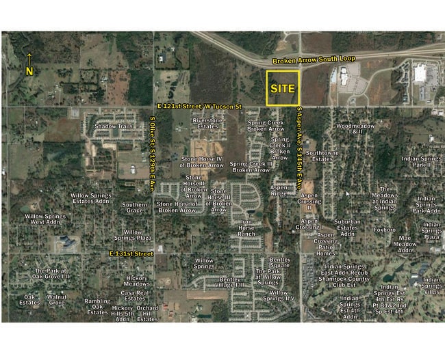
29401 E 32Nd St S
Tulsa, OK
Unplatted
98433-84-33-56010
E/2 SE LYING S OF TURNPIKE ROW LESS S24.75 & E24.75 THEREOF & LESS BEG 24.75N & 24.75W SECR SE SE TH W325.21 N20.25 E275.02 NE35.32 N686.67 SELY180.67 E5.25 S552.29 TO POB SEC 33 18 14 33.920ACS
Agriculturalland
Tulsa
A
Oklahoma
40143C0452M
33.92 AC
2023
Southeast
2024
Tulsa
007531
DEMOGRAPHICS near 29401 E 32Nd St S
1 Mile
3 Mile
5 Mile
2024 Total Population
5,039
45,563
108,040
2029 Population
5,332
47,046
112,030
Pop Growth 2024-2029
+ 5.81%
+ 3.25%
+ 3.69%
Average Age
38
39
39
2024 Total Households
1,926
17,005
40,406
HH Growth 2024-2029
+ 5.66%
+ 3.28%
+ 3.69%
Median Household Inc
$85,896
$84,441
$84,043
Avg Household Size
2.60
2.60
2.60
2024 Avg HH Vehicles
2.00
2.00
2.00
Median Home Value
$228,656
$217,183
$229,131
Median Year Built
2001
1988
1990
Nearby Places
- Restaurants
- Banks
- Shops
- Fitness
- Groceries
PUBLIC TRANSPORTATION
AIRPORT
Tulsa International
DRIVE
WALK
Distance
Tulsa International
28 min
20.2 mi
Freight Ports
Tulsa Port of Inola
DRIVE
WALK
Distance
Tulsa Port of Inola
37 min
31.2 mi
SALE & LEASE HISTORY
LISTING DATE
SALE/LEASE

Oct 31, 2024
For Sale
May 25, 2021
For Sale
Nearby Properties
Address
Land Use
TOTAL SIZE
Lot Size
Zoning
Address
Land Use
TOTAL SIZE
Lot Size
Zoning
390,154 SF
52.94 AC
A1
Address
Land Use
TOTAL SIZE
Lot Size
Zoning
73,113 SF
28.52 AC
R2
Address
Land Use
TOTAL SIZE
Lot Size
Zoning
64,283 SF
29.41 AC
A1
Address
Land Use
TOTAL SIZE
Lot Size
Zoning
21,301 SF
3.94 AC
CN
Address
Land Use
TOTAL SIZE
Lot Size
Zoning
84,314 SF
12.05 AC
A1
Address
Land Use
TOTAL SIZE
Lot Size
Zoning
35,954 SF
27.97 AC
CN
Address
Land Use
TOTAL SIZE
Lot Size
Zoning
67,490 SF
5.40 AC
RM
Address
Land Use
TOTAL SIZE
Lot Size
Zoning
39,733 SF
9.36 AC
A1
Address
Land Use
TOTAL SIZE
Lot Size
Zoning
54,129 SF
4.83 AC
NCU
Address
Land Use
TOTAL SIZE
Lot Size
Zoning
71,143 SF
4.43 AC
R1
Address
Land Use
TOTAL SIZE
Lot Size
Zoning
245,436 SF
12.21 AC
RM
Address
Land Use
TOTAL SIZE
Lot Size
Zoning
33,669 SF
4.64 AC
A1
Address
Land Use
TOTAL SIZE
Lot Size
Zoning
28,303 SF
16.76 AC
CN
Address
Land Use
TOTAL SIZE
Lot Size
Zoning
3,300 SF
40 AC
A1
Address
Land Use
TOTAL SIZE
Lot Size
Zoning
27,531 SF
4.46 AC
R2
Address
Land Use
TOTAL SIZE
Lot Size
Zoning
28,226 SF
8.26 AC
CN
Address
Land Use
TOTAL SIZE
Lot Size
Zoning
12,940 SF
123.64 AC
R2
Address
Land Use
TOTAL SIZE
Lot Size
Zoning
222,536 SF
11.31 AC
CN
Address
Land Use
TOTAL SIZE
Lot Size
Zoning
11,261 SF
2.85 AC
CN
Address
Land Use
TOTAL SIZE
Lot Size
Zoning
30,482 SF
4.43 AC
R1
Address
Land Use
TOTAL SIZE
Lot Size
Zoning
Address
Land Use
TOTAL SIZE
Lot Size
Zoning
33,181 SF
4.54 AC
R1
Address
Land Use
TOTAL SIZE
Lot Size
Zoning
279,632 SF
14.54 AC
RM
Address
Land Use
TOTAL SIZE
Lot Size
Zoning
11,100 SF
5.30 AC
R1
Address
Land Use
TOTAL SIZE
Lot Size
Zoning
11,923 SF
6.11 AC
A1
Address
Land Use
TOTAL SIZE
Lot Size
Zoning
25,615 SF
4.62 AC
A1
Address
Land Use
TOTAL SIZE
Lot Size
Zoning
24,830 SF
5.15 AC
R2
Address
Land Use
TOTAL SIZE
Lot Size
Zoning
210,976 SF
22.52 AC
CG
Address
Land Use
TOTAL SIZE
Lot Size
Zoning
50,086 SF
2.58 AC
CG
Address
Land Use
TOTAL SIZE
Lot Size
Zoning
23,587 SF
6.90 AC
R3
The World's #1 Commercial Real Estate Marketplace
Connect with us
© 2025 CoStar Group
The information above has been obtained from sources believed reliable. While we do not doubt its accuracy we have not verified it and make no guarantee, warranty or representation about it. It is your responsibility to independently confirm its accuracy and completeness. Any projections, opinions, assumptions, or estimates used are for example only and do not represent the current or future performance of the property. The value of this transaction to you depends on tax and other factors which should be evaluated by your tax, financial, and legal advisors. You and your advisors should conduct a careful, independent investigation of the property to determine to your satisfaction the suitability of the property for your needs.