Property Record
W Us 380, Ponder, TX 76259


Property Detail
W Us 380
Dallas-Fort Worth-Arlington, TX
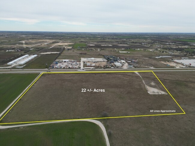
A0516A HALLMARK, TR 21, 27.5027 ACRES
R67267
DENTON
Agriculturalland
Texas
B and X Area of moderate flood hazard, usually the area between the limits of the 100-year and 500-year floods.
11
2024
27.50 AC
2025
Outlying Denton County
020313
Dallas/Ft Worth
NEARBY LISTINGS FOR SALE OR LEASE
DEMOGRAPHICS near W Us 380
1 mile
3 mile
5 mile
2024 Total Population
212
2,615
6,588
2029 Population
253
3,131
7,920
Pop Growth 2024-2029
+ 19.34%
+ 19.73%
+ 20.22%
Average Age
41
40
40
2024 Total Households
73
884
2,216
HH Growth 2024-2029
+ 20.55%
+ 20.25%
+ 20.71%
Median Household Inc
$68,499
$78,143
$86,802
Avg Household Size
2.90
2.90
2.90
2024 Avg HH Vehicles
3.00
3.00
3.00
Median Home Value
$420,588
$401,020
$360,585
Median Year Built
1996
2000
2001
Nearby Places
Map Layers
Map Styles
 Street
 Aerial
Transit
 Traffic
 Biking
Places
Listings with unknown addresses are not visible on the map
- Restaurants
- Banks
- Shops
- Fitness
- Groceries
PUBLIC TRANSPORTATION
AIRPORT
Dallas-Fort Worth International
Drive
Walk
Distance
Dallas-Fort Worth International
45 min
37.8 mi
Freight Ports
Tulsa Port of Inola
Drive
Walk
Distance
Tulsa Port of Inola
316 min
279.9 mi
SALE & LEASE HISTORY
LISTING DATE
SALE/LEASE

Feb 12, 2024
For Sale
Nearby Properties
Address
Land Use
TOTAL SIZE
Lot Size
Zoning
Address
Land Use
TOTAL SIZE
Lot Size
Zoning
53,384 SF
19.62 AC
Address
Land Use
TOTAL SIZE
Lot Size
Zoning
81,856 SF
30 AC
Address
Land Use
TOTAL SIZE
Lot Size
Zoning
21,000 SF
20.42 AC
Address
Land Use
TOTAL SIZE
Lot Size
Zoning
23,082 SF
4 AC
Address
Land Use
TOTAL SIZE
Lot Size
Zoning
336 SF
28.59 AC
Address
Land Use
TOTAL SIZE
Lot Size
Zoning
60,000 SF
7.36 AC
Address
Land Use
TOTAL SIZE
Lot Size
Zoning
48,400 SF
10.30 AC
Address
Land Use
TOTAL SIZE
Lot Size
Zoning
146.99 AC
Address
Land Use
TOTAL SIZE
Lot Size
Zoning
9,258 SF
4 AC
Address
Land Use
TOTAL SIZE
Lot Size
Zoning
6,450 SF
17.63 AC
Address
Land Use
TOTAL SIZE
Lot Size
Zoning
5,500 SF
12.65 AC
Address
Land Use
TOTAL SIZE
Lot Size
Zoning
30 AC
Address
Land Use
TOTAL SIZE
Lot Size
Zoning
41 SF
21.76 AC
Address
Land Use
TOTAL SIZE
Lot Size
Zoning
16,250 SF
6.89 AC
Address
Land Use
TOTAL SIZE
Lot Size
Zoning
9,000 SF
11.61 AC
Address
Land Use
TOTAL SIZE
Lot Size
Zoning
25,175 SF
7.98 AC
Address
Land Use
TOTAL SIZE
Lot Size
Zoning
1,080 SF
70.74 AC
Address
Land Use
TOTAL SIZE
Lot Size
Zoning
10.93 AC
Address
Land Use
TOTAL SIZE
Lot Size
Zoning
8,435 SF
9.05 AC
Address
Land Use
TOTAL SIZE
Lot Size
Zoning
4,558 SF
4.81 AC
Address
Land Use
TOTAL SIZE
Lot Size
Zoning
14.69 AC
Address
Land Use
TOTAL SIZE
Lot Size
Zoning
1,064 SF
58.20 AC
Address
Land Use
TOTAL SIZE
Lot Size
Zoning
18,200 SF
10.03 AC
Address
Land Use
TOTAL SIZE
Lot Size
Zoning
7,200 SF
2.05 AC
Address
Land Use
TOTAL SIZE
Lot Size
Zoning
3,367 SF
8 AC
Address
Land Use
TOTAL SIZE
Lot Size
Zoning
3,374 SF
10 AC
Address
Land Use
TOTAL SIZE
Lot Size
Zoning
5,719 SF
30 AC
Address
Land Use
TOTAL SIZE
Lot Size
Zoning
47.31 AC
Address
Land Use
TOTAL SIZE
Lot Size
Zoning
7,875 SF
3.96 AC
The World's #1 Commercial Real Estate Marketplace
Connect with us
© 2026 CoStar Group
The information above has been obtained from sources believed reliable. While we do not doubt its accuracy we have not verified it and make no guarantee, warranty or representation about it. It is your responsibility to independently confirm its accuracy and completeness. Any projections, opinions, assumptions, or estimates used are for example only and do not represent the current or future performance of the property. The value of this transaction to you depends on tax and other factors which should be evaluated by your tax, financial, and legal advisors. You and your advisors should conduct a careful, independent investigation of the property to determine to your satisfaction the suitability of the property for your needs.