Property Record
W Us Highway 98 W, Santa Rosa Beach, FL 32459

NEARBY LISTINGS FOR SALE OR LEASE
-
-
View all Santa Rosa Beach listings for sale on LoopNet.com
Property Detail
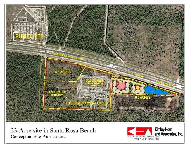
W Us Highway 98 W
Crestview-Fort Walton Beach-Destin, FL
Santa Rosa
36-2S-20-33290-000-0620
LOTS 62 & 63 SANTA ROSA PLANTATION IN SEC 36-2S-20W PB 2-4 OR 2328-866 OR 2606-4040 &-4042 OR 2919-3414 OR 3030-3583 OR 3107-2584
Vacantlandnec
Walton
A
Florida
12131C0677H
62,63
2025
10.53 AC
2025
Florida Panhandle Area
950606
Other Market Areas
DEMOGRAPHICS near W Us Highway 98 W
1 Mile
3 Mile
5 Mile
2024 Total Population
264
11,492
16,448
2029 Population
327
14,733
20,975
Pop Growth 2024-2029
+ 23.86%
+ 28.20%
+ 27.52%
Average Age
38
42
41
2024 Total Households
105
4,583
6,551
HH Growth 2024-2029
+ 23.81%
+ 28.74%
+ 28.04%
Median Household Inc
$69,107
$73,455
$74,217
Avg Household Size
2.50
2.40
2.40
2024 Avg HH Vehicles
2.00
2.00
2.00
Median Home Value
$521,429
$461,624
$454,062
Median Year Built
2007
2002
2003
Nearby Places
Map Layers
Map Styles
 Street
 Aerial
- Restaurants
- Banks
- Shops
- Fitness
- Groceries
PUBLIC TRANSPORTATION
AIRPORT
Eglin AFB/Destin-Ft Walton Beach
DRIVE
WALK
Distance
Eglin AFB/Destin-Ft Walton Beach
66 min
31.1 mi
Northwest Florida Beaches International
DRIVE
WALK
Distance
Northwest Florida Beaches International
49 min
34.7 mi
Freight Ports
Port of Panama City
DRIVE
WALK
Distance
Port of Panama City
49 min
33.0 mi
Nearby Properties
Address
Land Use
TOTAL SIZE
Lot Size
Zoning
Address
Land Use
TOTAL SIZE
Lot Size
Zoning
191,948 SF
45.59 AC
3310
Address
Land Use
TOTAL SIZE
Lot Size
Zoning
312,685 SF
28.42 AC
SMNBHD
Address
Land Use
TOTAL SIZE
Lot Size
Zoning
269,585 SF
14.50 AC
SMNBHD
Address
Land Use
TOTAL SIZE
Lot Size
Zoning
210,258 SF
20.45 AC
TC1
Address
Land Use
TOTAL SIZE
Lot Size
Zoning
200,408 SF
10.73 AC
VMU
Address
Land Use
TOTAL SIZE
Lot Size
Zoning
17,317 SF
65.65 AC
GULFFR
Address
Land Use
TOTAL SIZE
Lot Size
Zoning
154,979 SF
9.92 AC
TC1
Address
Land Use
TOTAL SIZE
Lot Size
Zoning
2.27 AC
GULFFR
Address
Land Use
TOTAL SIZE
Lot Size
Zoning
0.87 AC
GULFFR
Address
Land Use
TOTAL SIZE
Lot Size
Zoning
109,317 SF
10 AC
TC1
Address
Land Use
TOTAL SIZE
Lot Size
Zoning
483 SF
4.15 AC
GULFFR
Address
Land Use
TOTAL SIZE
Lot Size
Zoning
73,257 SF
10.62 AC
HWY 98
Address
Land Use
TOTAL SIZE
Lot Size
Zoning
Address
Land Use
TOTAL SIZE
Lot Size
Zoning
83,492 SF
7.25 AC
HWY 98
Address
Land Use
TOTAL SIZE
Lot Size
Zoning
2.44 AC
GULFFR
Address
Land Use
TOTAL SIZE
Lot Size
Zoning
112,780 SF
5.73 AC
VMU
Address
Land Use
TOTAL SIZE
Lot Size
Zoning
14,291 SF
59.59 AC
Address
Land Use
TOTAL SIZE
Lot Size
Zoning
0.78 AC
GULFFR
Address
Land Use
TOTAL SIZE
Lot Size
Zoning
2.30 AC
VMU
Address
Land Use
TOTAL SIZE
Lot Size
Zoning
54,208 SF
9.75 AC
NBHDIN
Address
Land Use
TOTAL SIZE
Lot Size
Zoning
5,494 SF
0.84 AC
GULFFR
Address
Land Use
TOTAL SIZE
Lot Size
Zoning
7,152 SF
0.91 AC
Address
Land Use
TOTAL SIZE
Lot Size
Zoning
50,793 SF
23.08 AC
3310
Address
Land Use
TOTAL SIZE
Lot Size
Zoning
4.23 AC
GULFFR
Address
Land Use
TOTAL SIZE
Lot Size
Zoning
9,870 SF
0.66 AC
GULFFR
Address
Land Use
TOTAL SIZE
Lot Size
Zoning
23,073 SF
3.12 AC
HWY 98
Address
Land Use
TOTAL SIZE
Lot Size
Zoning
1.16 AC
GULFFR
Address
Land Use
TOTAL SIZE
Lot Size
Zoning
32,601 SF
5 AC
SN
Address
Land Use
TOTAL SIZE
Lot Size
Zoning
0.57 AC
LKDUNE
Address
Land Use
TOTAL SIZE
Lot Size
Zoning
53,732 SF
9.54 AC
The World's #1 Commercial Real Estate Marketplace
Connect with us
© 2025 CoStar Group
The information above has been obtained from sources believed reliable. While we do not doubt its accuracy we have not verified it and make no guarantee, warranty or representation about it. It is your responsibility to independently confirm its accuracy and completeness. Any projections, opinions, assumptions, or estimates used are for example only and do not represent the current or future performance of the property. The value of this transaction to you depends on tax and other factors which should be evaluated by your tax, financial, and legal advisors. You and your advisors should conduct a careful, independent investigation of the property to determine to your satisfaction the suitability of the property for your needs.