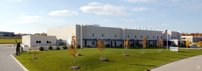
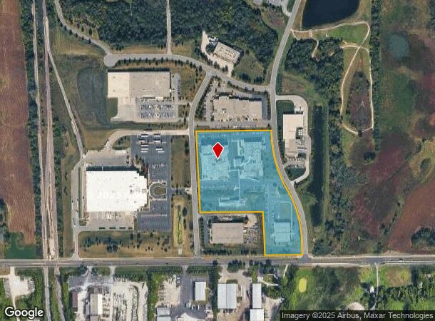
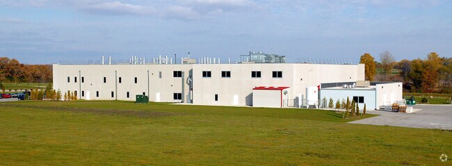
Property Record
W132n10550 Grant Dr, Germantown, WI 53022

NEARBY LISTINGS FOR SALE OR LEASE
Property Detail
W132n10550 Grant Dr
Milwaukee-Waukesha-West Allis, WI
Certified Suvey Map No 6249
GTNV-254973
PT OF SE SW+SW SE CSM 6641 LOT 1DOC 1347811+1197093+1193208+1151213
Industrialgeneral
Washington
AE
Wisconsin
55089C0230G
1
2024
12.23 AC
2024
Washington East
470204
Milwaukee/Madison
DEMOGRAPHICS near W132n10550 Grant Dr
1 Mile
3 Mile
5 Mile
2024 Total Population
2,398
24,367
74,545
2029 Population
2,407
24,216
74,479
Pop Growth 2024-2029
+ 0.38%
(0.62%)
(0.09%)
Average Age
41
40
42
2024 Total Households
815
10,011
31,333
HH Growth 2024-2029
+ 0.37%
(0.97%)
(0.17%)
Median Household Inc
$129,451
$84,210
$78,110
Avg Household Size
2.90
2.40
2.30
2024 Avg HH Vehicles
2.00
2.00
2.00
Median Home Value
$370,599
$306,166
$283,896
Median Year Built
1995
1985
1978
Nearby Places
- Restaurants
- Banks
- Shops
- Fitness
- Groceries
PUBLIC TRANSPORTATION
AIRPORT
General Mitchell International
DRIVE
WALK
Distance
General Mitchell International
43 min
26.4 mi
Freight Ports
Port Milwaukee
DRIVE
WALK
Distance
Port Milwaukee
37 min
22.6 mi
Nearby Properties
Address
Land Use
TOTAL SIZE
Lot Size
Zoning
Address
Land Use
TOTAL SIZE
Lot Size
Zoning
530,458 SF
26.32 AC
Address
Land Use
TOTAL SIZE
Lot Size
Zoning
Address
Land Use
TOTAL SIZE
Lot Size
Zoning
211,754 SF
30.52 AC
Address
Land Use
TOTAL SIZE
Lot Size
Zoning
13,717 SF
21.84 AC
IL1
Address
Land Use
TOTAL SIZE
Lot Size
Zoning
36,042 SF
4.51 AC
Address
Land Use
TOTAL SIZE
Lot Size
Zoning
222,112 SF
23.49 AC
Address
Land Use
TOTAL SIZE
Lot Size
Zoning
292,944 SF
17.32 AC
Address
Land Use
TOTAL SIZE
Lot Size
Zoning
94,698 SF
10.67 AC
Address
Land Use
TOTAL SIZE
Lot Size
Zoning
91,708 SF
6.66 AC
Address
Land Use
TOTAL SIZE
Lot Size
Zoning
204,175 SF
2.48 AC
Address
Land Use
TOTAL SIZE
Lot Size
Zoning
147,240 SF
2.53 AC
Address
Land Use
TOTAL SIZE
Lot Size
Zoning
147,240 SF
3.06 AC
Address
Land Use
TOTAL SIZE
Lot Size
Zoning
23.77 AC
Address
Land Use
TOTAL SIZE
Lot Size
Zoning
24.02 AC
Address
Land Use
TOTAL SIZE
Lot Size
Zoning
Address
Land Use
TOTAL SIZE
Lot Size
Zoning
127,496 SF
2.88 AC
Address
Land Use
TOTAL SIZE
Lot Size
Zoning
427 SF
35.16 AC
IL1
Address
Land Use
TOTAL SIZE
Lot Size
Zoning
147,987 SF
15.23 AC
Address
Land Use
TOTAL SIZE
Lot Size
Zoning
419,659 SF
33.55 AC
IL1
Address
Land Use
TOTAL SIZE
Lot Size
Zoning
153,383 SF
17.43 AC
Address
Land Use
TOTAL SIZE
Lot Size
Zoning
45,740 SF
17.54 AC
Address
Land Use
TOTAL SIZE
Lot Size
Zoning
364,373 SF
61.40 AC
IL1
Address
Land Use
TOTAL SIZE
Lot Size
Zoning
1,552 SF
12.04 AC
IL1
Address
Land Use
TOTAL SIZE
Lot Size
Zoning
Address
Land Use
TOTAL SIZE
Lot Size
Zoning
19.90 AC
IL1
Address
Land Use
TOTAL SIZE
Lot Size
Zoning
Address
Land Use
TOTAL SIZE
Lot Size
Zoning
78,920 SF
6.35 AC
Address
Land Use
TOTAL SIZE
Lot Size
Zoning
158,776 SF
31.69 AC
Address
Land Use
TOTAL SIZE
Lot Size
Zoning
125,857 SF
13.99 AC
The World's #1 Commercial Real Estate Marketplace
Connect with us
© 2025 CoStar Group
The information above has been obtained from sources believed reliable. While we do not doubt its accuracy we have not verified it and make no guarantee, warranty or representation about it. It is your responsibility to independently confirm its accuracy and completeness. Any projections, opinions, assumptions, or estimates used are for example only and do not represent the current or future performance of the property. The value of this transaction to you depends on tax and other factors which should be evaluated by your tax, financial, and legal advisors. You and your advisors should conduct a careful, independent investigation of the property to determine to your satisfaction the suitability of the property for your needs.