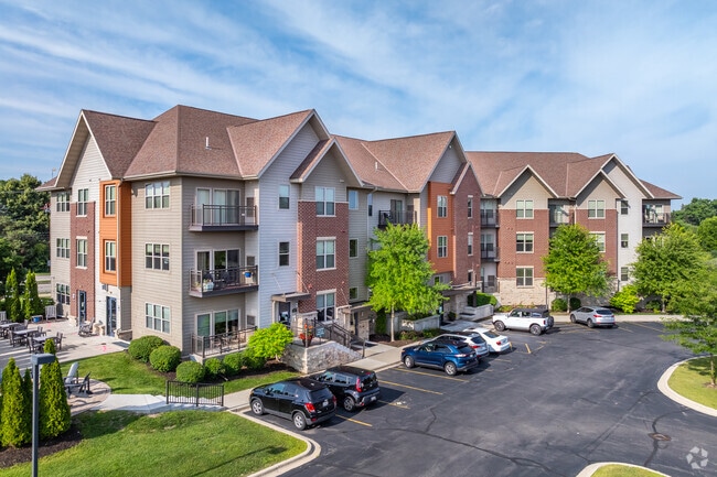
Property Record
W134n7249 Nelson Ln, Menomonee Falls, WI 53051
NEARBY LISTINGS FOR SALE OR LEASE
-
-
View all Menomonee Falls listings for sale on LoopNet.com
Property Detail
W134n7249 Nelson Ln
Milwaukee-Waukesha-West Allis, WI
Fussville
MNFV-0051-944-051
LOT 2 CERT SURV 10079 VOL 94/237 REC AS DOC# 3315502 PT LOTS 1-7 & 10-20 FUSSVILLE PT SW1/4 SEC 13 T8N R20E :: DOC# 4066483
Commercialnec
Waukesha
X
Wisconsin
55089C0240G
2
2024
2.44 AC
2024
Eastern Waukesha
200202
Milwaukee/Madison
112,222 SF
DEMOGRAPHICS near W134n7249 Nelson Ln
1 Mile
3 Mile
5 Mile
2024 Total Population
4,535
42,932
144,268
2029 Population
4,494
42,604
143,456
Pop Growth 2024-2029
(0.90%)
(0.76%)
(0.56%)
Average Age
42
41
39
2024 Total Households
1,864
17,983
57,081
HH Growth 2024-2029
(0.97%)
(0.76%)
(0.59%)
Median Household Inc
$102,994
$74,278
$65,910
Avg Household Size
2.40
2.30
2.50
2024 Avg HH Vehicles
2.00
2.00
2.00
Median Home Value
$371,304
$259,109
$242,496
Median Year Built
1991
1977
1969
Nearby Places
Map Layers
Map Styles
 Street
 Aerial
- Restaurants
- Banks
- Shops
- Fitness
- Groceries
PUBLIC TRANSPORTATION
AIRPORT
General Mitchell International
DRIVE
WALK
Distance
General Mitchell International
34 min
21.8 mi
Freight Ports
Port Milwaukee
DRIVE
WALK
Distance
Port Milwaukee
28 min
18.0 mi
Nearby Properties
Address
Land Use
TOTAL SIZE
Lot Size
Zoning
Address
Land Use
TOTAL SIZE
Lot Size
Zoning
369,652 SF
20 AC
Address
Land Use
TOTAL SIZE
Lot Size
Zoning
145,836 SF
11 AC
Address
Land Use
TOTAL SIZE
Lot Size
Zoning
121,472 SF
8.97 AC
Address
Land Use
TOTAL SIZE
Lot Size
Zoning
294,486 SF
12.78 AC
Address
Land Use
TOTAL SIZE
Lot Size
Zoning
864,365 SF
50.22 AC
Address
Land Use
TOTAL SIZE
Lot Size
Zoning
33.49 AC
TL
Address
Land Use
TOTAL SIZE
Lot Size
Zoning
222,355 SF
4.32 AC
Address
Land Use
TOTAL SIZE
Lot Size
Zoning
387,379 SF
20.25 AC
Address
Land Use
TOTAL SIZE
Lot Size
Zoning
530,458 SF
26.32 AC
Address
Land Use
TOTAL SIZE
Lot Size
Zoning
358,699 SF
24.97 AC
Address
Land Use
TOTAL SIZE
Lot Size
Zoning
197,426 SF
26.34 AC
PD
Address
Land Use
TOTAL SIZE
Lot Size
Zoning
Address
Land Use
TOTAL SIZE
Lot Size
Zoning
206,529 SF
7.88 AC
PD
Address
Land Use
TOTAL SIZE
Lot Size
Zoning
211,754 SF
30.52 AC
Address
Land Use
TOTAL SIZE
Lot Size
Zoning
13,717 SF
21.84 AC
IL1
Address
Land Use
TOTAL SIZE
Lot Size
Zoning
36,042 SF
4.51 AC
Address
Land Use
TOTAL SIZE
Lot Size
Zoning
292,944 SF
17.32 AC
Address
Land Use
TOTAL SIZE
Lot Size
Zoning
245,266 SF
18.11 AC
PD
Address
Land Use
TOTAL SIZE
Lot Size
Zoning
94,698 SF
10.67 AC
Address
Land Use
TOTAL SIZE
Lot Size
Zoning
91,708 SF
6.66 AC
Address
Land Use
TOTAL SIZE
Lot Size
Zoning
209,138 SF
14.70 AC
Address
Land Use
TOTAL SIZE
Lot Size
Zoning
204,175 SF
2.48 AC
Address
Land Use
TOTAL SIZE
Lot Size
Zoning
147,240 SF
2.53 AC
Address
Land Use
TOTAL SIZE
Lot Size
Zoning
147,240 SF
3.06 AC
Address
Land Use
TOTAL SIZE
Lot Size
Zoning
104,642 SF
7.06 AC
Address
Land Use
TOTAL SIZE
Lot Size
Zoning
302,895 SF
7.90 AC
Address
Land Use
TOTAL SIZE
Lot Size
Zoning
326,619 SF
30.69 AC
PD
Address
Land Use
TOTAL SIZE
Lot Size
Zoning
245,615 SF
15.88 AC
Address
Land Use
TOTAL SIZE
Lot Size
Zoning
160,000 SF
12.48 AC
Address
Land Use
TOTAL SIZE
Lot Size
Zoning
142,177 SF
2.60 AC
The World's #1 Commercial Real Estate Marketplace
Connect with us
© 2026 CoStar Group
The information above has been obtained from sources believed reliable. While we do not doubt its accuracy we have not verified it and make no guarantee, warranty or representation about it. It is your responsibility to independently confirm its accuracy and completeness. Any projections, opinions, assumptions, or estimates used are for example only and do not represent the current or future performance of the property. The value of this transaction to you depends on tax and other factors which should be evaluated by your tax, financial, and legal advisors. You and your advisors should conduct a careful, independent investigation of the property to determine to your satisfaction the suitability of the property for your needs.