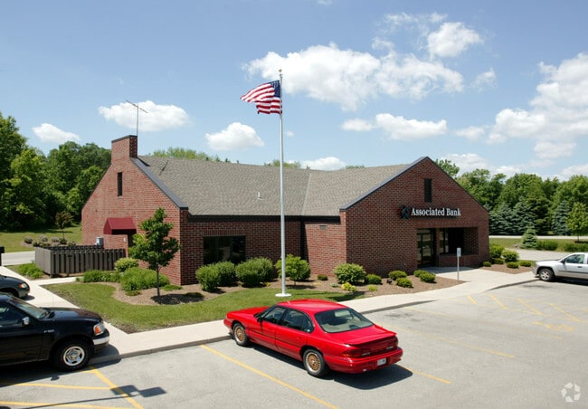
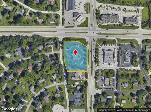
Property Record
W156n5575 Pilgrim Rd, Menomonee Falls, WI 53051
NEARBY LISTINGS FOR SALE OR LEASE
Property Detail
W156n5575 Pilgrim Rd
Milwaukee-Waukesha-West Allis, WI
Elm Lane
MNFV-0133-041
PT LOT 1 BLK 5 ELM LANE PT NE1/4 SEC 34 T8N R20E COM NE COR NE1/4 S00 1/200W 449.94 FT N89 1/259W 50.00 FT THE BGN N89 1/259W 30.00 FT S88 1/256W 204.50 FT NWLY ALG CURVE 28.52 FT N22 1/218W 9.39 FT NWLY ALG CURVE 153.51 FT N01 1/219W 161.72 FT S89 1
Commercialnec
Waukesha
X
Wisconsin
55133C0226H
1
2024
1.92 AC
2024
NE/Menomonee Falls
200500
Milwaukee/Madison
3,928 SF
DEMOGRAPHICS near W156n5575 Pilgrim Rd
1 Mile
3 Mile
5 Mile
2024 Total Population
3,941
35,862
138,801
2029 Population
4,003
36,727
139,359
Pop Growth 2024-2029
+ 1.57%
+ 2.41%
+ 0.40%
Average Age
43
42
40
2024 Total Households
1,505
14,161
55,621
HH Growth 2024-2029
+ 1.40%
+ 2.29%
+ 0.33%
Median Household Inc
$114,895
$100,070
$77,850
Avg Household Size
2.60
2.50
2.40
2024 Avg HH Vehicles
2.00
2.00
2.00
Median Home Value
$360,050
$349,212
$281,547
Median Year Built
1992
1978
1968
Nearby Places
Map Layers
Map Styles
 Street
 Aerial
- Restaurants
- Banks
- Shops
- Fitness
- Groceries
PUBLIC TRANSPORTATION
AIRPORT
General Mitchell International
DRIVE
WALK
Distance
General Mitchell International
35 min
21.5 mi
Freight Ports
Port Milwaukee
DRIVE
WALK
Distance
Port Milwaukee
29 min
17.7 mi
Nearby Properties
Address
Land Use
TOTAL SIZE
Lot Size
Zoning
Address
Land Use
TOTAL SIZE
Lot Size
Zoning
369,652 SF
20 AC
Address
Land Use
TOTAL SIZE
Lot Size
Zoning
26.49 AC
Address
Land Use
TOTAL SIZE
Lot Size
Zoning
121,472 SF
8.97 AC
Address
Land Use
TOTAL SIZE
Lot Size
Zoning
864,365 SF
50.22 AC
Address
Land Use
TOTAL SIZE
Lot Size
Zoning
222,355 SF
4.32 AC
Address
Land Use
TOTAL SIZE
Lot Size
Zoning
387,379 SF
20.25 AC
Address
Land Use
TOTAL SIZE
Lot Size
Zoning
21.87 AC
Address
Land Use
TOTAL SIZE
Lot Size
Zoning
145,844 SF
27.98 AC
Address
Land Use
TOTAL SIZE
Lot Size
Zoning
358,699 SF
24.97 AC
Address
Land Use
TOTAL SIZE
Lot Size
Zoning
192,963 SF
16.43 AC
Address
Land Use
TOTAL SIZE
Lot Size
Zoning
16.01 AC
Address
Land Use
TOTAL SIZE
Lot Size
Zoning
Address
Land Use
TOTAL SIZE
Lot Size
Zoning
21.66 AC
M2
Address
Land Use
TOTAL SIZE
Lot Size
Zoning
326,619 SF
30.69 AC
PD
Address
Land Use
TOTAL SIZE
Lot Size
Zoning
142,177 SF
2.60 AC
Address
Land Use
TOTAL SIZE
Lot Size
Zoning
12.48 AC
IL1
Address
Land Use
TOTAL SIZE
Lot Size
Zoning
378,511 SF
22.19 AC
Address
Land Use
TOTAL SIZE
Lot Size
Zoning
221,548 SF
11.80 AC
PD
Address
Land Use
TOTAL SIZE
Lot Size
Zoning
42.07 AC
IL1
Address
Land Use
TOTAL SIZE
Lot Size
Zoning
225,174 SF
6.68 AC
Address
Land Use
TOTAL SIZE
Lot Size
Zoning
181,083 SF
8.50 AC
Address
Land Use
TOTAL SIZE
Lot Size
Zoning
115,500 SF
13.08 AC
Address
Land Use
TOTAL SIZE
Lot Size
Zoning
515,706 SF
26.65 AC
Address
Land Use
TOTAL SIZE
Lot Size
Zoning
28.28 AC
M2
Address
Land Use
TOTAL SIZE
Lot Size
Zoning
157,152 SF
21.09 AC
Address
Land Use
TOTAL SIZE
Lot Size
Zoning
102,151 SF
10.34 AC
Address
Land Use
TOTAL SIZE
Lot Size
Zoning
Address
Land Use
TOTAL SIZE
Lot Size
Zoning
112,222 SF
2.44 AC
Address
Land Use
TOTAL SIZE
Lot Size
Zoning
8.65 AC
C2
Address
Land Use
TOTAL SIZE
Lot Size
Zoning
102,462 SF
10.94 AC
The World's #1 Commercial Real Estate Marketplace
Connect with us
© 2025 CoStar Group
The information above has been obtained from sources believed reliable. While we do not doubt its accuracy we have not verified it and make no guarantee, warranty or representation about it. It is your responsibility to independently confirm its accuracy and completeness. Any projections, opinions, assumptions, or estimates used are for example only and do not represent the current or future performance of the property. The value of this transaction to you depends on tax and other factors which should be evaluated by your tax, financial, and legal advisors. You and your advisors should conduct a careful, independent investigation of the property to determine to your satisfaction the suitability of the property for your needs.