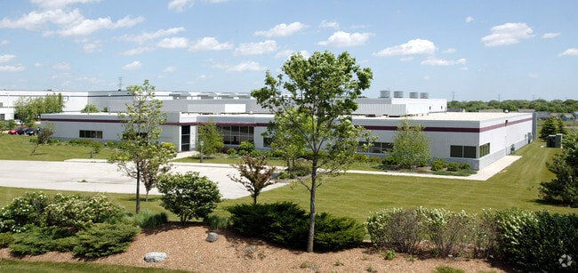
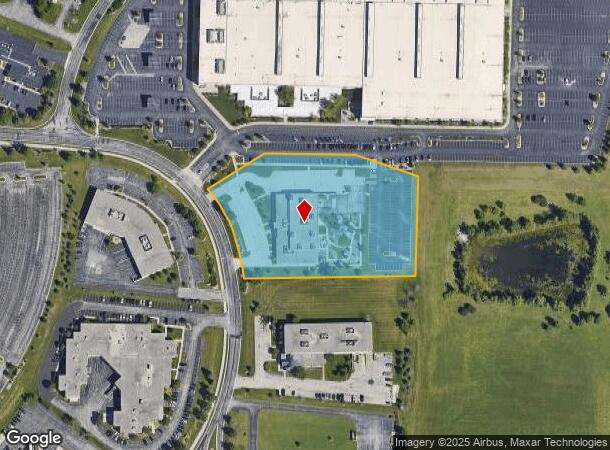
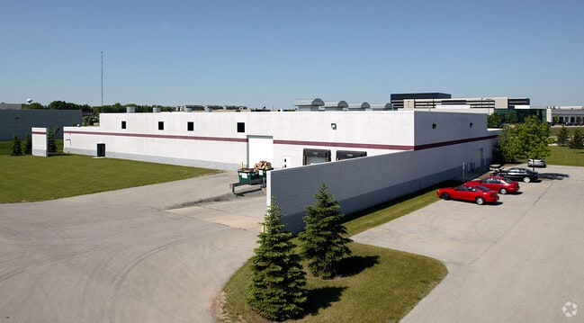
Property Record
W165n5800 Ridgewood Dr, Menomonee Falls, WI 53051
NEARBY LISTINGS FOR SALE OR LEASE
Property Detail
W165n5800 Ridgewood Dr
Milwaukee-Waukesha-West Allis, WI
Certified Surv Map 8400
MNFV-0107-997-006
LOT 20 CERT SURV 8400 VOL 73/316 4.162 AC PT SW1/4 & SE1/4 SEC 27 T8N R20E DOC# 3409636
Commercialnec
Waukesha
X
Wisconsin
55133C0226H
20
2024
4.16 AC
2024
NE/Menomonee Falls
200400
Milwaukee/Madison
23,690 SF
DEMOGRAPHICS near W165n5800 Ridgewood Dr
1 Mile
3 Mile
5 Mile
2024 Total Population
2,516
34,586
117,383
2029 Population
2,591
35,478
118,452
Pop Growth 2024-2029
+ 2.98%
+ 2.58%
+ 0.91%
Average Age
42
44
41
2024 Total Households
911
13,887
47,199
HH Growth 2024-2029
+ 2.96%
+ 2.54%
+ 0.83%
Median Household Inc
$143,269
$102,005
$83,989
Avg Household Size
2.70
2.40
2.40
2024 Avg HH Vehicles
2.00
2.00
2.00
Median Home Value
$368,608
$354,464
$300,883
Median Year Built
1993
1985
1971
Nearby Places
Map Layers
Map Styles
 Street
 Aerial
- Restaurants
- Banks
- Shops
- Fitness
- Groceries
PUBLIC TRANSPORTATION
AIRPORT
General Mitchell International
DRIVE
WALK
Distance
General Mitchell International
37 min
22.3 mi
Freight Ports
Port Milwaukee
DRIVE
WALK
Distance
Port Milwaukee
31 min
18.5 mi
SALE & LEASE HISTORY
LISTING DATE
SALE/LEASE

May 01, 2025
For Sale
Nearby Properties
Address
Land Use
TOTAL SIZE
Lot Size
Zoning
Address
Land Use
TOTAL SIZE
Lot Size
Zoning
26.49 AC
Address
Land Use
TOTAL SIZE
Lot Size
Zoning
145,836 SF
11 AC
Address
Land Use
TOTAL SIZE
Lot Size
Zoning
121,472 SF
8.97 AC
Address
Land Use
TOTAL SIZE
Lot Size
Zoning
294,486 SF
12.78 AC
Address
Land Use
TOTAL SIZE
Lot Size
Zoning
864,365 SF
50.22 AC
Address
Land Use
TOTAL SIZE
Lot Size
Zoning
222,355 SF
4.32 AC
Address
Land Use
TOTAL SIZE
Lot Size
Zoning
387,379 SF
20.25 AC
Address
Land Use
TOTAL SIZE
Lot Size
Zoning
21.87 AC
Address
Land Use
TOTAL SIZE
Lot Size
Zoning
145,844 SF
27.98 AC
Address
Land Use
TOTAL SIZE
Lot Size
Zoning
358,699 SF
24.97 AC
Address
Land Use
TOTAL SIZE
Lot Size
Zoning
192,963 SF
16.43 AC
Address
Land Use
TOTAL SIZE
Lot Size
Zoning
Address
Land Use
TOTAL SIZE
Lot Size
Zoning
302,895 SF
7.90 AC
Address
Land Use
TOTAL SIZE
Lot Size
Zoning
245,615 SF
15.88 AC
Address
Land Use
TOTAL SIZE
Lot Size
Zoning
142,177 SF
2.60 AC
Address
Land Use
TOTAL SIZE
Lot Size
Zoning
12.48 AC
IL1
Address
Land Use
TOTAL SIZE
Lot Size
Zoning
42.07 AC
IL1
Address
Land Use
TOTAL SIZE
Lot Size
Zoning
225,174 SF
6.68 AC
Address
Land Use
TOTAL SIZE
Lot Size
Zoning
181,083 SF
8.50 AC
Address
Land Use
TOTAL SIZE
Lot Size
Zoning
115,500 SF
13.08 AC
Address
Land Use
TOTAL SIZE
Lot Size
Zoning
515,706 SF
26.65 AC
Address
Land Use
TOTAL SIZE
Lot Size
Zoning
157,152 SF
21.09 AC
Address
Land Use
TOTAL SIZE
Lot Size
Zoning
112,222 SF
2.44 AC
Address
Land Use
TOTAL SIZE
Lot Size
Zoning
144,400 SF
10.16 AC
Address
Land Use
TOTAL SIZE
Lot Size
Zoning
3,385 SF
8.16 AC
Address
Land Use
TOTAL SIZE
Lot Size
Zoning
104,636 SF
11.97 AC
Address
Land Use
TOTAL SIZE
Lot Size
Zoning
13.04 AC
Address
Land Use
TOTAL SIZE
Lot Size
Zoning
Address
Land Use
TOTAL SIZE
Lot Size
Zoning
80,117 SF
6.51 AC
Address
Land Use
TOTAL SIZE
Lot Size
Zoning
5.91 AC
The World's #1 Commercial Real Estate Marketplace
Connect with us
© 2025 CoStar Group
The information above has been obtained from sources believed reliable. While we do not doubt its accuracy we have not verified it and make no guarantee, warranty or representation about it. It is your responsibility to independently confirm its accuracy and completeness. Any projections, opinions, assumptions, or estimates used are for example only and do not represent the current or future performance of the property. The value of this transaction to you depends on tax and other factors which should be evaluated by your tax, financial, and legal advisors. You and your advisors should conduct a careful, independent investigation of the property to determine to your satisfaction the suitability of the property for your needs.