Property Record
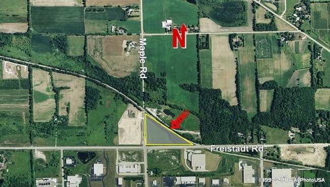
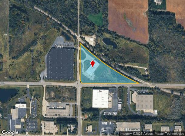
W188n12050 Maple Rd, Germantown, WI 53022
NEARBY LISTINGS FOR SALE OR LEASE
-
-
View all Germantown listings for sale on LoopNet.com
Property Detail
W188n12050 Maple Rd
GTNV-163995
PT OF SW SW LYING SWLY OF RR ROW DOC 1359132+1544682 (HWY V494 P351+V1627 P537)
Industrialgeneral
Washington
X
Wisconsin
55133C0100G
8.43 AC
2024
Washington East
2024
Milwaukee/Madison
470100
Milwaukee-Waukesha-West Allis, WI
DEMOGRAPHICS near W188n12050 Maple Rd
1 Mile
3 Mile
5 Mile
2024 Total Population
347
14,263
41,906
2029 Population
341
14,085
41,806
Pop Growth 2024-2029
(1.73%)
(1.25%)
(0.24%)
Average Age
41
43
43
2024 Total Households
136
5,971
17,119
HH Growth 2024-2029
(2.21%)
(1.44%)
(0.42%)
Median Household Inc
$102,404
$84,959
$95,294
Avg Household Size
2.50
2.40
2.40
2024 Avg HH Vehicles
2.00
2.00
2.00
Median Home Value
$341,666
$307,827
$298,932
Median Year Built
1990
1983
1978
Nearby Places
Map Layers
Map Styles
 Street
 Aerial
- Restaurants
- Banks
- Shops
- Fitness
- Groceries
PUBLIC TRANSPORTATION
AIRPORT
General Mitchell International
DRIVE
WALK
Distance
General Mitchell International
47 min
29.7 mi
Freight Ports
Port Milwaukee
DRIVE
WALK
Distance
Port Milwaukee
41 min
25.9 mi
Nearby Properties
Address
Land Use
TOTAL SIZE
Lot Size
Zoning
Address
Land Use
TOTAL SIZE
Lot Size
Zoning
706,000 SF
39.22 AC
Address
Land Use
TOTAL SIZE
Lot Size
Zoning
Address
Land Use
TOTAL SIZE
Lot Size
Zoning
240,468 SF
20.03 AC
Address
Land Use
TOTAL SIZE
Lot Size
Zoning
186,372 SF
22.16 AC
Address
Land Use
TOTAL SIZE
Lot Size
Zoning
Address
Land Use
TOTAL SIZE
Lot Size
Zoning
233,282 SF
17.13 AC
Address
Land Use
TOTAL SIZE
Lot Size
Zoning
23.77 AC
Address
Land Use
TOTAL SIZE
Lot Size
Zoning
Address
Land Use
TOTAL SIZE
Lot Size
Zoning
203,580 SF
13.52 AC
Address
Land Use
TOTAL SIZE
Lot Size
Zoning
204,373 SF
16.50 AC
Address
Land Use
TOTAL SIZE
Lot Size
Zoning
198,648 SF
16.57 AC
Address
Land Use
TOTAL SIZE
Lot Size
Zoning
24.02 AC
Address
Land Use
TOTAL SIZE
Lot Size
Zoning
153,383 SF
17.43 AC
Address
Land Use
TOTAL SIZE
Lot Size
Zoning
104.57 AC
Address
Land Use
TOTAL SIZE
Lot Size
Zoning
146,022 SF
8.51 AC
Address
Land Use
TOTAL SIZE
Lot Size
Zoning
Address
Land Use
TOTAL SIZE
Lot Size
Zoning
53,681 SF
38.43 AC
Address
Land Use
TOTAL SIZE
Lot Size
Zoning
130,000 SF
12.76 AC
Address
Land Use
TOTAL SIZE
Lot Size
Zoning
13,912 SF
10.30 AC
Address
Land Use
TOTAL SIZE
Lot Size
Zoning
99,710 SF
9.55 AC
Address
Land Use
TOTAL SIZE
Lot Size
Zoning
28,840 SF
12.02 AC
Address
Land Use
TOTAL SIZE
Lot Size
Zoning
Address
Land Use
TOTAL SIZE
Lot Size
Zoning
17.74 AC
Address
Land Use
TOTAL SIZE
Lot Size
Zoning
151,245 SF
17.54 AC
Address
Land Use
TOTAL SIZE
Lot Size
Zoning
28,800 SF
3.51 AC
Address
Land Use
TOTAL SIZE
Lot Size
Zoning
100,000 SF
13.07 AC
Address
Land Use
TOTAL SIZE
Lot Size
Zoning
12,000 SF
5.96 AC
Address
Land Use
TOTAL SIZE
Lot Size
Zoning
Address
Land Use
TOTAL SIZE
Lot Size
Zoning
55,490 SF
9.78 AC
Address
Land Use
TOTAL SIZE
Lot Size
Zoning
67,200 SF
5.90 AC
The World's #1 Commercial Real Estate Marketplace
Connect with us
© 2025 CoStar Group
The information above has been obtained from sources believed reliable. While we do not doubt its accuracy we have not verified it and make no guarantee, warranty or representation about it. It is your responsibility to independently confirm its accuracy and completeness. Any projections, opinions, assumptions, or estimates used are for example only and do not represent the current or future performance of the property. The value of this transaction to you depends on tax and other factors which should be evaluated by your tax, financial, and legal advisors. You and your advisors should conduct a careful, independent investigation of the property to determine to your satisfaction the suitability of the property for your needs.