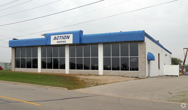
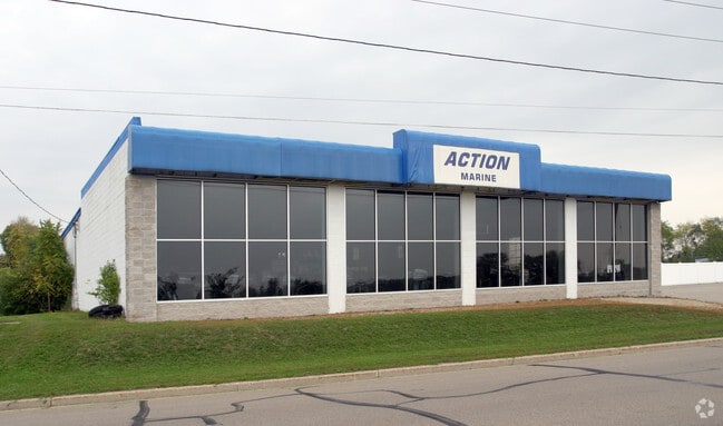
Property Record
W73 E Wisconsin Ave, Delafield, WI 53018


Property Detail
W73 E Wisconsin Ave
Milwaukee-Waukesha, WI
LOT 1 CSM #10857 VOL 105/208 REC AS DOC #3827198 PT NW1/4 SEC 6 T7N R18E
DELC-0742-986
WAUKESHA
Commercialnec
Wisconsin
B and X Area of moderate flood hazard, usually the area between the limits of the 100-year and 500-year floods.
1
2024
1.49 AC
2024
NE/Delafield
203702
Milwaukee/Madison
NEARBY LISTINGS FOR SALE OR LEASE
DEMOGRAPHICS near W73 E Wisconsin Ave
1 mile
3 mile
5 mile
2025 Total Population
2,155
18,482
56,929
2030 Population
2,213
19,264
58,807
Pop Growth 2025-2030
+ 2.69%
+ 4.23%
+ 3.30%
Average Age
45
45
43
2025 Total Households
906
7,441
23,065
HH Growth 2025-2030
+ 2.65%
+ 4.29%
+ 3.36%
Median Household Inc
$108,088
$122,443
$107,742
Avg Household Size
2.40
2.40
2.40
2025 Avg HH Vehicles
2.00
2.00
2.00
Median Home Value
$509,912
$555,664
$468,018
Median Year Built
1977
1985
1984
Nearby Places
Map Layers
Map Styles
 Street
 Aerial
Transit
 Traffic
 Biking
Places
Listings with unknown addresses are not visible on the map
- Restaurants
- Banks
- Shops
- Fitness
- Groceries
PUBLIC TRANSPORTATION
AIRPORT
General Mitchell International
Drive
Walk
Distance
General Mitchell International
50 min
35.2 mi
Freight Ports
Port Milwaukee
Drive
Walk
Distance
Port Milwaukee
43 min
31.7 mi
Nearby Properties
Address
Land Use
TOTAL SIZE
Lot Size
Zoning
Address
Land Use
TOTAL SIZE
Lot Size
Zoning
25.09 AC
Address
Land Use
TOTAL SIZE
Lot Size
Zoning
11.16 AC
Address
Land Use
TOTAL SIZE
Lot Size
Zoning
1.05 AC
Address
Land Use
TOTAL SIZE
Lot Size
Zoning
Address
Land Use
TOTAL SIZE
Lot Size
Zoning
Address
Land Use
TOTAL SIZE
Lot Size
Zoning
Address
Land Use
TOTAL SIZE
Lot Size
Zoning
13.48 AC
Address
Land Use
TOTAL SIZE
Lot Size
Zoning
1.71 AC
Address
Land Use
TOTAL SIZE
Lot Size
Zoning
Address
Land Use
TOTAL SIZE
Lot Size
Zoning
Address
Land Use
TOTAL SIZE
Lot Size
Zoning
15.06 AC
Address
Land Use
TOTAL SIZE
Lot Size
Zoning
6.87 AC
Address
Land Use
TOTAL SIZE
Lot Size
Zoning
3.79 AC
Address
Land Use
TOTAL SIZE
Lot Size
Zoning
3.59 AC
Address
Land Use
TOTAL SIZE
Lot Size
Zoning
Address
Land Use
TOTAL SIZE
Lot Size
Zoning
Address
Land Use
TOTAL SIZE
Lot Size
Zoning
Address
Land Use
TOTAL SIZE
Lot Size
Zoning
Address
Land Use
TOTAL SIZE
Lot Size
Zoning
Address
Land Use
TOTAL SIZE
Lot Size
Zoning
Address
Land Use
TOTAL SIZE
Lot Size
Zoning
158.84 AC
Address
Land Use
TOTAL SIZE
Lot Size
Zoning
Address
Land Use
TOTAL SIZE
Lot Size
Zoning
Address
Land Use
TOTAL SIZE
Lot Size
Zoning
Address
Land Use
TOTAL SIZE
Lot Size
Zoning
2.25 AC
Address
Land Use
TOTAL SIZE
Lot Size
Zoning
0.36 AC
Address
Land Use
TOTAL SIZE
Lot Size
Zoning
Address
Land Use
TOTAL SIZE
Lot Size
Zoning
2.83 AC
Address
Land Use
TOTAL SIZE
Lot Size
Zoning
1.26 AC
Address
Land Use
TOTAL SIZE
Lot Size
Zoning
14.74 AC
The World's #1 Commercial Real Estate Marketplace
Connect with us
© 2026 CoStar Group
The information above has been obtained from sources believed reliable. While we do not doubt its accuracy we have not verified it and make no guarantee, warranty or representation about it. It is your responsibility to independently confirm its accuracy and completeness. Any projections, opinions, assumptions, or estimates used are for example only and do not represent the current or future performance of the property. The value of this transaction to you depends on tax and other factors which should be evaluated by your tax, financial, and legal advisors. You and your advisors should conduct a careful, independent investigation of the property to determine to your satisfaction the suitability of the property for your needs.