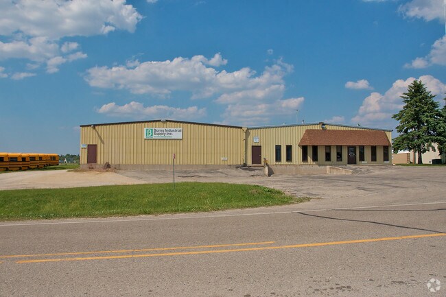
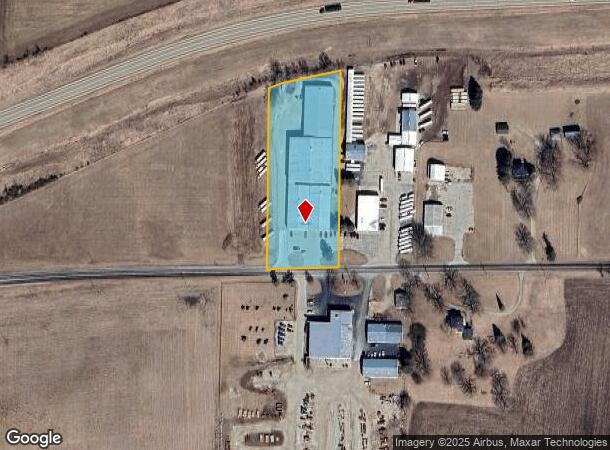
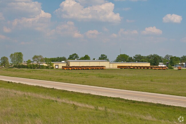
Property Record
W8622 Willis Ray Rd, Whitewater, WI 53190
NEARBY LISTINGS FOR SALE OR LEASE
Property Detail
W8622 Willis Ray Rd
DW900001B
PT SE 1/4 SEC 9 T4N R15E DESC AS: COM IN C/L WILLIS RAY RD 1110.8' E OF N&S 1/4 LN SEC 9, N02D11'E 570' TO S LN PROPOSED HWY
Industrialgeneral
Walworth
X
Wisconsin
55055C0453F
2.65 AC
2024
Walworth West
2024
Milwaukee/Madison
000400
Whitewater-Elkhorn, WI
DEMOGRAPHICS near W8622 Willis Ray Rd
1 Mile
3 Mile
5 Mile
2024 Total Population
1,306
16,156
17,778
2029 Population
1,326
16,385
17,997
Pop Growth 2024-2029
+ 1.53%
+ 1.42%
+ 1.23%
Average Age
39
32
34
2024 Total Households
553
5,433
6,088
HH Growth 2024-2029
+ 1.08%
+ 1.55%
+ 1.28%
Median Household Inc
$62,974
$40,510
$43,265
Avg Household Size
2.30
2.20
2.30
2024 Avg HH Vehicles
2.00
2.00
2.00
Median Home Value
$226,446
$220,932
$239,781
Median Year Built
1999
1981
1980
Nearby Places
Map Layers
Map Styles
 Street
 Aerial
- Restaurants
- Banks
- Shops
- Fitness
- Groceries
Nearby Properties
Address
Land Use
TOTAL SIZE
Lot Size
Zoning
Address
Land Use
TOTAL SIZE
Lot Size
Zoning
9.86 AC
Address
Land Use
TOTAL SIZE
Lot Size
Zoning
17.38 AC
Address
Land Use
TOTAL SIZE
Lot Size
Zoning
29.43 AC
Address
Land Use
TOTAL SIZE
Lot Size
Zoning
3.87 AC
Address
Land Use
TOTAL SIZE
Lot Size
Zoning
26.08 AC
Address
Land Use
TOTAL SIZE
Lot Size
Zoning
Address
Land Use
TOTAL SIZE
Lot Size
Zoning
4.28 AC
Address
Land Use
TOTAL SIZE
Lot Size
Zoning
9.30 AC
Address
Land Use
TOTAL SIZE
Lot Size
Zoning
Address
Land Use
TOTAL SIZE
Lot Size
Zoning
11.02 AC
Address
Land Use
TOTAL SIZE
Lot Size
Zoning
17.42 AC
Address
Land Use
TOTAL SIZE
Lot Size
Zoning
Address
Land Use
TOTAL SIZE
Lot Size
Zoning
3.34 AC
Address
Land Use
TOTAL SIZE
Lot Size
Zoning
Address
Land Use
TOTAL SIZE
Lot Size
Zoning
4.88 AC
Address
Land Use
TOTAL SIZE
Lot Size
Zoning
7.77 AC
Address
Land Use
TOTAL SIZE
Lot Size
Zoning
2.20 AC
Address
Land Use
TOTAL SIZE
Lot Size
Zoning
2.62 AC
Address
Land Use
TOTAL SIZE
Lot Size
Zoning
4.56 AC
Address
Land Use
TOTAL SIZE
Lot Size
Zoning
2.63 AC
Address
Land Use
TOTAL SIZE
Lot Size
Zoning
10.77 AC
Address
Land Use
TOTAL SIZE
Lot Size
Zoning
1.54 AC
Address
Land Use
TOTAL SIZE
Lot Size
Zoning
7.15 AC
Address
Land Use
TOTAL SIZE
Lot Size
Zoning
Address
Land Use
TOTAL SIZE
Lot Size
Zoning
1.62 AC
Address
Land Use
TOTAL SIZE
Lot Size
Zoning
0.19 AC
Address
Land Use
TOTAL SIZE
Lot Size
Zoning
Address
Land Use
TOTAL SIZE
Lot Size
Zoning
4.92 AC
Address
Land Use
TOTAL SIZE
Lot Size
Zoning
The World's #1 Commercial Real Estate Marketplace
Connect with us
© 2026 CoStar Group
The information above has been obtained from sources believed reliable. While we do not doubt its accuracy we have not verified it and make no guarantee, warranty or representation about it. It is your responsibility to independently confirm its accuracy and completeness. Any projections, opinions, assumptions, or estimates used are for example only and do not represent the current or future performance of the property. The value of this transaction to you depends on tax and other factors which should be evaluated by your tax, financial, and legal advisors. You and your advisors should conduct a careful, independent investigation of the property to determine to your satisfaction the suitability of the property for your needs.