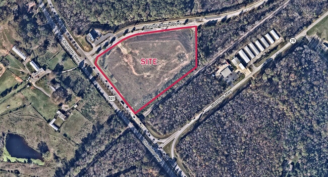
Property Record
Walnut Creek Pkwy, Lancaster, SC 29720

Property Detail
Walnut Creek Pkwy
Charlotte-Concord-Gastonia, NC-SC
LANCASTER
0020-00-002.02
South Carolina
Commercialnec
phase 2
B and X Area of moderate flood hazard, usually the area between the limits of the 100-year and 500-year floods.
10.10 AC
2025
Lancaster County
2025
Charlotte
011002
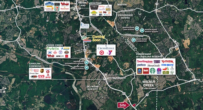
NEARBY LISTINGS FOR SALE OR LEASE
DEMOGRAPHICS near Walnut Creek Pkwy
1 mile
3 mile
5 mile
2025 Total Population
1,008
22,751
54,283
2030 Population
1,150
25,593
60,191
Pop Growth 2025-2030
+ 14.09%
+ 12.49%
+ 10.88%
Average Age
40
46
43
2025 Total Households
355
8,976
20,211
HH Growth 2025-2030
+ 14.37%
+ 12.69%
+ 11.25%
Median Household Inc
$90,166
$98,316
$100,957
Avg Household Size
2.80
2.50
2.70
2025 Avg HH Vehicles
2.00
2.00
2.00
Median Home Value
$451,282
$547,910
$499,171
Median Year Built
2011
2010
2009
Nearby Places
Map Layers
Map Styles
 Street
 Aerial
Layers
 Traffic
 Biking
Places
Listings with unknown addresses are not visible on the map
- Restaurants
- Banks
- Shops
- Fitness
- Groceries
PUBLIC TRANSPORTATION
AIRPORT
Charlotte/Douglas International
Drive
Walk
Distance
Charlotte/Douglas International
43 min
25.8 mi
Freight Ports
North Charleston Terminal
Drive
Walk
Distance
North Charleston Terminal
212 min
179.4 mi
Nearby Properties
Address
Land Use
TOTAL SIZE
Lot Size
Zoning
Address
Land Use
TOTAL SIZE
Lot Size
Zoning
1,200 SF
113.16 AC
R-40 UNION
Address
Land Use
TOTAL SIZE
Lot Size
Zoning
10,620 SF
2.68 AC
INS
Address
Land Use
TOTAL SIZE
Lot Size
Zoning
2,726 SF
12.25 AC
INS
Address
Land Use
TOTAL SIZE
Lot Size
Zoning
1,184 SF
38.39 AC
Address
Land Use
TOTAL SIZE
Lot Size
Zoning
146.15 AC
RN
Address
Land Use
TOTAL SIZE
Lot Size
Zoning
8,895 SF
13.02 AC
LDR
Address
Land Use
TOTAL SIZE
Lot Size
Zoning
10,846 SF
10.07 AC
CU R-4 PRD
Address
Land Use
TOTAL SIZE
Lot Size
Zoning
10,275 SF
2 AC
INS
Address
Land Use
TOTAL SIZE
Lot Size
Zoning
35,884 SF
8 AC
LI
Address
Land Use
TOTAL SIZE
Lot Size
Zoning
2,148 SF
21.60 AC
PDD
Address
Land Use
TOTAL SIZE
Lot Size
Zoning
4,424 SF
6.40 AC
INS
Address
Land Use
TOTAL SIZE
Lot Size
Zoning
2,878 SF
66.70 AC
PDD
Address
Land Use
TOTAL SIZE
Lot Size
Zoning
40.90 AC
CU R-4 PRD
Address
Land Use
TOTAL SIZE
Lot Size
Zoning
80,606 SF
5.08 AC
Address
Land Use
TOTAL SIZE
Lot Size
Zoning
8,270 SF
5 AC
INS
Address
Land Use
TOTAL SIZE
Lot Size
Zoning
6,366 SF
6.43 AC
INS
Address
Land Use
TOTAL SIZE
Lot Size
Zoning
1.14 AC
R-20 UNION
Address
Land Use
TOTAL SIZE
Lot Size
Zoning
2.11 AC
RA-40 UNIO
Address
Land Use
TOTAL SIZE
Lot Size
Zoning
15,000 SF
3.48 AC
LI UNION C
Address
Land Use
TOTAL SIZE
Lot Size
Zoning
86.29 AC
RA-40 UNIO
Address
Land Use
TOTAL SIZE
Lot Size
Zoning
0.25 AC
CU R-4 PRD
Address
Land Use
TOTAL SIZE
Lot Size
Zoning
0.26 AC
CU R-3 WAX
Address
Land Use
TOTAL SIZE
Lot Size
Zoning
0.23 AC
CU R-4 PRD
Address
Land Use
TOTAL SIZE
Lot Size
Zoning
0.24 AC
CU R-4 PRD
Address
Land Use
TOTAL SIZE
Lot Size
Zoning
41,574 SF
5.90 AC
PDD
Address
Land Use
TOTAL SIZE
Lot Size
Zoning
0.26 AC
CU R-4 PRD
Address
Land Use
TOTAL SIZE
Lot Size
Zoning
0.27 AC
CU R-3 WAX
Address
Land Use
TOTAL SIZE
Lot Size
Zoning
0.46 AC
R-20 UNION
Address
Land Use
TOTAL SIZE
Lot Size
Zoning
0.25 AC
CU R-3 WAX
Address
Land Use
TOTAL SIZE
Lot Size
Zoning
0.23 AC
CU R-4 PRD
The World's #1 Commercial Real Estate Marketplace
Connect with us
© 2026 CoStar Group
The information above has been obtained from sources believed reliable. While we do not doubt its accuracy we have not verified it and make no guarantee, warranty or representation about it. It is your responsibility to independently confirm its accuracy and completeness. Any projections, opinions, assumptions, or estimates used are for example only and do not represent the current or future performance of the property. The value of this transaction to you depends on tax and other factors which should be evaluated by your tax, financial, and legal advisors. You and your advisors should conduct a careful, independent investigation of the property to determine to your satisfaction the suitability of the property for your needs.